Maps of Mediterranean Sea

[Historisch-geographischer Atlas zu den allgemeinen Geschichtswerken von C. v. Rotteck, Pölitz u. Becker] : Italien eine Uebersicht seiner Völker und Staaten in der ältesten Zeit
von Julius Loewenberg Lithographie von B. Herder in Freiburg im Breisgau [Freiburg im Breisgau] : [Herder]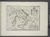
Italy, Sicily, &c.
from A new sett of maps both of antient and present geography : wherein not only the latitude and longitude of many places are corrected according to the latest observations, but also the most remarkable differences of antient and present geography may be quickly discern'd by a bare inspection or comparing of correspondent maps, which seems to be the most natural and easy method to lead young students (for whose use the work is principally intended) unto a competent knowledge of the geographical science : together with a geographical treatise particularly adapted to the use and design of these maps / by Edward Wells, M.A. and student of Christ-Church, Oxon.
M. Herberers ongelukkige voyagie gedaan in verscheyde gedeeltens van Asia en Africa
1 : 24000000 1 Karte : Kupferdruck ; 22 x 29 cm Aa, Pieter van der [Michel Herberer]
[LL.03949gk: 100/od/1943], uit: Kompas van Italië en Zuid-Oost Europa
1 : 3500000 Annotatie: Ook op de kaart: Tom Tas van Kompas; Vrijgegeven door W.B.N. [Wehrmachts Bereich in den Niederlanden] 30.10.'43; Grenzen van 1 sept. 1939; Op verso: incompleet gedeelte van wat waarschijnlijk poster is geweest, met tekst: Oranje Boot, half om half Den Haag : Kompas
Itinera expeditionum sacrarum
Europa, Mittelmeerraum, Reiseweg
Mer Mediterranee.
1 : 10000000 Garnier, F. A., 1803-1863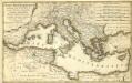
Mare Mediterranevm
1 : 5600000 Mollova mapová sbírka Homann, Johann Baptist Hauer, Daniel Adam Homann, Johann Baptista - dědici
Turquie in Europe.
from A new systeme of the mathematicks: containing I. Arithmetick, as well natural and decimal, as in species, or the principles of algebra. II. Practical geometry, together with the first six books of Euclid's Elements, as also the eleventh and twelfth, symbo
Carte generale de toute l'Europe, 5
1 Blatt : 56 x 46 cm J.M. Will
Totius Danubii nova & accuratiss. tabula, universam simul Turciam Europaeam, Hungariam magnam Germaniae partem, totam pene Italiam, atque una Moream cum Sicilia et Candia complectens
1 : 3000000 auctore Jacobo de la Feuille [Amsterdam], Jacobo de la Feuille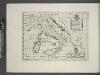
A new map of ancient Italy, together with the adjoyning islands of Sicily, Sardinia, and Corsica, shewing their principal divisions, cities, towns, rivers, mountains &c.
from A new sett of maps both of antient and present geography : wherein not only the latitude and longitude of many places are corrected according to the latest observations, but also the most remarkable differences of antient and present geography may be quickly discern'd by a bare inspection or comparing of correspondent maps, which seems to be the most natural and easy method to lead young students (for whose use the work is principally intended) unto a competent knowledge of the geographical science : together with a geographical treatise particularly adapted to the use and design of these maps / by Edward Wells, M.A. and student of Christ-Church, Oxon.
Karte des Mittelländischen Meeres
Středozemní moře-oblast Handtke, Friedrich C. Flemming
IMPERII TVRCICI EVROPAEI TERRA, in primis GRAECIA
1 : 4700000 Turecko Harenberg, Johann Christoph curantibus Homannianis Heredibus
Imperii Tvrcici Evropaei terra, in primis Graecia cum confiniis, ad intelligendos scriptores N.T. ceterosque graecos et latinos accom[m]odata
1 : 4530000 Turecko Harenberg, Johann Christoph curantibus Homannianis Heredibus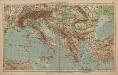
Italien und Balkanhalbinsel
1 : 9000000 Balkanhalbinsel, Italien
[Kaart], uit: Der Thüringerwald
1 : 150000 Annotatie: Verso: informatie [S.l. : Shell Reisedienst]
Italy, Turkey, Greece, Europe.
Goodrich, S.G.
Italien
1 : 5000000 1 Karte Top. Anstalt v. J. Wurster, Winterthur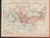
L'Empire Grec au Commencement du IX.e siècle
Byzantinisches Reich Kümmerly & Frey
Generalkarte der Mittelmeerländer
Nieuwe paskaart van de Middelanse Zee
Mediterranean Christoffel Middaghten Gerard van Keulen
Schema glavnějšjch peredviženīj ėskadry admirala Ušakova i někotorych eja otděl'nych sudov v vojnu s Francīej 1798-1800 gg.
Mittelmeer Seeschlacht Ušakov, Fedor
Imperii Tvrcici Evropaei Terra, in primis Graecia cum confiniis
1 : 4400000 Mollova mapová sbírka Harenberg, Johann Christoph Homann, Johann Baptista - dědici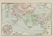
Die Kreuzzüge
Mittelmeerraum, Byzantinisches Reich, Kreuzzüge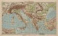
Italien und Balkanhalbinsel
1 : 6000000 Balkanhalbinsel, Italien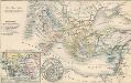
Die Zeit der Kreuzzüge
Südeuropa, Mittelmeerraum, Kreuzzüge
Karte zur Geschichte der Kreuzzüge
1 : 6500000 Evropa jihovýchodní Cremersche Buchhandlung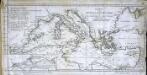
Charte vom mittellændischen Meer
1 Karte : Kupferdruck ; 23 x 49 cm Abel; Cotta im Verlag der J. G. Cotta'schen Buchhandlung
Imperii Turcici Europaei Terra, in primis Graecia cum confiniis
1 : 4400000 Mollova mapová sbírka Harenberg, Johann Christoph Homann, Johann Baptista - dědici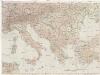
![[Historisch-geographischer Atlas zu den allgemeinen Geschichtswerken von C. v. Rotteck, Pölitz u. Becker] : Italien eine Uebersicht seiner Völker und Staaten in der ältesten Zeit](https://images-2.georeferencer.com/images/iiif/712211866332/full/,300/0/native.jpg)

