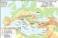
Maps of Mediterranean Sea

[Historisch-geographischer Atlas zu den allgemeinen Geschichtswerken von C. v. Rotteck, Pölitz u. Becker] : Die Küsten des Mittelländischen Meeres zur Uebersicht der ältesten Kolonisationen
von Julius Loewenberg [Freiburg im Breisgau] : [Herder]
Kriegszusammenhänge II (1672-1699)
1 : 25000000 Europa Englisch-Niederländischer Seekrieg <1672-1674>, Türkenkriege
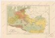
Österreich-Ungarn und Bosnien-Hercegovina
Eberle, Joseph

Napoleons Heereszüge : von seinem Auftreten als Ober-General der Armee von Italien 1796 bis zu seiner Thron-Entsagung nach der Schlacht bey Waterloo 1815
Entworfen von F.W. Benicken gravirt v. C. Halle Weimar : im Verlage des Landes Industrie-Comptoirs
Paasche's Frontenkarte, Nr. 11 Europäische Kriegsschauplätze
Südosteuropa im Frühmittelalter mit Jireček-Linie
Südosteuropa Sprachgeografie Zwick, J.
Europa Temporibus Expeditionum Sacrarum
Europa Kreuzzüge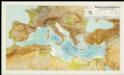
Mapa de la Conca Mediterrània: principals infrastructures de transport : regions europees riberenques de la Mediterrània
1 : 3500000 1 Mapa. Institut Cartogràfic de Catalunya ICC
Europa und das oström. Reich zur Zeit der Kreuzzüge
Europa, Byzantinisches Reich, Kreuzzüge
Europa Aetate Napoleontis I
Europa Napoleon I., Frankreich, Kaiser
Overland Route To India.
1 : 24000000 Tallis, J. & F.

Eisenbahn- Post- und Dampfschiffahrts-Karte von Europa
1 : 8000000 Evropa Denk, L. Lith. Anst. v. L. Mohn's Witwe

Europa 1993
Europa Kunz, Andreas ; Moeschl, Joachim Robert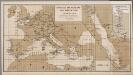
[Europa], uit: Routekaart van Nederland naar Ned. Indië en terug
1 : 8000000 Annotatie: Samengest. op uitnoodiging der Stoomvaart Maatschappij Nederland Groustra, J. Amsterdam : Seyffardt
Europa zu Anfang des 6ten Jahrhunderts
Europa Völkerwanderung
Europa 1964
Europa Kunz, Andreas ; Moeschl, Joachim Robert
Roman Empire, Greece.
1 : 17000000 Mitchell, Samuel Augustus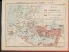
L'Empire Grec au temps de Justinien (VI.e siècle)
Byzantinisches Reich Justinian I.
Gemaelde des Roemischen Reichs in seiner grösten Ausdehnung
Historisch-genealogisch-geographischer Atlas von Le Sage Las Cases, Emmanuel Auguste Dieudonné Marius Joseph de Johann Velten, Kunsthändler
Das Römische Reich
Malá Asie
L'Europe au Temps des Croisades.
Andriveau-Goujon, J.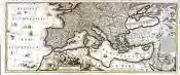
Mare Mediterraneum
1 Karte auf 2 Blättern : Kupferdruck ; 42 x 103 cm by Iohannes Cóvens en Cornelis Mortier
Říše římská v době největší své rozsáhlosti
Evropa za stěhování národů

Europa 6.8.1806
Europa Kunz, Andreas ; Moeschl, Joachim Robert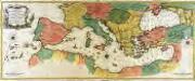
Carte geographique representant la mer Mediterranée ou la seconde partie du théatre de la guerre entre les Russes et les Turcs
1 Karte auf 3 Blättern : Kupferdruck ; 53 x 130 cm Lotter Tobias Konrad Lotter
![[Historisch-geographischer Atlas zu den allgemeinen Geschichtswerken von C. v. Rotteck, Pölitz u. Becker] : Die Küsten des Mittelländischen Meeres zur Uebersicht der ältesten Kolonisationen](https://images-2.georeferencer.com/images/iiif/999287925238/full/,300/0/native.jpg)

