Maps of Canadian Shield

[Neuer Atlas der ganzen Erde nach den neuesten Bestimmungen ... : V.] Nord-Amerika und West-Indien
Entworfen und gezeichnet von Dr. F.W. Streit H. Leutemann sc. Leipzig : J.C. Hinrichs'sche Buchhandlung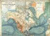
Physikalische Wandkarte der Erde in Merkartor's Projection
Asia, W. Hemisphere.
Goodrich, S.G.
Map of North America
1 : 5000000 Aleutské ostrovy (Aljaška) U. S. Geological Survey
Severní Amerika
1 : 46500000 Severní Amerika Merklas, Václav
Nordamerika.
1 : 20000000 Andree, Richard
Asia.
1 : 25000000 Johnson, A.J.
L'Asie.
1 : 19000000 Brue, Adrien Hubert, 1786-1832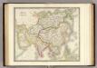
Asia.
1 : 27500000 Teesdale, Henry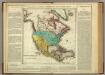
North America.
1 : 25000000 Lea, I.
Asien
1 : 43038000 Asie Schlieben Gleditsch
Asia.
1 : 45000000 Morse, Jedidiah; Morse, Sidney E. (Sidney Edwards), 1794-1871
Map of North America Including All The Recent Geographical Discoveries. 1826.
1 : 17424000 Finley, Anthony
North America.
1 : 14982000 Johnston, W. & A.K.
L'Amerique Septentrionale.
1 : 19000000 Lapie, M. (Pierre), 1779-1850
Asia.
1 : 35000000 Colton, G.W.
North America.
1 : 23000000 Mitchell, Samuel Augustus
Asia.
1 : 47000000 Morse, Jedidiah; Morse, Sidney E. (Sidney Edwards), 1794-1871
Asia
1 : 30175000 Colton, G. Woolworth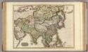
Asia.
1 : 17600000 Pinkerton, John, 1758-1826
North America.
1 : 20600000 Schlitz Brewing Company
Asia.
1 : 30000000 Colton, G.W.
North America.
1 : 22500000 Tanner, Henry S.
North America.
1 : 23300000 Tanner, Henry S.
North America.
1 : 23300000 Tanner, Henry S.
North America.
1 : 17000000 Johnson, A.J.
North America.
1 : 17000000 Johnson, A.J.
North America - political.
1 : 17000000 John Bartholomew & Co.
North America.
1 : 15000000 Rand McNally and Company
![[Neuer Atlas der ganzen Erde nach den neuesten Bestimmungen ... : V.] Nord-Amerika und West-Indien](https://images-2.georeferencer.com/images/iiif/131943500273/full/,300/0/native.jpg)

