Maps of Europe

[Geschichtlich-geographischer Atlas von Europa :] XII. Karte von Europa zur Zeit der grössten Ausdehnung des französischen Kaiserreichs im Jahre 1812
entworfen und gezeichnet durch Ferd. Aug. v. Witzleben bei K. Kolbe gest. v. A. Heimburger [Berlin etc.] : [Mittler]
[Geschichtlich-geographischer Atlas von Europa :] VII. Karte von Europa beim Ende der Regierung Friedrichs des Rothbarts im Jahre 1190
entworfen und gezeichnet durch Ferd. Aug. v. Witzleben Gestochen bei K. Kolbe von August Heimburger [Berlin etc.] : [Mittler]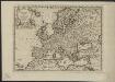
L'Europe, suivant les nouvelles observations de Messrs. de l'Academie Royale des Sciences, etc.
1 : 5100000 augmentées de nouveau Leyde : chez Pierre van der Aa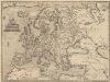
Europae [Karte], in: Theatrum orbis terrarum, S. 52.
1 Karte aus Atlas Ortelius, Abraham Vrients, Jan Baptista
Europa 1804
Europa Kunz, Andreas ; Moeschl, Joachim Robert
[Botanisch-Geographisch-Statistische Karte von Europa]
Zweiter Band, enthaltend in vier Abtheilungen die Vertheilung der Organismen: 5. Pflanzen-Geographie, 6. Thier-Geographie, 7. Anthropographie, 8. Ethnographie Humboldt, Alexander von Verlag von Justus Perthes
Europa 1789
Europa Kunz, Andreas ; Moeschl, Joachim Robert
Europa 1867
Europa Kunz, Andreas ; Röss, Wolf ; Moeschl, Joachim Robert
Europa Post Bellum Triginta Annorum. (1650-1700)
Europa Westfälischer Friede
Europa. Staaten
1 : 24000000 Europa Politische Geografie
Europa 1812
Europa Kunz, Andreas ; Moeschl, Joachim Robert
EVROPA
recens descripta | à | Guilielmo Blaeuw. [Amsterdam : Joan Blaeu]
Europa 2008
Europa Kunz, Andreas ; Moeschl, Joachim Robert
Europa 1993
Europa Kunz, Andreas ; Moeschl, Joachim Robert
Europa 1861
Europa Kunz, Andreas ; Röss, Wolf ; Moeschl, Joachim Robert
Europa 1795
Europa Kunz, Andreas ; Moeschl, Joachim Robert
Carte Geologique De L'Europe.
1 : 3800000 Dumont, Andre
Europa 1820
Europa Kunz, Andreas ; Röss, Wolf ; Moeschl, Joachim Robert
Europa zur Uebersicht der Flussgebiete und Höhenzüge
Hand-Atlas über alle Theile der Erde nach dem neuesten Zustande und über das Weltgebäude Stieler, Adolf bei Justus Perthes
Europa Exactissime Descripta [Karte], in: Gerardi Mercatoris et I. Hondii Newer Atlas, oder, Grosses Weltbuch, Bd. 1, S. 30.
1 Karte aus Atlas Mercator, Gerhard und Hondius, Jodocus Jansson, Jan
Europa 1914
Europa Kunz, Andreas ; Moeschl, Joachim Robert
Europa 1812 - Das napoleonische Staatensystem
Europa Kunz, Andreas ; Moeschl, Joachim Robert
Europe : laid down from the observations of the Royal Academy of Sciences & compared with the maps of Sanson, Nolin, Du Fer, De l'Isle, Moll & other modern geographers ... / [John Bowles] ; engrav'd by Emanuel Bowen
1 : 4500000 Annotatie: Met tabel van Europese lengtematen; Met informatie over de verschillende Europese staten Bowles, John; Bowen, Emanuel London : printed for John Bowles
[Geschichtlich-geographischer Atlas von Europa :] VI. Karte von Europa beim Ende der Regierung Otto des Grossen im Jahre 973
entworfen und gezeichnet durch Ferd. Aug. v. Witzleben Gestochen bei K. Kolbe von August Heimburger [Berlin etc.] : [Mittler]
Europa 1881
Europa Kunz, Andreas ; Röss, Wolf ; Moeschl, Joachim Robert
Europa um 1740
1 : 15000000 Europa
Europa 1908
Europa Kunz, Andreas ; Röss, Wolf ; Moeschl, Joachim Robert
Europa 1885
Europa Kunz, Andreas ; Röss, Wolf ; Moeschl, Joachim Robert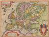
Europam, Sive Celticam Veterem [Karte], in: Theatrum orbis terrarum, S. 362.
1 Karte aus Atlas Ortelius, Abraham
![[Geschichtlich-geographischer Atlas von Europa :] XII. Karte von Europa zur Zeit der grössten Ausdehnung des französischen Kaiserreichs im Jahre 1812](https://images-2.georeferencer.com/images/iiif/509495358618/full/,300/0/native.jpg)

