Maps of Sahara
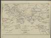
[Hierographie, oder topographisch-synchronistische Darstellung der Geschichte der christlichen Kirche] : VII. Von Gregor d. Gr. bis auf Carl d. G. J. 604-800
1 : 8400000 W.A. Möller Lith. bey Arnz & Co. in Düsseldorf Elberfeld : Büschler
[Hierographie, oder topographisch-synchronistische Darstellung der Geschichte der christlichen Kirche] : IV. Von Constantin bis auf Gregor d. G. J. 325-604
1 : 8400000 W.A. Möller Lith. bey Arnz & Co. in Düsseldorf Elberfeld : Büschler
[Hierographie, oder topographisch-synchronistische Darstellung der Geschichte der christlichen Kirche] : VI. Von Constantin bis auf Gregor d. G. J. 325-604
1 : 8400000 W.A. Möller Lith. bey Arnz & Co. in Düsseldorf Elberfeld : Büschler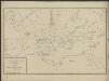
[Hierographie, oder topographisch-synchronistische Darstellung der Geschichte der christlichen Kirche] : II. Von Paulus bis Origines
1 : 8400000 W.A. Möller Lith. bey Arnz & Co. in Düsseldorf Elberfeld : Büschler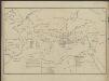
[Hierographie, oder topographisch-synchronistische Darstellung der Geschichte der christlichen Kirche] : I. Zeiten der Apostel
1 : 8400000 W.A. Möller Lith. bey Arnz & Co. in Düsseldorf Elberfeld : Büschler
[Hierographie, oder topographisch-synchronistische Darstellung der Geschichte der christlichen Kirche] : V. Von Constantin bis auf Gregor d. G. J. 325-604
1 : 8400000 W.A. Möller Lith. bey Arnz & Co. in Düsseldorf Elberfeld : Büschler
[Hierographie, oder topographisch-synchronistische Darstellung der Geschichte der christlichen Kirche] : III. Origines - Nicaea
1 : 8400000 W.A. Möller Lith. bey Arnz & Co. in Düsseldorf Elberfeld : Büschler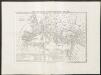
Carta generale dell'impero romano sotto Costantino
1 : 11000000 Marzolla, Benedetto [Verlag nicht ermittelbar]
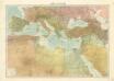
Verbreitung der Religionen im Anfange von Justinians Regierung
1 : 30000000 Europa Justinian I., Byzantinisches Reich, Kaiser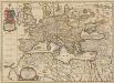
Europa Antiqua cum finitimis Africae & utriusque Asiae regionibus. [Karte], in: Novus atlas absolutissimus, Bd. 10, S. 33.
1 Karte aus Atlas Janssonius Offizin
Imperium Romanum inde a bello Actiaco usque ad Diocletiani tempus.
1 : 15000000 Menke, Th.

Europa antiqua cum finitimis Africæ & utriusque Asiæ regionibus / Nicolaus Blancardus ... delineabat
1 : 10000000 Annotatie: Origineel is Blad 2 in atlas factice Blanckaert, Nicolaas [Amsterdam : Joannes Janssonius]
Imperium Romanum Antiquum
Römisches Reich
Das Römische Reich in der Kaiserzeit
starověký Řím Gindely, Antonín F. Tempsky
[Geschichtlich-geographischer Atlas von Europa :] III. Karte des Roemischen Reichs in seiner grössten Ausdehnung
entworfen und gezeichnet durch Ferd. Aug. v. Witzleben Gestochen bei K. Kolbe von Leop. Müller [Berlin etc.] : [Mittler]
Empire Romain.
Andriveau-Goujon, J.
Carte des peuples de l’Europe centrale lors de l’apparation des Huns, au 4e siècle de notre ère
Mitteleuropa ethnische Gruppe, Völkerwanderungszeit
Gemälde der grossen Wanderungen der Barbaren
Historisch-genealogisch-geographischer Atlas von Le Sage Las Cases, Emmanuel Auguste Dieudonné Marius Joseph de Johann Velten, Kunsthändler
Terre aux trois fils de Noe.
1 : 23500000 Houze, Antoine Philippe
Země při moři Středozemském v době největší rozsáhlosti říše perské

[Geschichtlich-geographischer Atlas von Europa :] IV. Karte Europa’s Während der Blüthe des Ost-Gothischen Reichs unter Theodorich im Anfange des 6ten Jahrhundert’s; nebst den Zügen Alarich’s und Attila’s
entworfen und gezeichnet durch F.A. v. Witzleben Gest. bei K. Kolbe von H. Hertzberg [Berlin etc.] : [Mittler]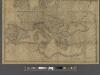
A new map of Europe exhibiting its natural and political divisions drawn from the most recent materials
From Whole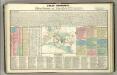
Tableau historique de Rome ancienne.
1 : 23700000 Duval, Henri
Imperium Romanum tempore Constantini Magni
Středomoří

Imperium Romanum.
1 : 15000000 Kiepert, Heinrich, 1818-1899
Ancient Roman empire
J. Dower Henry Teesdale & C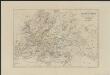
[Historisch-geographischer Atlas zu den allgemeinen Geschichtswerken von C. v. Rotteck, Pölitz u. Becker] : Übersichtskarte für die Geschichte vom Ende der Kreuzzüge bis zur Reformation
von Julius Loewenberg Lithographie von B. Herder in Freiburg im Breisgau 1836 [Freiburg im Breisgau] : [Herder]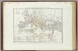
![[Hierographie, oder topographisch-synchronistische Darstellung der Geschichte der christlichen Kirche] : VII. Von Gregor d. Gr. bis auf Carl d. G. J. 604-800](https://images-2.georeferencer.com/images/iiif/706095618085/full/,300/0/native.jpg)

