Maps of India

Schul-Atlas für die alte Erdbeschreibung : zur allgemeinen Schul-encyclopädie gehörig
J. H. Campe Zusammensetzung und Zeichnung von [...] Dufour, unter Leitung von Heusinger ; gestochen von Frentzel. Braunschweig : Schulbuchhandlung
India and Indochina. Pergamon World Atlas.
1 : 10000000 Polish Army Topography Service
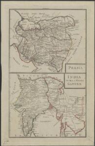
1 Partie de la nouvelle grande carte des Indes Orientales, contenant les terres du Mogol, Surate, Malabar, Cormandel, Bengale, Aracan, Pegu, Siam, Camboje, Tonquin & une partie de la Chine
1 : 8000000 dressée avec soin, sur plusieurs cartes munuscrites, par un habile connoisseur, & publiée A Amsterdam : par R. & J. Ottens
Empire du Mogol.
1 : 14000000 Clouet, J. B. L. (Jean-Baptiste Louis), b. 1730
India & Farther India - political.
1 : 10000000 John Bartholomew & Co.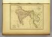
l'Indie.
1 : 20200000 Malte-Brun, Conrad, 1775-1826
Composite: India.
1 : 4000000 John Bartholomew & Co.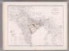
India and Adjacent Countries. Coal Resources of the World.
1 : 8553600 McInnes, William; Leach, W.W.; Dowling, D.B.
Composite: Carte Generale des Indies.
1 : 9500000 Vivien de St Martin, L.
Asie Meridionale.
1 : 14000000 Garnier, F. A., 1803-1863
An accurate map of Hindostan or India, from the best authorities.
from Carey's general atlas, improved and enlarged : being a collection of maps of the world and quarters, their principal empires, kingdoms, &c.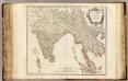
Indes Orientales.
1 : 8500000 Robert de Vaugondy, Gilles, 1688-1766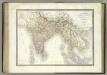
L'Inde.
1 : 10100000 Lapie, M. (Pierre), 1779-1850
[Ost Indien, Mit besonderer Berücksichtigung der englischen Besitzungen]
Geographischer Atlas über alle Theile der Erde Ziegler, Jakob Melchior Verlag von Joh. Wurster um Comp.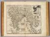
Mogul Empire, India.
1 : 11000000 Bowen, Emanuel
Hindostan Or British India.
1 : 14630000 Johnson, A.J.
Ost Indien.
1 : 9500000 Ziegler, J. M.
Vorder-Indien oder das Indo-Britische Reich
Hand-Atlas über alle Theile der Erde nach dem neuesten Zustande und über das Weltgebäude Stieler, Adolf bei Justus Perthes

Ost Indien
Hypsometrischer Atlas Ziegler, Jakob Melchior Topogr. Anstalt v. J. Wurster u. Comp.
Carte des possessions anglaises de l'Inde, comprenant les établissements anglais dans l'Indoustan, l'Indo-Chine et la Chine / par A.H. Dufour ; gravée par Regnier et Dourdet
1 : 7800000 Dufour, Auguste Henri; Regnier, ...; Dourdet, ... Paris : Paulin et le Chevalier
India
1 : 8000000 Afghánistán James, J. O. N. Surveyor general's office
Map of Hindoostan, Farther India, China, and Tibet
1 : 18000000 Mitchell, Samuel Augustus Jr.
Language Map of India and ist Border Lands
Hindoostan and Farther India.
1 : 10200000 Johnson, A.J.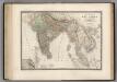
Inde.
1 : 8500000 Levasseur, E.
Hindostan Or British India.
1 : 14889600 Johnson, A.J.
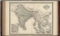
Hindoostan, Farther India, China, Tibet.
1 : 17500000 Williams, W. (Wellington)
Map Of Hindoostan, Farther India, China, and Tibet.
1 : 17600000 Mitchell, Samuel Augustus