Maps of Israel

Maps of Israel

$title$

Afbeelding van 't land van Israël, naar deszelfs natuurlyke gesteltheid : waar in alle de zeën, rivieren en beeken, gelyk ook de bergen en dalen, de vlaktens, de woestynen, enz. dezes lands, die in de H.S. genoemt zyn, worden aangewezen
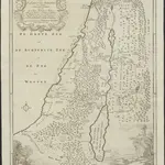
1 : 750000 door W.A. Bachiene J. van Jagen sculp. ; J.C. Philips fecit. te Gorinchem : by Nicolaas Goetzee
$title$

't Land Kanaan benevens Gilead verdeelt onder de XII stammen Israëls waar in de gelegendheid en uitgestrektheid van ieder erfdeel word aangewezen

1 : 700000 door W.A. Bachiene J. van Jagen mapp. sculpsit, et figur. apposit. sculpturam curavit ; J.C. Philips fecit. Uitgegeven te Gorinchem : by Nicolaas Goetzee
$title$

Aardrijkskundige, plaatsbeschrijvende en geschiedkundige kaart van Palestina of het Heilige land

1 : 281000 oorspronkelijk geteekend door J.T. Assheton [...] bijzonderlijk wat de teekening betreft naauwkeurig herz. en verb. door E. Maaskamp ; onder toezigt en medew. van [...] J. Clarisse Te Amsterdam : bij E. Maaskamp, thans het eigendom van J. C. van Kesteren, boekhandelaar en boekdrukker te Amsterdam
$title$

Schul-Atlas für die alte Erdbeschreibung : zur allgemeinen Schul-encyclopädie gehörig

J. H. Campe Zusammensetzung und Zeichnung von [...] Dufour, unter Leitung von Heusinger ; gestochen von Frentzel. Braunschweig : Schulbuchhandlung
$title$

Palestine.

1 : 684288 Stanford, Edward
$title$

Palestine ou Terre Sainte.

1 : 610000 Lapie, M. (Pierre), 1779-1850
$title$

Judaea sive Terra Sancta quae Israelitarum suas duodecim tribus distincta, secretis ab invicem regnis Juda, et Israel expressis in super sex ejusdem terrae provincijs

1 : 650000 ex conatibus geographicis Gulielmi Sanson [...] Amst[erdam] : ex officina R. & J. Ottens
$title$

Judaea seu Terra Sancta quae Hebraeorum sive Israelitarum in suas duodecim tribus divisa, secretis ab invicem regnis Juda, et Israel expressis insuper sex ultimi temporis ejusdem terrae provincijs

1 : 740000 ex conatibus geographicis Gulielmi Sanson [...] A Amsterdam : chez Pierre Schenk
$title$

$title$

Karte von Palaestina

1 : 1030000 Jeruzalém Klöden, Karl Friedrich von Mare, Carl bei August Rücker
$title$

Homannův atlas světa

1 : 570000
$title$

Palestine sous la domination romaine.

1 : 800000 Brue, Adrien Hubert, 1786-1832
$title$

Bez titulu: Historický Atlas

$title$

Palestine.

1 : 1650000 Monin, C.V.
$title$

Kaart van het Heilige Land ten tijde van Josua en de Regteren

1 : 1100000 S.I. Mulder del. steend. v. C. W. Mieling [Leyden] : D. du Mortier & Fil. excud.
$title$

Palaestina za času Krista Pána

1 : 1030000 Izrael Fáborský, Jan B. Dědictví sv. Cyrilla a Methodia
$title$

Palaestina za času Krista Pána

1 : 1030000 Izrael Fáborský, Jan B. Dědictví sv. Cyrilla a Methodia
$title$

Palestine.

1 : 1120000 Finley, Anthony
$title$

Palestina za doby soudců a králů

$title$

Turkey in Asia (Biblical Regions) The Holy Land And Its Borders.

1 : 696960 Fullarton, A. & Co.
$title$

Palestine

1 : 1000000 Colton, G.W.
$title$

Palestine.

1 : 1000000 Colton, G.W.
$title$

Palestina čili Kanaan

Palestina Fried, Franz Luther, Th. nákladem Spolku Komenského
$title$

$title$

Palestine.

1 : 1130000 Tanner, Henry S.
$title$

Palestine ancienne & moderne d'après les sources les plus authentiques

1 : 600000 Andriveau-Goujon, E. (Eugène), 1832-1897 E. Andriveau-Goujon
$title$

Iudaea, seu Terra Sancta quae hebraeorum sive Israelitarum in suas duodecim tribus divisa, secretis ab invicem regnis Iuda, et Israel expressis insuper sex ultimi temporis ejusdem terrae provinciis

1 : 600000 Izrael Sanson, Guillaume Schenk, Pieter Pierre Schenk
$title$

Iudaea, seu Terra Sancta quae Hebraeorum sive Israelitarum in suas duodecim tribus divisa, secretis ab invicem regnis Iuda, et Israel expressis insuper sex ultimi temporis ejusdem terrae provinciis

1 : 600000 Izrael Sanson, Guillaume Schenk, Pieter Pierre Schenk
$title$

Douze Tribus d'Israel.

1 : 1030000 Bonne, Rigobert, 1727-1794
$title$

Terre de Canaan á present la Palestine

1 : 1100000 Kanaán
© MapTiler © OpenStreetMap contributors
How does it work?
These instructions will show you how to find historical maps online.
Getting started
Type the place name in the search box to find the exact location. You can further adjust the search by zooming in and out.
Zoom
Zoom in and out with the buttons or use your mouse or touchpad natively.
Exact Area tool
Click here and draw a rectangle over the map to precisely define the search area.
Set filters
Narrow your search with advanced settings, such as Years (from/to), Fulltext, Publisher, etc.
Results
See the results of your search on the right side. You can scroll down to find more maps of this location.
?

Download OldMapsOnline Mobile