Maps of Miesbach

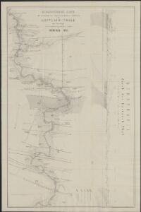
Geognostische Karte der miocänen und oligocänen Molasse-Schichten im Leitzach-Thale bei Miesbach : zur Versammlung der deutschen Geologen in München 1875
1 : 10000 grav. von C. Bernhard [S.l.] : Druckerei des k. Oberbergamtes
189. Tegernsee, uit: Topographische Uebersichtskarte des Deutschen Reiches / herausgegeben v. d. Kartogr. Abt. d. Königl. Preuß. Landesaufnahme
1 : 200000 titelvariant: Topogr. Übersichtskarte des Deutschen Reiches; Annotatie: Titel boven bladen ook: Topogr. Übersichtskarte des Deutschen Reiches; Annotatie geografische gegevens: Op elk blad twee maatstokken: 10 Kilometer = 5,5 cm; 1 geogr. Meile = 3,6 cm; Legenda onder op elk blad Königlich Preußische Landesaufnahme. Kartographische Abtheilung [S.l : Königlich Preußische Landesaufnahme, Kartographische Abtheilung]
Tyrolis sub Felici Regimine Mariae Theresiae Rom. Imper. Avg. Chorographice Delineata ...
1 : 104000 Mollova mapová sbírka Mansfeld, Johann Ernst Mansfeld, Johann Ernest
Sistit Partem Dicast.ii Monach: et Burchh: ex utraqué Parte Oeni Merid. versus, cum Dÿnastia Burgrain, Hohen-Waldeck; Archi-Episc: Salisb: et finibus c: Tir
1 : 150000 Mollova mapová sbírka Buna, Wilhelm C. Broenner, Heinrich Ludwig
Pars VIII. sistit partem dicast.ii Monach: et Burchh: ex utraqué parte Oeni merid. versus, cum dÿnastia Burgrain, Hohen=Waldeck; archi=episc: Salisb: et finibus c: Tir
1 Karte : 54 x 52 cm Heinrich Ludwig Broenner
[Tirol]
Tyrolsko (Rakousko) Woerl Herder, B. B. Herder
München 143, uit: Special-Karte von Mittel-Europa / nach amtlichen Quellen bearbeitet von W. Liebenow
1 : 300000 titelvariant: W. Liebenow's Mittel-Europa; Annotatie: Titel boven de bladen: W. Liebenow's Mittel-Europa Johannes Wilhelm Liebenow 1822-1897 Frankfurt a. M. : Ludwig Ravenstein
Tyrolis sub Felici Regimine Mariae Theresiae Rom. Imper. Avg. Chorographice Delineata ...
1 : 104000 Mollova mapová sbírka Mansfeld, Johann Ernst Mansfeld, Johann Ernest
Carte topographique d'Allemagne contenant une partie de la Baviere, de l'eveché de Salzburg, de Tirol
1 Karte : Kupferdruck ; 46 x 63 cm Jaeger se vend chez l'auteur
Gebirgs-Karte
Alpy rakouské (pohoří) in Commission der literarisch-artistischen Anstalt
Mappa Electoratus et Ducatus Bavariae Superioris et Inferioris, Ducatus Neoburgesis cum Episcopatibus Frisingensi Ratisbonensi Passaviensi et Praepositura Bergtolsgadensi].
1 : 260000 Mollova mapová sbírka Apian, Philipp
Sacri Romani imperii circuli et electoratus Bavariae tabula, 5
6 Blätter : s.n.
Accurata Delineatio Episcopat. Frisingensis
1 : 266600 Mollova mapová sbírka Seutter, Matthäus Seutter, Matthäus
Tyrolis sub Felici Regimine Mariae Theresiae Rom. Imper. Avg. Chorographice Delineata ...
1 : 104000 Mollova mapová sbírka Mansfeld, Johann Ernst Mansfeld, Johann Ernest
Tyrolis sub Felici Regimine Mariae Theresiae Rom. Imper. Avg. Chorographice Delineata ...
1 : 104000 Mollova mapová sbírka Mansfeld, Johann Ernst Mansfeld, Johann Ernest
Tyrolis sub Felici Regimine Mariae Theresiae Rom. Imper. Avg. Chorographice Delineata ...
1 : 104000 Mollova mapová sbírka Mansfeld, Johann Ernst Mansfeld, Johann Ernest
Tyrolis sub Felici Regimine Mariae Theresiae Rom. Imper. Avg. Chorographice Delineata ...
1 : 104000 Mollova mapová sbírka Mansfeld, Johann Ernst Mansfeld, Johann Ernest
Militair Karte von Süd-Deutschland in 20 Sectionen
1 : 400000 15. Section Coulon, Alois von A. von Coulon

Salisburgensis jurisdictionis locorumque vicinorum vera descriptio
1 Karte : Kupferdruck ; 18 x 26 cm Quad; Nagel; Bussemacher; Secznagel Johannes Bussemacher
Sacri imperii Romani circuli et electoratus Bavariæ, 3
1 Karte : mehrfarbig ; R. et J. Ottens
Spezial-Karte von Salzburg, Salzkammergut und einen Theil von Tyrol
1 : 320000 Salcbursko (Rakousko) Orlitsek, Fr. Vesco, Ciprian Ciprian Vesco's sel. Witw.
Spezial-karte von Salzburg, Salzkammergut und einen Theil von Tyrol
1 : 350000 Horní Rakousko (Rakousko) Orlitsek, Fr. Tritschlen, J. Ciprian Vesco's fel. Witw.
[Fol. III]
1 Karte : 43 x 55 cm Königliche Akademie der Wissenschaften
Das Herzogthum Ober und Nieder Baiern, 3
1 Karte : 43 x 55 cm Lotter
Karte der Salzburger-Alpen und des Salzkammerguts
1 : 250000 Salcburské Alpy (Rakousko : pohoří) Ravenstein, Ludwig L. Ravenstein
Accurata delineatio episcopat[us] Frisingensis
1 Karte : Kupferdruck ; 55 x 47 cm Lotter Tobias Conrad Lotter
Accurata delineatio episcopat[us] Frisingensis
1 Karte : Kupferdruck ; 54 x 48 cm Seutter Matthäus Seutter
Erz-Herzogthum Oesterreich, Land ob der Enns
1 : 360000 Salcburk-oblast (Rakousko) Renner A. Platt