Maps of Polynesia
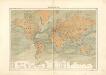
Nouveau planisphère indiquant les grandes divisions physiques et politiques de la terre, la géographie statistique et industrielle des differents états, les colonies européenes et l'époque des principales découvertes
1 : 47000000 dressé par A. Vuillemin gravé par Langevin Paris [etc.] : Turgis
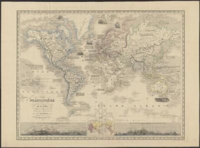
Planisphère illustré présentant la description géographique des parties connues de la terre : indiquant l'époque des grandes découvertes et le nom des navigateurs, les colonies des diverses nations ainsi que le parcours des bateaux à vapeur, l'époque des départs, la durée du trajet &c. / dressé par Vuillemin ; gravé par Langevin
1 : 34000000 Annotatie: Met diverse kostuumfiguren, overzicht van de hoogste bergen en overzicht van de langste rivieren Vuillemin, A.; Langevin, ... Paris : Fatout
Florenreiche der Erde auf der Grundlage von W. Köppens Wärmegürteln nach der Dauer der heissen, gemässigten und kalten Zeit
1 : 120000000 Drude, Oscar Engelhorn
Windkarte der Erde
Erster Band, enthaltend in vier Abtheilungen die Erscheinungen der anorganischen Natur: 1. Meteorologie und Klimatographie. 2. Hydrologie und Hydrographie. 3. Geologie. 4. Tellurischer Magnetismus Humboldt, Alexander von Verlag von Justus Perthes
Orbis Typus Universalis Iuxta Hydrographorum Traditionem [Karte], in: Claudii Ptolemei viri Alexandrini mathematice discipline philosophi doctissimi geographie opus [...], S. 230.
1 Karte aus Atlas Waldseemüller, Martin [und Ptolemaeus, Claudius] Übelin, Georg
Übersichts-Karte für die wichtigsten Culturpflanzen der Erde, mit Angabe ihres Vaterlandes und ihrer geographischen Verbreitung
Atlas der Pflanzengeographie über alle Theile der Erde Rudolphi, Ludwig Verlag der Nicolaischen Buchhandlung
Pflanzengeographische Eintheilung der Erdoberfläche
1 : 50000000 Schouw, Joakim Frederik [Reimer?]
Übersicht der Mittleren Barometerstände am Meere und der Oscillation des Luftdrucks
Erster Band, enthaltend in vier Abtheilungen die Erscheinungen der anorganischen Natur: 1. Meteorologie und Klimatographie. 2. Hydrologie und Hydrographie. 3. Geologie. 4. Tellurischer Magnetismus Humboldt, Alexander von Verlag von Justus Perthes
Hyetographische Karte der Erde
Erster Band, enthaltend in vier Abtheilungen die Erscheinungen der anorganischen Natur: 1. Meteorologie und Klimatographie. 2. Hydrologie und Hydrographie. 3. Geologie. 4. Tellurischer Magnetismus Humboldt, Alexander von Verlag von Justus Perthes
Atlas für Industrie- und Handelsgeographie: Für commercielle und technische Lehranstalten, für Kaufleute und Industrielle
Atlas für Industrie- und Handelsgeographie: Für commercielle und technische Lehranstalten, für Kaufleute und Industrielle

The World
A new general atlas of modern geography, consisting of a complete collection of maps of the four quarters of the globe Wyld, James James Wyld
World, Mercator's projection.
1 : 82000000 Hall, S. (Sidney)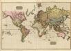
The World on Mercator's projection.
1 : 40000000 Pinkerton, John, 1758-1826
Orbis Terrae Compendiosa Descriptio [Karte], in: Gerardi Mercatoris Atlas, sive, Cosmographicae meditationes de fabrica mundi et fabricati figura, S. 58.
1 Karte aus Atlas Mercator, Gerhard Montanus, Petrus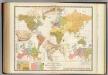
Religious belief.
1 : 66000000 Johnston, Alexander Keith, 1804-1871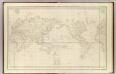
Mappemonde.
1 : 50000000 La Perouse, Jean-Francois de Galaup, comte de, 1741-1788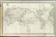
Mappemonde.
1 : 50000000 La Perouse, Jean-Francois de Galaup, comte de, 1741-1788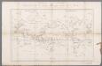
Carte générale du voyage pittoresque autour du monde : sur laquelle l'Océanie a été reduite d'après la carte de Mr. d'Urville & sous sa direction / gravé par Ambroise Tardieu
1 : 100000000 Dumont d'Urville, Jules Sébastian César; Tardieu, Ambroise [S.l. : s.n.]
Typus Orbis A Ptol. Descriptus [Karte], in: Claud. Ptolemaeus. Geographia lat. cum mappis [...], S. 251.
1 Karte aus Atlas Münster, Sebastian [und Ptolemaeus, Claudius]
I. Charte für die allgemeine Geschichte von den frühesten bekannten Zeiten bis zur Zerstörung von Troja
Entworfen von F.W. Benicken Weimar : im Verlage des L. Industrie-Comptoirs
Pharmacognostische Karte zur Pharmacopoea Germanica
1 : 85000000 Schelenz, H. E. [Buchh. des Waisenhauses]
VI. Charte für die allgemeine Geschichte von Carl dem Grossen bis auf Papst Gregor VII. : d.i. von 768 bis 1073 nach Christus
Entworfen von F.W. Benicken gez. von C.F. Weiland ; in Stein gravirt v. A. Falger Weimar : im Verlage des L. Industrie-Comptoirs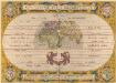
Aevi Veteris, Typus Geographicus. [Karte], in: Theatrum orbis terrarum, S. 359.
1 Karte aus Atlas Ortelius, Abraham
Karte für die in den Jahren 1827-1831 Beobachteten Werthe der Declination
Erster Band, enthaltend in vier Abtheilungen die Erscheinungen der anorganischen Natur: 1. Meteorologie und Klimatographie. 2. Hydrologie und Hydrographie. 3. Geologie. 4. Tellurischer Magnetismus Humboldt, Alexander von Verlag von Justus Perthes
[Erdkarte in Mercators Projektion, Übersicht der Meeresströmungen und der Weltverkehrlinien]
Volksschul-Atlas über alle Teile der Erde Lange, Henry Druck und Verlag von Georg Westermann
Planisphère
1 : 57000000 Izarny-Gargas; France. Service géographique de l'armée [Paris] :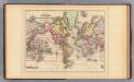
World Mercator proj.
1 : 97000000 Mitchell, Samuel Augustus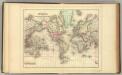
World Mercator proj.
1 : 97000000 Mitchell, Samuel Augustus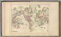
World Mercator proj.
1 : 97000000 Mitchell, Samuel Augustus Jr.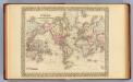
World Mercator proj.
1 : 100000000 Mitchell, Samuel Augustus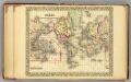
World.
1 : 95000000 Mitchell, Samuel Augustus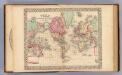
World Mercator proj.
1 : 100000000 Mitchell, Samuel Augustus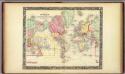
Map Of The World On The Mercator Projection.
1 : 100000000 Mitchell, Samuel Augustus
The world, on Mercator's projection
1 : 74000000 Burr, David H., 1803-1875 Published by J. Haven, 86 State St.
Allgemeine Ornitho- und Erpetologische Erdkarte.
1 : 130000000 Berghaus, Heinrich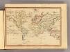
The World, Mercator's projection.
1 : 255000000 Fenner, Rest.
Routes par lesquelles les richesses metalliques.
1 : 160000000 Humboldt, Alexander von, 1769-1859