Maps of United States Minor Outlying Islands

Spitsbergen
1 : 1400000 R. van Wijk Jacz. del. [Dordrecht : J. de Vos & Comp.]
Het noordelijkste van de Zuijd Zee van California tot Japan vertoonde seer naaukeurig het Compagnies Land
Pacific Ocean Gerard van Keulen
Nord-America und West-Indien
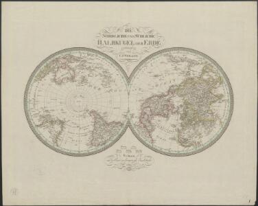
Schul-Atlas über alle Theile der Erde nach dem neuesten Zustande, und über das Weltgebäude Stieler, Adolf Justus Perthes
[Nord-Amerika]
Hypsometrischer Atlas Ziegler, Jakob Melchior Topogr. Anstalt v. J. Wurster u. Comp.
Nord-America
Neuer Handatlas über alle Theile der Erde Kiepert, Heinrich Verlag von Dietrich Reimer

TARTARIA | sive | MAGNI CHAMI | IMPERIVM.
[Amsterdam : Joan Blaeu]
North America
A new general atlas of modern geography, consisting of a complete collection of maps of the four quarters of the globe Wyld, James James Wyld
Nord-Amerika
[Allgemeiner Atlas über alle Theile der Erde in 29 Blättern] Ziegler, Jakob Melchior Top. Anstalt v. J. Wurster u. Comp.
Charte des Stillen Weltmeers im Nördlichen Aequator und der Küsten die es auf beiden Seiten einschraenken : nach den neuesten, von den Spaniern, Russen und Engellaendern bis 1780 gemachten Entdeckungen
1 : 37000000 [erl. von:] T. A. Mann Augsbourg : Tobie Conrad Lotter
Nord Amerika
Geographischer Atlas über alle Theile der Erde Ziegler, Jakob Melchior Verlag von Dietrich Reimer
Nord-America
Hand-Atlas über alle Theile der Erde nach dem neuesten Zustande und über das Weltgebäude Stieler, Adolf bei Justus Perthes
Nord-Amerika
Geographischer Atlas über alle Theile der Erde Ziegler, Jakob Melchior Verlag von Joh. Wurster um Comp.
Carte marine entre Californie et une partie de l'Asie la plus orientale
1 Karte : Kupferdruck ; 41 x 48 cm Königliche Akademie der Wissenschaften
One world, one war; a map showing the line-up and the strategic stakes in this the first global war
"North polar azimuthal equidistant projection." "A Fortune map." "Supplement to Fortune, March, 1942." Includes text and maps of "The Atlantic bridge" and "The Pacific vastness." Harrison, Richard Edes and Time, inc [New York] : Time
Oceanie 1.
1 : 15500000 Brue, Adrien Hubert, 1786-1832
Poli Arctici, Et Circumiacentium Terrarum Descriptio Novissima. [Karte], in: Gerardi Mercatoris et I. Hondii Newer Atlas, oder, Grosses Weltbuch, Bd. 1, S. 42.
1 Karte aus Atlas Mercator, Gerhard und Hondius, Jodocus Jansson, Jan
Map of Europe, showing its gt. political divisions.
from New general atlas.
The kingdome of China
1 : 5000000 Speed, John, 1552?-1629 Are to be sold in Popshead Alley by G. Humble
[Ergänzungen und Berichtungen]
Geographischer Atlas über alle Theile der Erde Ziegler, Jakob Melchior Verlag von Dietrich Reimer
Der noerdliche Theil des grossen Welt Meeres
1 Karte : Kupferdruck ; 48 x 65 cm Reichard im Verlage d. Industrie Comptoirs
Europe.
from A new sett of maps both of antient and present geography : wherein not only the latitude and longitude of many places are corrected according to the latest observations, but also the most remarkable differences of antient and present geography may be quickly discern'd by a bare inspection or comparing of correspondent maps, which seems to be the most natural and easy method to lead young students (for whose use the work is principally intended) unto a competent knowledge of the geographical science : together with a geographical treatise particularly adapted to the use and design of these maps / by Edward Wells, M.A. and student of Christ-Church, Oxon.
Der noerdliche Theil des grossen Welt Meeres / von C. G. Reichard im Jahre 1804 ; Nach des Herrn von
1 : 11100000 1 Karte : Kupferdruck ; 49 x 67 cm Reichard, Christian Gottlieb Theophil im Verlage des Geograph. Instituts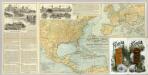
N. America, W. Europe passenger lines.
1 : 14130000 Associated Railway Land Dept of Florida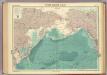
North Pacific Ocean.
1 : 25000000 John Bartholomew & Co.
Meteorological chart of the North Pacific Ocean
1 : 11000000 Tichý oceán (severní oblast) Secretary of Agriculture
Meteorological chart of the North Pacific Ocean
1 : 11000000 Tichý oceán (severní oblast) Secretary of Agriculture
Meteorological chart of the North Pacific Ocean
1 : 11000000 Tichý oceán (severní oblast) Secretary of Agriculture
Meteorological chart of the North Pacific Ocean
1 : 11000000 Tichý oceán (severní oblast) Secretary of Agriculture