Maps of Seven Seas (Open Ocean)
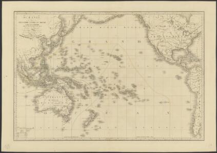
Océanie ou cinquième partie du monde
1 : 29450000 carte encyprotype réduite de celle sur 4 feuilles du même auteur par A. Brué [...] Paris : chez Ch. Picquet
[Polynesien und der Grosse Ocean (westliches Blatt)]
Adolf Stieler's Handatlas über alle Theile der Erde und über das Weltgebäude Stieler, Adolf Justus Perthes
[Polynesien und der Grosse Ocean, Westliches Blatt]
Hand-Atlas über alle Theile der Erde und über das Weltgebäude Stieler, Adolf Justus Perthes
Les câbles anglais
1 : 80000000 Léon de Montarlot; Le monde illustré Paris : Le Monde illustré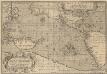
Maris Pacifici, (quod vulgò Mar del Zur) cum regionibus circumiacentibus [...] [Karte], in: Theatrum orbis terrarum, S. 64.
1 Karte aus Atlas Ortelius, Abraham Vrients, Jan Baptista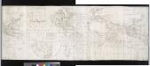
A correct chart of the terraqueous globe, according to Mercator's, or more properly Wright's projection, on which are describ'd lines, shewing the variation of the magnetic needle according to observations made about the year 1744.; Accuratissima totius terrarum orbis tabula nautica / celeberrimo viro Edmd. Halley, LLD., anno 1700 contructa; indice variationes magneticas denota[m?] ad observationes circiter annu 1744 habitas renovata Gulielmo Mountaine et Jacobo Dodson.
from Charts and maps Halley, Edmund; Mountaine, Guielmo; Dodson, Jacobo,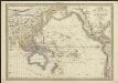
Carte de l'Océanie comprenant l'Australie, la Polynésie et du Grand Archipel d'Asie
1 : 37000000 dressée par Hérisson, géographe gravé par J. B. Tardieu ; Pelicier scrip. Paris : chez Jean, Rue St. Jean-de-Beauvais, No. 10
[Karte vom Grossen Ocean, Zur Übersicht der Strömungen, Temperatur und Handels-Strassen]
Erster Band, enthaltend in vier Abtheilungen die Erscheinungen der anorganischen Natur: 1. Meteorologie und Klimatographie. 2. Hydrologie und Hydrographie. 3. Geologie. 4. Tellurischer Magnetismus Humboldt, Alexander von Verlag von Justus Perthes
Physical Chart of the Pacific Ocean
The physical atlas Johnston, Alexander Keith William Blackwood & Sons
[Zoological Geography, Geographical Division and Distribution of Reptilia (Reptiles)]
The physical atlas Johnston, Alexander Keith William Blackwood & Sons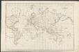
Allgemeine Weltcharte
1 : 45400000 nach Mercators Projection entworfen von A.I. Krusenstern, Capitain der Russischen Marine J. Walker sculpt. ; verb. bis zum Jahre 1818. London : [s.n.]
Karte von dem Vulkan Gürtel und den Central Gruppen des Grossen Oceans
Erster Band, enthaltend in vier Abtheilungen die Erscheinungen der anorganischen Natur: 1. Meteorologie und Klimatographie. 2. Hydrologie und Hydrographie. 3. Geologie. 4. Tellurischer Magnetismus Humboldt, Alexander von Verlag von Justus Perthes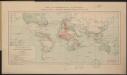
Carte des communications télégraphiques
1 : 70000000 Mager, Henri 1859-19..; L'Expansion française coloniale Paris : L'Expansion coloniale française
[Zoological Geography, Geographical Division & Distribution of Rodentia (Gnawing Animals)]
The physical atlas Johnston, Alexander Keith William Blackwood & Sons
Westlicher Planiglob der Erde
1 : 17000000 Weimar : Verlag des Geographischen Instituts
[Polynesien und der Grosse Ocean, westliches Blatt]
Handatlas über alle Theile der Erde und über das Weltgebäude Stieler, Adolf Justus Perthes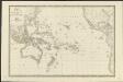
Carte de l'Océanie ou cinquième partie du monde
1 : 26450000 par A. H. Brué, Geographe de S.A.R. Monsieur A Paris [etc.] : [chez J. Goujon, Rue du Bac, No. 6, près le Pont Royal, [etc.]
Mar del Zur Hispanis Mare Pacificum. [Karte], in: De Nieuwe Groote Vermeerderde Zee-Atlas ofte Water-Werelt, S. 71.
1 Karte aus Atlas Doncker, Hendrick
[Zoological Geography, Geographical Division and Distribution of the Birds of Europe]
The physical atlas Johnston, Alexander Keith William Blackwood & Sons
Wereldkaart volgens Mercator's projectie
Bruxelles : Institut National de Géographie
Mar Del Zur Hispanis Mare Pacificum. [Karte], in: Novus atlas absolutissimus, Bd. 9, S. 136.
1 Karte aus Atlas Janssonius Offizin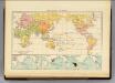
Religions.
1 : 114000000 Andree, Richard; Times (London, England)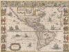
Americae nova Tabula. [Karte], in: Theatrum orbis terrarum, sive, Atlas novus, Bd. 2, S. 307.
1 Karte aus Atlas Blaeu, Joan Blaeu, Willem Janszoon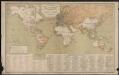
Carte générale des lignes télégraphiques internationales
1 : 40000000 Jaccottey, Paul Paris : Ch. Delagrave
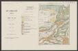
Atlas über die Entwicklung von Industrie und Handel der Schweiz in dem Zeitraume vom Jahr 1770 bis zum Jahr 1870
1 : 500000 Absatzgebiete des Schweizerischen Ausfuhrhandels 1770 Wartmann, Hermann Wurster Randegger & Co.
Australien
Allgemeiner Atlas [Walch, Johannes] im Verlag bei Johannes Walch
[Historisch-geographischer Atlas zu den allgemeinen Geschichtswerken von C. v. Rotteck, Pölitz u. Becker] : Erdansichten nach den im Mittelalter herrschenden Systemen
von Julius Loewenberg [Freiburg im Breisgau] : [Herder]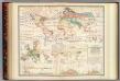
Distribution: plants.
1 : 67000000 Johnston, Alexander Keith, 1804-1871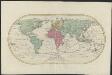
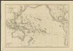
Mappemonde ou Carte générale de l' univers sur une projection nouvelle d'une sphére ovale pour mieux entendre les distances entre l'Europe et Amerique : avec le tour du monde du lieut. Cook et tous les découvertes nouvelles
1 : 45000000 dessinée et gravée par Mathieu Albert Lotter A Augsbourg : [s.n.]