Maps of Israel

Maps of Israel

$title$

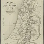
Kaart van het Heilige Land ten tijde van Josua en de Regteren

1 : 1100000 S.I. Mulder del. steend. v. C. W. Mieling [Leyden] : D. du Mortier & Fil. excud.
$title$

Afbeelding van 't land van Israël, naar deszelfs natuurlyke gesteltheid : waar in alle de zeën, rivieren en beeken, gelyk ook de bergen en dalen, de vlaktens, de woestynen, enz. dezes lands, die in de H.S. genoemt zyn, worden aangewezen

1 : 750000 door W.A. Bachiene J. van Jagen sculp. ; J.C. Philips fecit. te Gorinchem : by Nicolaas Goetzee
$title$

Schul-Atlas für die alte Erdbeschreibung : zur allgemeinen Schul-encyclopädie gehörig

J. H. Campe Zusammensetzung und Zeichnung von [...] Dufour, unter Leitung von Heusinger ; gestochen von Frentzel. Braunschweig : Schulbuchhandlung
$title$

Karte von Palaestina

1 : 1030000 Jeruzalém Klöden, Karl Friedrich von Mare, Carl bei August Rücker
$title$

Palaestina

Schul-Atlas der alten Welt bei Justus Perthes
$title$

Palestina čili Kanaan

Palestina Fried, Franz Luther, Th. nákladem Spolku Komenského
$title$

Aardrijkskundige, plaatsbeschrijvende en geschiedkundige kaart van Palestina of het Heilige land

1 : 281000 oorspronkelijk geteekend door J.T. Assheton [...] bijzonderlijk wat de teekening betreft naauwkeurig herz. en verb. door E. Maaskamp ; onder toezigt en medew. van [...] J. Clarisse Te Amsterdam : bij E. Maaskamp, thans het eigendom van J. C. van Kesteren, boekhandelaar en boekdrukker te Amsterdam
$title$

[Karte von Palästina]

1 : 500000 Palestina Leway, G.
$title$

Palestine.

1 : 1130000 Tanner, Henry S.
$title$

Palästina

Volksschul-Atlas über alle Teile der Erde Lange, Henry Druck und Verlag von Georg Westermann
$title$

Iudaea, seu Terra Sancta quae hebraeorum sive Israelitarum in suas duodecim tribus divisa, secretis ab invicem regnis Iuda, et Israel expressis insuper sex ultimi temporis ejusdem terrae provinciis

1 : 600000 Izrael Sanson, Guillaume Schenk, Pieter Pierre Schenk
$title$

Iudaea, seu Terra Sancta quae Hebraeorum sive Israelitarum in suas duodecim tribus divisa, secretis ab invicem regnis Iuda, et Israel expressis insuper sex ultimi temporis ejusdem terrae provinciis

1 : 600000 Izrael Sanson, Guillaume Schenk, Pieter Pierre Schenk
$title$

Palestine ou Terre Sainte.

1 : 610000 Lapie, M. (Pierre), 1779-1850
$title$

't Land Kanaan benevens Gilead verdeelt onder de XII stammen Israëls waar in de gelegendheid en uitgestrektheid van ieder erfdeel word aangewezen

1 : 700000 door W.A. Bachiene J. van Jagen mapp. sculpsit, et figur. apposit. sculpturam curavit ; J.C. Philips fecit. Uitgegeven te Gorinchem : by Nicolaas Goetzee
$title$

Nova totivs Palestinae sev Terrae Sanctae descriptio pagella vna ita vt bibliorvm volvminibvs congrvat

1 : 755000 Palestina Jenichen, Balthasar Ausfeld, Johann Carl
$title$

A map of Palestine or the Holy Land : with the division into tribes and provinces / by A.H. Dufour

1 : 1100000 Annotatie: Engraved for "Three years in the East". &a Dufour, Auguste Henri [S.l. : s.n.]
$title$

Cesta Israelitů z Egypta a cesty sv. Pavla

$title$

Regio Canaan seu Terra Promissionis, postea Iudaea vel Palaestina nominata, hodie Terra Sancta vocata

1 : 3000000 Kanaán Seutter, Matthäus Rogg, Gottfried per Matth. Seutter
$title$

Palestine.

1 : 1000000 Colton, G.W.
$title$

Palaestina

1 : 170000 Palestina
$title$

Palestine.

1 : 1650000 Monin, C.V.
$title$

La Palestine.

1 : 835000 Anville, Jean Baptiste Bourguignon d, 1697-1782
$title$

Palestine

1 : 1000000 Colton, G.W.
$title$

Palaestina.

1 : 1950000 Fenner, Rest.
$title$

Tabula Moderna Terre Sancte [Karte], in: [Clavdii Ptholomei Cosmographi ...], S. 311.

1 Karte aus Atlas Nicolaus Germanus [und Ptolemaeus, Claudius]
$title$

Palestine or Canaan

1 : 1
$title$

Terra Sancta : vita miraculis et passione Christi consecrata / autore N. Sanson Abbavilleo

1 : 3000000 Sanson, Nicolas [S.l. : s.n.]
$title$

The Madaba Map

Jeruzalém Survey of Israel
$title$

Karte des Heiligen Landes

1 : 310000 Izrael Möller, Arnold Wilhelm A.W. Möller
$title$

Palaestina

1 : 640000 Palestina Reichard, Christian Gottlieb Campius, D. a D. Campio
© MapTiler © OpenStreetMap contributors
How does it work?
These instructions will show you how to find historical maps online.
Getting started
Type the place name in the search box to find the exact location. You can further adjust the search by zooming in and out.
Zoom
Zoom in and out with the buttons or use your mouse or touchpad natively.
Exact Area tool
Click here and draw a rectangle over the map to precisely define the search area.
Set filters
Narrow your search with advanced settings, such as Years (from/to), Fulltext, Publisher, etc.
Results
See the results of your search on the right side. You can scroll down to find more maps of this location.
?

Download OldMapsOnline Mobile