Maps of Cádiz

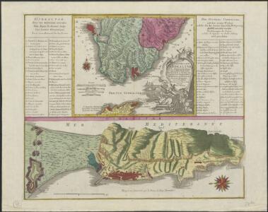
Castellum Gibraltar in Andalusia situm cum celebri freto inter Europam et Africam, annexis circumjacentibus portubus et castellis
1 : 470000 accurate designatum cura et sumptibus Tobiae Conradi Lotter Aug. Vindel : [T. Lotter]
Plan géometral de la montagne et de la ville de Gibraltar
1 Plan : Kupferdruck ; 33 x 15 cm, Bildgrösse: 34 x 47 cm Bonne; Chalmandrier; Longchamps chez les Freres Barthelemy, chez le Sr. Longchamps
Maroc (500 000 e). Tanger
1 : 500000 France. Service géographique de l'armée Service géographique de l'Armée
Carte nouvelle De L'ISLE de CADIX & du Detroit de GIBRALTAR
1 : 500000 Cádiz (Španělsko) Petit, Jean de Schneider, Ruprecht A. Weidler
Carte nouvelle de l'Isle de Cadix & du Detroit de Gibraltar
1 : 390000 Cádiz (Španělsko) Petit, Jean de aux depens des Heritiers du feu m. le docteur Homann

Accurata designatio celebris freti prope Andalusiæ castellum Gibraltar. inter in Europam et Africam
1 Karte : Kupferdruck ; 36 x 56 cm, Bildgrösse 48 x 56 cm Seutter Matthäus Seutter
Nouvelle carte du détroit de Gibraltar et de l'isle de Cadix
1 Karte : Kupferdruck ; 54 x 46 cm Santini; Remondini chez M.r Remondini
Plan topo-hydrographique du détroit de Gibraltar
1 Karte : Kupferdruck ; 44 x 53 cm Vezou; Lattré; Lynslager chez Lattré graveur rue St. Jacques vis-a-vis celle de la parcheminerie à la ville de Bordeaux
Carte nouvelle de l'isle de Cadix [et] du detroit de Gibraltar
1 Karte : Kupferdruck ; 55 x 47 cm Weidler; Petit; Schneider Homännische Erben
Carte générale du Maroc à l'échelle de 1 : 500 000 e. Tanger
1 : 500000 Maroc. Service géographique Rabat : Service géographique du Maroc
Mappa ou carta geographica dos reinos de Portugal e Algarve, 6
1 Blatt : 55 x 44 cm Dury
Des Koenigreichs Sevilla...

Castellum Gibraltar in Andalusia situm
1 Karte : Kupferdruck ; 26 x 32 cm, Bildgrösse 48 x 59 cm Lotter T. K. Lotter
Accurate Vorstellung der berühmten Meers-Enge bey Gibraltar
1 Karte : Kupferdruck ; 32 x 25 cm, Bildgrösse 47 x 56 cm Homännische Erben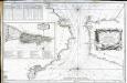
Carte du détroit de Gibraltar
1 Karte : Kupferdruck ; 56 x 87 cm Bellin s.n.
Tanger
1 : 250000 Larras, Nestor Prosper 18..-19..; France. Service géographique de l'armée Paris : H. Barrère
Castellum Gibraltar
1 : 470000 Gibraltar Lotter, Tobias Conrad sumptibus Tobiae Conradi Lotter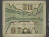
A chart of the STRAITS of GIBRALTER
from The sea-atlas : containing an hydrographical description of most of the sea-coasts of the known parts of the world.
Gibralter door de marquies d'villa Davias belegert
Gibraltar Schenk, Pieter P. Schenk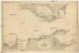
N-Atlantischer Ozean
1 : 100000 Atlantský oceán Reichs-Marine-Amt
Die Meerenge von Gibraltar
1 Karte : Kupferdruck ; 20 x 17 cm Kellner s.n.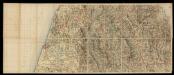
Mapa del norte de Marruecos
1 : 100000 1 full d'1 mapa en 12 fulls entelats de 2 en 2 fulls dins d'un estoig. Datat entre 1920 i 1930. [Cuerpo de Estado Mayor del Ejército?]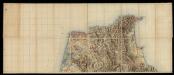
Mapa del norte de Marruecos
1 : 100000 1 full d'1 mapa en 12 fulls entelats de 2 en 2 fulls dins d'un estoig. Datat entre 1920 i 1930. [Cuerpo de Estado Mayor del Ejército?]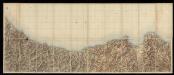
Mapa del norte de Marruecos
1 : 100000 1 full d'1 mapa en 12 fulls entelats de 2 en 2 fulls dins d'un estoig. Datat entre 1920 i 1930. [Cuerpo de Estado Mayor del Ejército?]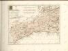

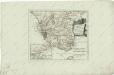
Mapa del Reyno de Granada construido sobre las mejores y mas modernas memorias
1 : 570000 por Thomàs Lopez, pensionista de S. M. Madrid : [Thomas Lopez]
Carte de la partie de l'Andalousie éprouvée par le tremblement de terre du 25 décembre 1884
1 : 600000 Wuhrer, L.