Maps of Aragón

Exactissima et plane nova tabula, in qua summa cura delineata invetus Arragoniae regissima et Navarrae, una cum Cataloniae principatu
1 : 1100000 per Jacobum Robyn Luggerdus van Anse schulp. Amsterdam : [s.n.]
Regna Hispaniarum, atque Portugalliæ, 2
1 Blatt : 53 x 63 cm Gerard Valck
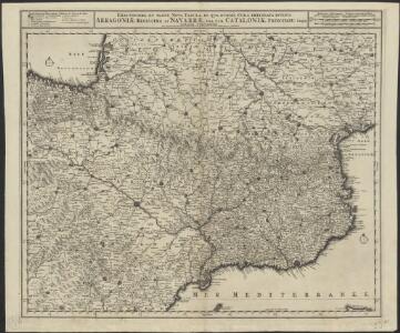
Exactissima et postomnes alias nunc demùm edita tabula continens perfectam descriptionem regnorum Arragoniæ et Navarræ, principatûs Cataloniæ
1 Karte : Kupferdruck ; 46 x 58 cm Ottens; Ottens R. et J. Ottens
Theatre de la guerre en Espagne [et]c
1 Blatt : 51 x 64 cm Covens et Mortier
[Spanien und Portugal in 4 Blättern]
Hand-Atlas über alle Theile der Erde und über das Weltgebäude Stieler, Adolf Justus Perthes
Carte generale des Monts Pyrénees, et partie des royaumes de France et d'Espagne / par le Sr. Roussel ; J.B. Delahaye scrip. ; A. Coquart fecit
1 : 270000 1 Mapa, col. Datació aproximada. Roussel ; Delahaye, J.B. ; Coquart, A. Dépôt des Fortifications
[Spanien und Portugal in 4 Blättern]
Hand-Atlas über alle Theile der Erde nach dem neuesten Zustande und über das Weltgebäude Stieler, Adolf bei Justus Perthes

A new Military Map of Spain and Portugal compiled from The Nautical Surveys of Don Vincent Tofiño, the new Provincial maps of Don Tomas Lopez, the large map of the Ptrenees by Roussill, and various original documents
1 Mapa en 4 seccions dins d'un estoig. John Stockdale J. Stockdale
[Spanien und Portugal in 4 Blättern]
Hand-Atlas über alle Theile der Erde nach dem neuesten Zustande und über das Weltgebäude Stieler, Adolf bei Justus Perthes
Spain = España : II
1 mapa. J. & C. Walker sculp. The Society for the Diffusion of Useful Knowledge; Charles Knight & Co
Les royaumes d'Aragon et de Navarre, partie des deux Castilles et du royaume de Valence
1 Karte : Kupferdruck ; 44 x 56 cm Jaillot; Dezauche chez Dezauche géog. rue des Noyers près celle des Anglois
Spanien, Portugal NW.
1 : 1800000 Berghaus, Heinrich; Flemming, Carl; Sohr, Karl; Theinert, A.
Arragonia et Catalonia
1 Karte : Kupferdruck ; 33 x 45 cm Mercator; Hondius Henricus Hondius
Arragonia [et] Catalonia
1 Karte : Kupferdruck ; 17 x 24 cm Mercator; Keere Cloppenburgh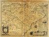
Arragonia et Catalonia
1 Karte : Kupferdruck ; 33 x 45 cm Hondius; Mercator Jodocus Hondius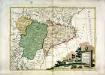
La Catalogna li regni di Aragona, ed Alta Navarra
1 Karte : Kupferdruck ; 28 x 38 cm Zatta presso Antonio Zatta
Spain. Espana II.
1 : 1800000 Society for the Diffusion of Useful Knowledge (Great Britain)
Royaumes d'Aragon et de Navarre, avec la principauté de Catalogne
1 : 7780000 Aragonie (Španělsko) Bonne, Rigobert André
[Spanien und Portugal, Blatt 2]
Adolf Stieler's Handatlas über alle Theile der Erde und über das Weltgebäude Stieler, Adolf Justus Perthes
[Spanien und Portugal in 4 Blättern, Blatt 2]
Handatlas über alle Theile der Erde und über das Weltgebäude Stieler, Adolf Justus Perthes

Spanische Halbinsel, Blatt 2.
1 : 1500000 Vogel, C.
Arragonia et Catalonia [Karte], in: Gerardi Mercatoris Atlas, sive, Cosmographicae meditationes de fabrica mundi et fabricati figura, S. 192.
1 Karte aus Atlas Mercator, Gerhard Montanus, Petrus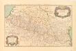
Les monts Pyrenées ou sont remarqués les passages de France en Espagne dressé sur les memoires les plus nouveaux
1 : 580000 Relief shown pictorially. Also names and shows small villages pictorially. Shows rivers, historic provinces, and boundaries. In French. Facsimile. Original version: Paris : Chez H. Iaillot, 1696 Sanson, Nicolas, 1600-1667 Madrid: Instituto Geográfico Nacional
Etats de la couronne d'Aragon
1 Karte : Kupferdruck ; 46 x 56 cm Robert de Vaugondy; Santini; Remondini chez Mr. Remondini
Etats de la couronne d'Aragon
1 Karte : Kupferdruck ; 47 x 58 cm Robert de Vaugondy G. et D. Robert de Vaugondy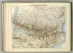
Carte Militaire des Pyrenees.
1 : 900000 Jouvet et Cie.
Aragonia et Catalonia
1 Karte : Kupferdruck ; 15 x 22 cm Lambert Andreae