Maps of Swabia

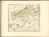
Partie septentrionale de la Souabe
1 : 280000 par Guillaume De L'Isle A Amsterdam : chez J. Covens et C. Mortier
Pars Sueviæ australior
1 Karte : Kupferdruck ; 46 x 61 cm L'Isle; Lotter apud Tobiam Conradum Lotter calcogr
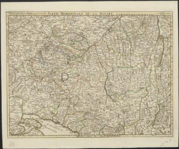
Partie meridionale de la Souabe
1 Karte : Kupferdruck ; 46 x 65 cm L'Isle; Ottens; Ottens chez R. et I. Ottens geogr
Partie meridionale de la Souabe
1 Karte : Kupferdruck ; 46 x 62 cm L'Isle; Renard chez l'auteur sur le quai de l'Horloge, chez L. Renard libraire prez de la bourse
Pars Sueviae Australior
1 : 250000 Mollova mapová sbírka Delisle, Guillaume Wolff, Jeremias
Pars Sueviae australior
1 : 310000 Württembersko (Německo) Delisle, Guillaume Lotter, Tobias Conrad T. C. Lotter
Nova Alemanniæ sive Sveviæ svperioris tabvla
1 Karte : Kupferdruck ; 36 x 47 cm Valck; Schenk apud G. Valk et P. Schenk
Geographica Sueviæ universæ descriptio, 4
2 Blätter : Homännische Erben
Alemannia sive Svevia Svperior
1 : 480000 Mollova mapová sbírka Hurter, Johann Christoph Blaeu, Joan I.
Nova Alemanniae sive Svevia Svperioris Tabvla
1 : 490000 Mollova mapová sbírka Hurter, Johann Christoph Janssonius, Johannes I
Alemaniae sive Sveviae Svperioris Chorographia nova
1 : 310000 Mollova mapová sbírka Hurter, Johann Christoph Custos, Raphael
Souabe Meridionale
1 : 240000 L'Isle, Guillaume de, 1675-1726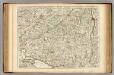
Souabe Meridionale.
1 : 240000 L'Isle, Guillaume de, 1675-1726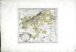
Die Markgrafschaft Burgau mit den Grafschaften Kirchberg und Weissenhorn
1 Karte : Kupferdruck ; 21 x 23 cm Reilly F. J. J. von Reilly
Nova Alemanniae Sive Sueviae Superioris Tabula. [Karte], in: Gerardi Mercatoris et I. Hondii Newer Atlas, oder, Grosses Weltbuch, Bd. 1, S. 241.
1 Karte aus Atlas Mercator, Gerhard und Hondius, Jodocus Jansson, Jan
Alemannia Sive Suevia Superior [Karte], in: Le théâtre du monde, ou, Nouvel atlas contenant les chartes et descriptions de tous les païs de la terre, Bd. 1, S. 266.
1 Karte aus Atlas Blaeu, Willem Janszoon und Blaeu, Joan Blaeu, Willem Janszoon
Alemannia Sive Suevia Superior [Karte], in: Novus Atlas, das ist, Weltbeschreibung, Bd. 1, S. 237.
1 Karte aus Atlas Blaeu, Joan Blaeu, Willem Janszoon
ALEMANNIA | SIVE | SVEVIA SVPERIOR
A. Christophoro Hurtero. [Amsterdam : Joan Blaeu]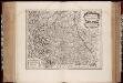
Alemannia sive Svevia svperior / a Christophoro Hurtero
1 : 500000 Annotatie: Origineel is Blad 120 in atlas factice; Annotatie geografische gegevens: Schaalstokken op kaart: Milliaria Alemanica quorum 12 um gradui respondent, en: Milliaria Germanica communia; West boven; Legenda linksonder: Expositio notarum Johann Christoph Hurter; Willem Jansz Blaeu 1571-1638 [Amsterdami] : [apud Guiljelmum Blaeu]
Alemannia Sive Suevia Superior [Karte], in: Theatrum orbis terrarum, sive, Atlas novus, Bd. 1, S. 280.
1 Karte aus Atlas Blaeu, Joan Blaeu, Willem Janszoon
Nova Alemanniae Sive Sueviae Superioris Tabula. [Karte], in: Novus atlas absolutissimus, Bd. 2, S. 217.
1 Karte aus Atlas Janssonius Offizin
Alemannia sive Suevia Superior
Hurter, Christoph
Nova Alemanniae sive Sveviae Svperioris Tabvla
Hondius, Henricus
[Exactissima Helvetiae, Rhaetiae, Valesiae ... tabula]
1 : 850000 9 Karten [Kopie von Adrian Braakman] [chez Pierre Schenk et Adrian Braakman], [Amsterdam]
Per Inclyti Circuli Suevici Supremorum Ordinum
1 : 160000 Mollova mapová sbírka Pfeffel, Johann Andreas Homann, Johann Baptista - dědici
Per Inclyti Circuli Suevici Supremorum Ordinum :
1 : 160000 Mollova mapová sbírka Pfeffel, Johann Andreas Pfeffel, Johann Andreas I.
Per Inclyti Circuli Suevici Supremorum Ordinum :
1 : 160000 Mollova mapová sbírka Pfeffel, Johann Andreas Homann, Johann Baptista - dědici
Per Inclyti Circuli Suevici Supremorum Ordinum :
1 : 160000 Mollova mapová sbírka Pfeffel, Johann Andreas Pfeffel, Johann Andreas I.