Maps of Schleswig-Holstein

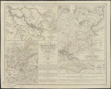
Die Gebiethe der vier freien Staedte Hamburg, Lübeck, Bremen und Frankfurt, nebst dem Freistaate Krakau
in vier Special Charten dargestellt von F. W. Streit L. Beyer sc. Nürnberg : Friedrich Campe
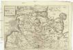
Holsatiae Descriptio. [Karte], in: Theatrum orbis terrarum, S. 208.
1 Karte aus Atlas Ortelius, Abraham Vrients, Jan Baptista
Holsatiae Descriptio. [Karte], in: Theatrum orbis terrarum, S. 120.
1 Karte aus Atlas Ortelius, Abraham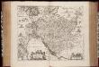
Ducatus Holsatiæ descriptio novissima / excudebant Janssonio-Waesbergii et Moses Pitt
1 : 365000 Annotatie: Origineel is Blad 82 in atlas factice; Annotatie geografische gegevens: Schaalstok: Die Maße der Teutsche Meilln, 3=5,9 cm; Rechtsboven: XLI Johannes Janssonius van Waesberge -1681?; Moses Pitt ca. 1654-1696 [Amstelodami : apud Ioannem Ianssonium]
Sect. 7: Hamburg, uit: Geologische Karte des Deutschen Reichs in 27 Blaettern / [von] Richard Lepsius ; Red. von C. Vogel
1 : 500000 Annotatie: Blad 18 ontbreekt; Een aantal bladen op linnen; Een aantal bladen gereviseerd 1913-1914; Annotatie geografische gegevens: Met schaalstokken o.a. in kilometers; Legenda Carl Vogel 1828-1897 Gotha : Justus Perthes
NOVA & ACCVRATISSIMA | DVCATVS | HOLSATIÆ | TABVLA
Auctore Joh. Meyer Husumensi. Matthias Und Clauß Petersen Goldtschmide gebr. Hus. sculps. [Amsterdam : Joan Blaeu]
Spezial - Karte von Schleswig - Holstein...
Ducatus Holsatiae Nova Tabula [Karte] Alluvies propè Detzbul [...] [Nebenkarte] Tabula Barmerensis [...] [Nebenkarte], in: Novus Atlas, das ist, Weltbeschreibung, Bd. 1, S. 114.
1 Karte aus Atlas Blaeu, Joan Blaeu, Willem Janszoon
Ducatus Holsatiae Nova Tabula [Karte] Alluvies propè Detzbul [...] [Nebenkarte] Tabula Barmerensis [...] [Nebenkarte] , in: Gerardi Mercatoris et I. Hondii Newer Atlas, oder, Grosses Weltbuch, Bd. 1, S. 109.
1 Karte aus Atlas Mercator, Gerhard und Hondius, Jodocus Jansson, Jan
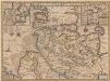
HOLSATIAE TABULA GENERALIS in qua sunt DUCATUS HOLSATIAE, DITHMARSIAE STORMARIAE et WAGRIAE
1 : 310000 Holštýnsko Wit, Frederick de Frederic de Wit
Holsatia ducatus [Karte], in: Gerardi Mercatoris Atlas, sive, Cosmographicae meditationes de fabrica mundi et fabricati figura, S. 146.
1 Karte aus Atlas Mercator, Gerhard Montanus, Petrus
Ducatus Holsatiae Nova Tabula [Karte] Alluvies propè Detzbul [...] [Nebenkarte] Tabula Barmerensis [...] [Nebenkarte], in: Le théâtre du monde, ou, Nouvel atlas contenant les chartes et descriptions de tous les païs de la terre, Bd. 1, S. 143.
1 Karte aus Atlas Blaeu, Willem Janszoon und Blaeu, Joan Blaeu, Willem Janszoon
Holsatia ducatus [Karte], in: Atlas, sive, Cosmographicae meditationes de fabrica mundi et fabricati figura, S. 141.
1 Karte aus Atlas Mercator, Gerhard
Ducatus Holsatiae Nova Tabula [Karte] Alluvies propè Detzbul [...] [Nebenkarte] Tabula Barmerensis [...] [Nebenkarte] , in: Novus atlas absolutissimus, Bd. 1, S. 143.
1 Karte aus Atlas Janssonius Offizin
Ducatus Holsatiae Nova Tabula [Karte] [Umgebung von Dagebul] [und] Tabula Barmorensis Meggerensis [...] [2 Nebenkarten], in: Theatrum orbis terrarum, sive, Atlas novus, Bd. 1, S. 177.
1 Karte aus Atlas Blaeu, Joan Blaeu, Willem Janszoon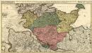
Holsatiae Ducatus, Vernaculè Das Hertzogtum Holstein
1 : 310000 Mollova mapová sbírka Visscher, Nicolaes Schenk, Peter II
Schleswig, Holstein, Lauenburg.
1 : 445000 Weiland, C. F. (Carl Ferdinand), d. 1847
General-Karte von den Herzogthümern Schleswig, Holstein und Lauenburg, den Füstenthümern Lübeck und Ratzeburg, und den freien und Hansestädten Hamburg und Lübek
1 : 450000 Dánsko Geerz, F. F. Geerz
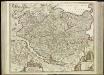
Saxonia Inferior
1 : 740000 Mollova mapová sbírka Pitt, Moses Pitt, Moses
Saxonia Inferior
1 : 740000 Mollova mapová sbírka Janssonius, Johannes Janssonius, Johannes I
Ducatus Holsatiae summâ diligentiâ accuratâq. censura noviter editus
1 : 569000 Holštýnsko Visscher, Claes Jansz. a Nicolao Iohanide Piscatore
Ducatus Holsatiae, summa diligentia accurataq. censura noviter editus
1 : 569000 Bad Segeberg (Německo) Visscher, Claes Jansz. a Nicolao Iohanide Piscatore
Tabula Generalis Holsatiae
1 : 310000 Mollova mapová sbírka Danckerts, Theodorus Danckerts, Theodor
Tabvla generalis Holsatiae complectens Holsatiae Dithmarsiae Stormariae et Vargiae dvcatvs
1 : 316000 Holštýnsko Homann, Johann Baptist a Ioh. Bapt. Homanno
[45][45] Holsatiae tabula generalis ..., uit: Atlas sive Descriptio terrarum orbis
Annotatie: Gedigitaliseerde versie. Amsterdam. Heiloo : Picturae (vervaardiger), 2015. tiff-bestand. Gedigitaliseerd: 07-01-2015; Origineel: Universiteitsbibliotheek Vrije Universiteit (XL.05127.-) ; Netherlands; Titelpagina ontbreekt Wit, Frederik de Amsterdam : Frederick de Wit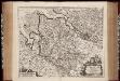
Ducatus Bremae et Ferdae, maximaeque partis ducatus Stormariae, comitatus Oldenburgi, Albis, Visurgisque fluminum novissima descriptio / per Nicolaum Visscher
1 : 350000 Annotatie: Origineel is Blad 80 in atlas factice; Met twee i.p.v. drie schaalstokken; Annotatie geografische gegevens: Met 3 schaalstokken Nicolaes Jansz Visscher sr 1618-1679 [Amsterdam : Nicolaus Visscher]
Holsatiae Dithmarsiae Stormariae et Vagriae Dvcatvs
1 : 480000 Mollova mapová sbírka Weigel, Christoph Kauffer, Michael Weigel, Christoph I.
Herzogthum Holstein im Nieder Sächsischen Creisse mit seinen abgetheilten Provintzien
Mollova mapová sbírka Weigel, Christoph Weigel, Christoph I.