Maps of Niedersachsen

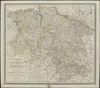
Neueste Karte vom Koenigreich Hannover nebst den beiden Herzogthümer Braunschweig-Wolfenbüttel und Holstein-Oldenburg
1 : 585000 Augsburg [etc.] : [Johannes Walch [etc.]
Post Karte des Königreichs Hannover und der angrenzenden Länder
1 : 790000 Dolní Sasko (Německo) Müller, Ignaz

Hannover
Grosser Hand-Atlas über alle Theile der Erde in 170 Karten Meyer, J. Verlag des Bibliographischen Instituts
Hannover, Braunschweig, Oldenburg, Bremen.
1 : 1000000 Flemming, Carl
Hannover, Braunschweig, Oldenburg und die Hansestädte
1 : 600000 Baltské moře-oblast Kiepert, Heinrich Gräf, C. Geographisches Institut
Straßen im Königreich Hannover 1848 (Auswahl)
Staat Hannover Straßennetz Kunz, Andreas ; Treiling, Thomas
Kleine Postkarte des Königreichs Hannover und der angrenzenden Länder
1 : 1300000 Dolní Sasko (Německo) Müller, Ignaz
Hannover, Braunschweig, Oldenburg.
1 : 600000 Ohmann, C. L.
Charte des Königreichs Hannover
Neuester Schul-Atlas Walch, Johann im Verlag bei Joh. Walch
Nova totius Westphaliae descriptio
1 : 804300 Vestfálsko (Německo) Visscher, Nicolaes Jansz. per Nicolaum Janßonium Vißcher
NOVA TOTIUS WESTPHALIAE DESCRIPTIO
1 : 800000 Vestfálsko (Německo) Visscher, Claes Jansz. per Nicolaum Janßonium Vißcher
Hannover.
1 : 505000 Radefeld, Carl Christian Franz, 1788-1874

Nordwest-Deutschland.
1 : 850000 Stein, Christ. Gottfr. Dan.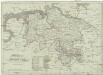
Koenigreich Hannover
1 : 1126000 Hannover (Německo) Tranquillo Mollo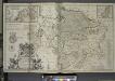
A new & exact map of the electorat of Brunswick-Lunenburg and ye rest of ye Kings Dominions in Germany.
from The world described, or, A new and correct sett of maps : shewing the kingdoms and states in all the known parts of the earth, with the principal cities, and most considerable towns in the world ... / ... by Herman Moll, geographer ...
Norddeutschland
Volksschul-Atlas über alle Teile der Erde Lange, Henry Druck und Verlag von Georg Westermann
Germany Northern.
1 : 990000 Hall, S. (Sidney)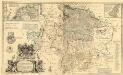
A New & Exact Map of the Electorate of Brunswick-Lunenburg and ye rest of ye Kings Dominions in Germany
1 : 510000 Mollova mapová sbírka Moll, Herman Overton, Philip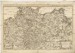
Le cercle de la Basse Saxe subdivisé en touts, les estats et principautés qui le composent
1 : 3090000 Braunschweig (Německo : historické území) Sanson, Nicolas Jean Cóvens et Corneille Mortier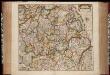
Nova totius Westphaliae descriptio / emendata a F. de Wit
1 : 860000 Annotatie: Origineel is Blad 73 in atlas factice Wit, Frederik de Amsterdam : Frederick de Wit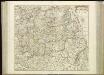
[59][59] Nova totius Westphaliae descriptio, uit: Atlas sive Descriptio terrarum orbis
Annotatie: Gedigitaliseerde versie. Amsterdam. Heiloo : Picturae (vervaardiger), 2015. tiff-bestand. Gedigitaliseerd: 07-01-2015; Origineel: Universiteitsbibliotheek Vrije Universiteit (XL.05127.-) ; Netherlands; Titelpagina ontbreekt Wit, Frederik de Amsterdam : Frederick de Wit
Electoratus Hanoverani cum ditionibus et praefecturis suis nova et accurata delin
1 : 596800 Dolní Sasko (Německo) Seutter, Matthäus Lotter, Tobias Conrad a Matth. Seuttero
Electoratus Hanoverani cum ditionibus et praefecturis suis nova et accurata delin
1 : 596800 Dolní Sasko (Německo) Seutter, Matthäus Lotter, Tobias Conrad a Matth. Seuttero
Electoratus Hanoverani cum ditionibus et praefecturis suis nova et accurata delin
Dolní Sasko (Německo) Seutter, Matthäus Lotter, Tobias Conrad a Matth. Seuttero

Nova totius Westphaliae Descriptio
1 : 810000 Mollova mapová sbírka Wit, Frederik de Wit, Frederick