Maps of Potsdam

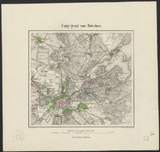
Umgegend von Potsdam
1 : 66666 gez[eichnet] v. L. Kraatz [...] Berlin : Reimer
Meßtischblatt 1906 : Potsdam (Nord), 1938
1 : 250000 Potsdam (Nord). - Hrsg. 1903, bericht. 1920, einz. Nachtr. 1936, redakt. Änd. [19]38. - 1:25000. - [Berlin]: Reichsamt für Landesaufnahme, 1938. - 1 Kt.
Meßtischblatt 1906 : Potsdam (Nord), 1936
1 : 250000 Potsdam (Nord). - Hrsg. 1903, bericht. 1920, einz. Nachtr. 1936. - 1:25000. - [Berlin]: Reichsamt für Landesaufnahme, 1936. - 1 Kt.
Meßtischblatt 1906 : Potsdam (Nord), 1935
1 : 250000 Potsdam (Nord). - Hrsg. 1903. - 1:25000. - [Berlin]: Reichsamt für Landesaufnahme, 1935. - 1 Kt.
Meßtischblatt 1906 : Potsdam (Nord), 1933
1 : 250000 Potsdam (Nord). - Hrsg. 1903, bericht. 1920, einz. Nachtr. 1933. - 1:25000. - [Berlin]: Reichsamt für Landesaufnahme, 1933. - 1 Kt.
Meßtischblatt 1906 : Potsdam (Nord), 1917
1 : 250000 Potsdam (Nord). - Aufn. 1901, hrsg. 1903, N.12, 617, Aufldr. 1917. - 1:25000. - [Berlin]: Reichsamt für Landesaufnahme, 1917. - 1 Kt.
Umgebung von Potsdam
Postdam
1 : 18000 Postupim (Německo) Meyer, Joseph der geographischen Anstalt des Bibliographischen Instituts
Plan von Potsdam und Umgegend
1 : 12000 Postupim (Německo) Möllendorf, Johann Karl Wolf Dietrich von Bimbé zu haben bei L. Fernabach junior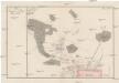
Plan der Situation des Dorfes Bornstedt
Bornstedt (Postupim, Německo)
Potsdam
Grosser Hand-Atlas über alle Theile der Erde in 170 Karten Meyer, J. Verlag des Bibliographischen Instituts
Grundriss von der Stadt Potsdam
Mollova mapová sbírka Schleuen, Johann David
Meßtischblatt 3644 : Potsdam, 1942
1 : 250000 Potsdam. - Aufn. 1901, hrsg. 1903, bericht. 1919, letzte Nachtr. 1940. - 1:25000. - [Berlin]: Reichsamt für Landesaufnahme, 1942. - 1 Kt.
Meßtischblatt 1974 : Potsdam (Süd), 1936
1 : 250000 Potsdam (Süd). - Hrsg. 1903, bericht. 1919, einz. Nachtr. 1936. - 1:25000. - [Berlin]: Reichsamt für Landesaufnahme, 1936. - 1 Kt.
Composite: 293. Potsdam.
1 : 100000 Reichsamt fur Landesaufnahme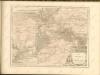

293. Potsdam.
1 : 100000 Reichsamt fur Landesaufnahme
Blatt V Potsdam, uit: Karte von Berlin und Umgebung in 12 Blättern
1 : 50000 Annotatie: Toelichtingen opgeborgen bij kaart; Annotatie geografische gegevens: Met schaalstokken: Meter, Schritt, geographische Meile Paul Schneider Berlin : Reichsamt für Landesaufnahme
Berlin (1944)
Germany. Berlin. Scale, 1: 59,000 (approx.). Copied from a German map dated 1931. G.S.G.S. (Misc.) No.168. [London] : War Office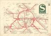
S Bahn

Blatt IX Werder, uit: Karte von Berlin und Umgebung in 12 Blättern
1 : 50000 Annotatie: Toelichtingen opgeborgen bij kaart; Annotatie geografische gegevens: Met schaalstokken: Meter, Schritt, geographische Meile Paul Schneider Berlin : Reichsamt für Landesaufnahme
Meßtischblatt 3545 : Teltow, 1953
1 : 250000 Teltow. - Hrsg. 1903, [bericht. 1935/36], [mehrfarb. hrsg. 1937], letzte Nachtr. 1940/42. - 1:25000. - [Berlin]: MdI, 1953. - 1 Kt.
Meßtischblatt 1907 : Teltow, 1934
1 : 250000 Teltow. - Hrsg. 1903, bericht. 1919, einz. Nachtr. 1934. - 1:25000. - [Berlin]: Reichsamt für Landesaufnahme, 1934. - 1 Kt.
Meßtischblatt 1907 : Teltow, 1919
1 : 250000 Teltow. - Aufn. 1901, bericht. 1919. - 1:25000. - [Berlin]: Reichsamt für Landesaufnahme, 1919. - 1 Kt.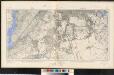
Meßtischblatt 1907/1908 (Doppelblatt) : Teltow/Schöneberg, 1919
1 : 250000 Teltow/Schöneberg. - Aufn. 1901, hrsg. 1903, Aufldr. 1919. - 1:25000. - [Berlin]: Reichsamt für Landesaufnahme, 1919. - 1 Kt.
Meßtischblatt 1907 : Teltow, 1901
1 : 250000 Teltow. - [Aufn. 1888?]. - 1:25000. - [Berlin]: Reichsamt für Landesaufnahme, 1901. - 1 Kt.
Meßtischblatt Sect. Teltow
1 : 250000 Sect. Teltow. - Aufgen. 1874, hrsg. 1877, einz. Nachtr. 1892. - 1:25000. - [Berlin]: Reichsamt für Landesaufnahme, 1892. - 1 Kt.
86. Berlin, Districts of Leipzig, Dresden, Karl-Marx-Stadt. The World Atlas.
1 : 1250000 USSR (Union of Soviet Socialist Republics).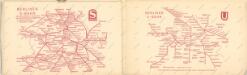
Taschenplan von Berlin