Maps of England

A travelling mapp of England containing the principall roads which are laid down with the comensurated distances
1 : 1330000 [...] by Philip Lea London : sold by Philip Lea Globe maker at the Atlas and Hercules in Cheap side neer Fryday Street end
England and Wales.
1 : 1725000 Teesdale, Henry
Composite: (Cary's England, Wales, and Scotland).
1 : 360000 Cary, John, ca. 1754-1835
County Map Of England, And Wales.
1 : 2400000 Mitchell, Samuel Augustus
Composite: England and Wales.
1 : 900000 Hughes, William
61-62. England and Wales. The World Atlas.
1 : 1250000 USSR (Union of Soviet Socialist Republics).
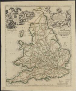
A new and correct map of the roads in England and Wales wherein are contained all the road waies and the principal cross roads, with the computed distances [...] &c.
1 : 1300000 ingraven by Sutton Nicholls London : printed and sold by H. Overton at the White Horse without Newgate
A new map containing all the citties, market townes, rivers, bridges, & other considerable places in England & Wales, wherein are delineated ye roads from towne to towne, & ye number of reputed miles between them, are given by inspection without scale or compas [...]
1 : 1250000 London : sold by Rob: Walton at ye Globe [...] & by Rob: Morden at ye Atlas in Corn-hill
England And Wales.
1 : 2850000 Finley, Anthony
Great Britain
A new general atlas of modern geography, consisting of a complete collection of maps of the four quarters of the globe Wyld, James James Wyld
England, Wales.
1 : 1800000 Flemming, Carl
England and Wales.
1 : 2700000 Lucas, Fielding Jr.
England, Wales.
1 : 2700000 Darton, William
England.
1 : 1760000 Mitchell, Samuel Augustus
England.
1 : 1760000 Mitchell, Samuel Augustus
Accuratissima Angliæ regni et Walliæ principatus descriptio
1 Karte : Kupferdruck ; 57 x 47 cm Wit ex officina I. Cóvens et C. Mortier
Accuratissima Angliæ regni et Walliæ principatus descriptio
1 Karte : Kupferdruck ; 57 x 47 cm Wit Frederick de Wit

Smith's new map of England and Wales with parts of Scotland : including the turnpike, and principal crossroads ... / engraved by Edw[ar]d Jones & Benj[ami]n Smith
1 : 1275000 Jones, Edward (fl. 1806); Smith, Benjamin London : C. Smith
England.
1 : 1900000 Radefeld, Carl Christian Franz, 1788-1874
Le royaume d'Angleterre
1 Karte : Kupferdruck ; 55 x 47 cm Le Rouge; Basset; Basset chez Basset rue St. Jacques
Le royaume d'Angleterre
1 Karte : Kupferdruck ; 55 x 47 cm Le Rouge; Basset; Basset chez Basset rue St. Jacques
Britanniæ sive Angliæ regnum
1 Karte : Kupferdruck ; 56 x 48 cm Lotter Tobias Konrad Lotter
Le royaume d'Angleterre
1 Karte : Kupferdruck ; 55 x 47 cm Le Rouge Georges Louis Le Rouge rue des Augustins
Britanniæ sive Angliæ regnum
1 Karte : Kupferdruck ; 56 x 48 cm Seutter Matthäus Seutter
Anglia Cambdeni
1 Karte : Kupferdruck ; 38 x 32 cm Camden; Weigel; Kauffer Christoph Weigel
Magnæ Britanniae pars meridionalis, in qua regnum Angliæ
1 Karte : Kupferdruck ; 55 x 47 cm Homann; Visscher Johann Baptist Homann
Nouvelle carte de l'Angleterre
1 Karte : Kupferdruck ; 45 x 47 cm, Gesamtgrösse 45 x 63 cm Châtelain s.n.
Anglia in septem anglo-saxonum regna
1 Karte : Kupferdruck ; 53 x 47 cm Schenk Pieter Schenk
A new mapp of the kingdome of England
1 Karte : Kupferdruck ; 57 x 50 cm printed and given out by Nicolas Visscher upon the Dam at the signe of the fisher, by Iohn Overton at the white horse without Newgate
A new mapp of the kingdome of England
1 Karte : Kupferdruck ; 57 x 50 cm printed and given out by Nicolas Visscher upon the Dam at the signe of the fisher, by Iohn Overton at the white horse without Newgate
Anglia regnum in omnes suos ducatus, comitatus, et provincias divisum
1 Karte : Kupferdruck ; 57 x 48 cm Wit Frederick de Wit
Angliæ regni florentissimi nova descriptio
1 Karte : Kupferdruck ; 38 x 45 cm Lhuyd; Ortelius s.n.