Maps of Northern European Plain

Das europaeische Russland
1 : 6500000 entworfen von C.F. Weiland C.J. Maedel sen. sc. Weimar : im Verlage des Geographischen Instituts
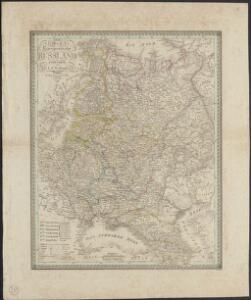
Europaeisches Russland mit Kasan, Astrachan und Georgien
Schul-Atlas über alle Theile der Erde nach dem neuesten Zustande, und über das Weltgebäude Stieler, Adolf bei Justus Perthes
Europäisches Russland

Russland
Russland / Europäischer Teil Skizzenbuch
Das europäische Russland
1 : 6588000 Rusko Gräf, Carl Geographisches Institut
Russia.
1 : 7760000 Johnson, A.J.
Russia.
1 : 7760000 Johnson, A.J.
Europäisches Russland
1 : 20500000 Russland / Europäischer Teil
Europäisches Russland
1 : 5000000 Rusko západní Handtke, Friedrich Carl Flemming, Verlag, Buch- und Kunstdruckerei
La Russie d'Europe
Russland Bielaerts, J. B.
Russisches Reich. Verwaltungsgrenzen von 1914. Europäischer Teil
Russland / Europäischer Teil Verwaltungsgliederung
Tabvla Rvssiæ / ex autographo, quod delineandum curavit Foedor filius tzaris Boris desumta; et ad f
1 : 9000000 1 Karte : Kupferdruck ; 41 x 53 cm Fëdor excusum apud Guiljelmum Blaeu
Tabula Russiae ex autographo, quod delineandum curavit Foedor filius Tzaris Bori et ad fluvios Dwina
1 : 1100000 1 Karte : Kupferdruck ; 27 x 34 cm [Matthäus Merian d. Ältere]
TABVLA | RVSSIÆ | ex autographo, quod delineandum | curavit Foedor filius Tzaris Boris desum- | ta; et ad fluvios Dwinam, Zuchanam, aliaque | loca, quantum ex tabulis ex notitiis ad nos dela- | tis fieri potuit, amplificata...
Amstelodami, | Excusum Apud Guiljelmum Blaeu
Russland
1 : 15000000 Evropa východní Kocen, Blaž Eduard Hölzel
Europäisches Russland 1801-1855
1 : 15500000 Russland / Europäischer Teil
Karte der Vergrösserungen Russlands unter Peter dem Grossen und seinen Nachfolgern
Russland Peter I.
Europäisches Russland
1 : 14500000 Russland / Europäischer Teil
Europaeisches Russland mit Kasan, Astrachan und Georgien
Russland / Europäischer Teil
Des Russischen Reichs Europäischer Theil
Stieler's Hand-Atlas Stieler, Adolf bei Justus Perthes
Russland
1 : 15000000 Russland / Europäischer Teil

Ruszland
1 : 18000000 Russland / Europäischer Teil
Russland
1 : 16000000 Russland / Europäischer Teil
Karte der Vergrösserungen Russlands unter Peter dem Grossen und seinen Nachfolgern
Russland Peter I.
Das Europaeische Russland
Russland / Europäischer Teil
Russland
Russland / Europäischer Teil
Ravensteinkarte Osteuropa
1 : 3333333 Evropa střední a východní Ravensteins Geographische-Verlagsanstalt und Druckerei
Composite: Das Russische Reich in Europa.
1 : 4475000 Stein, Christ. Gottfr. Dan.