Maps of Svealand

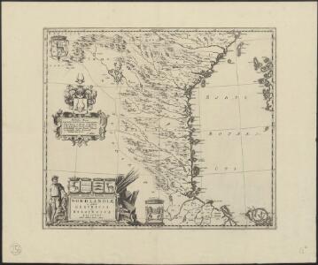
Nordlandiae et quibies Gestricia et Helsingicae regiones
1 : 1285000 auctore Andrea Buraeo Sueco [Amsterdam] : J. Blaeu
NORDLANDIÆ | et quibies | GESTRICIA | et | HELSINGICÆ | REGIONES
Auct. Andrea Buræo Sueco. [Amsterdam : Joan Blaeu]
SUEONIA | Proprie sic dicta
Auctore Andrea Buræo. [Amsterdam : Joan Blaeu]
Karta öfver Swearike och norra delen af Swerige
1 : 720000 författad af C.P. Hällström S. Anderson sc. [Stockholm] : Geografiska Inrättningen
Norge 55-2: Accurat landcaart over Norges Rige anden Part
1 : 300000 G. Bordin
Norge 55-3: Accurat landcaart over Norges Rige anden Part
1 : 300000 G. Bordin
Spesielle kart 41: Oversigtskroki over projekterede Banelinier Flisen-Halsjøen-Støa-Orsa
1 : 200000
Vonsjøen
1 : 250000
Ljørdalen
1 : 250000
Ostsee
1 : 200000 Alandské ostrovy (Finsko : souostroví) Reichs-Marine-Amt
Finnskog
1 : 250000
Dale Carliae et Westmanniae, Nova et Accurata descriptio. [Karte], in: Novus atlas absolutissimus, Bd. 1, S. 64.
1 Karte aus Atlas Janssonius Offizin
XII
1 : 400000 N. Franck
XII
1 : 400000 N. Franck
IX
1 : 400000 L. Arentz
XV
1 : 400000 R. Haavin
IX
1 : 400000 L. Arentz
IX
1 : 400000 L. Arentz
Ostsee
1 : 200000 Baltské moře Reichs-Marine-Amt
XV
1 : 400000 R. Haavin
Norge 55-7: Accurat landcaart over Norges Rige anden Part
1 : 300000 G. Bordin
Spesielle kart 11: Oversigtskart og Profil over den projecterede Jernbanelinie fra Trondhjem til Jemtland over Meraker
1 : 400000 C. Collett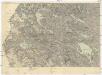
Östersund - Storlien
1 : 200000 Östersund (Švédsko) Generalstabens Litografiska Anstalt
Finnskog
1 : 250000
Ostsee
1 : 200000 Baltské moře Reichs-Marine-Amt
Vera
1 : 250000
Geologiske kart 121-P: Kart med magnetisk totalfelt. Torsby
1 : 250000 Norges geologiske undersøkelse
Kartblad 163 øst: Det Elverumske Skjeløber Compagnie; østre del

Ostsee
1 : 200000 Baltské moře Reichs-Marine-Amt