Maps of Europe

General Karte von Europa, worinnen die Gestalt dieses Erdtheiles zu ersehen ist, wie selbe nach seinem Höhensisteme und Wasserzuge angeordnet ist
1 : 9500000 entworfen von Freyherrn v. Sorriot [...] gestochen v. J. List Wien, [s.n.]
[Verbreitung der Mammalia oder Säugethiere in Europa]
Zweiter Band, enthaltend in vier Abtheilungen die Vertheilung der Organismen: 5. Pflanzen-Geographie, 6. Thier-Geographie, 7. Anthropographie, 8. Ethnographie Humboldt, Alexander von Verlag von Justus Perthes
Handelskaart van Europa : ten dienste van het onderwijs / door J.J. ten Have
1 : 3333000 Annotatie: Met handelsprodukten en belangrijke handelsroutes J.J. ten Have 's-Gravenhage : Ykema
Neueste Karte von Europa
Grosser Hand-Atlas über alle Theile der Erde in 170 Karten Meyer, J. Verlag des Bibliographischen Instituts
Europa
Adolf Stieler's Handatlas über alle Theile der Erde und über das Weltgebäude Stieler, Adolf Justus Perthes
Europa mit politischer Begränzung der einzelnen Staaten
Stieler's Hand-Atlas Stieler, Adolf bei Justus Perthes
Charte von Europa
1 Karte : Kupferdruck ; 46 x 56 cm im Verlage des Industrie-Comptoirs
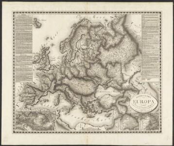
General Karte von Europa
1 Karte : Kupferdruck ; 50 x 58 cm von der K. K. privileg: Schneider und Weigelschen Kunst= und Buchhandlung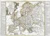
L'Europe
1 Karte : Kupferdruck ; 46 x 51 cm Nolin; Longchamps; Basset; Basset chez Basset rue Jacques au coin de celle des Mathurins
Charte von Europa
1 Karte : Kupferdruck ; 38 x 47 cm Güssefeld zu finden bey C. Weigel u. Schneider
Charte von Europa
1 Karte : Kupferdruck ; 38 x 48 cm Güssefeld zu finden bey C. Weigel u. Schneider
Charte von Europa
1 Karte : Kupferdruck ; 38 x 47 cm Güssefeld zu finden bey C. Weigel u. Schneider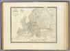
L'Europe.
1 : 12800000 Andriveau-Goujon, J.
Europa zur Uebersicht der Flussgebiete und Höhenzüge
Stieler's Hand-Atlas Stieler, Adolf bei Justus Perthes
Europe.
1 : 24000000 Darton, William
Florenkarte von Europa
Atlas der Pflanzenverbreitung Drude, Oscar Justus Perthes
Europa
Hand-Atlas über alle Theile der Erde und über das Weltgebäude Stieler, Adolf Justus Perthes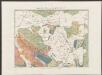
Europa ad magnae Europae Gerardi Mercatoris P. imitationem [...] [Karte], in: Gerardi Mercatoris Atlas, sive, Cosmographicae meditationes de fabrica mundi et fabricati figura, S. 61.
1 Karte aus Atlas Mercator, Gerhard Montanus, Petrus
Europa
Schul-Atlas in 36 Karten Völter, Daniel Verlag der J.M. Dannheimer'schen Buchhandlung
Europa, Staatenkarte
1 : 25000000 Europa
Europa mit politischer Begränzung der einzelnen Staaten
Hand-Atlas über alle Theile der Erde nach dem neuesten Zustande und über das Weltgebäude Stieler, Adolf bei Justus Perthes
Europa
Atlas der Geologie Zittel, K.v. ; Berghaus, Hermann Justus Perthes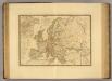
Europe d'apres les derniers traites de paix.
1 : 12400000 Picquet, C.
Composite: Europe.
1 : 4800000 Kitchin, Thomas
Europa
Schul-Atlas über alle Theile der Erde nach dem neuesten Zustande, und über das Weltgebäude Stieler, Adolf Justus Perthes
Europa
1 Karte : Kupferdruck ; 46 x 53 cm Haas Homännische Erben
Karte von Europa
1 Karte : Kupferdruck ; 25 x 29 cm Sotzmann; Schmidt s.n.
Europa
Neuer Handatlas über alle Theile der Erde Kiepert, Heinrich Verlag von Dietrich Reimer
Charte von Europa
1 Karte : Kupferdruck ; 38 x 47 cm Güssefeld zu finden bey C. Weigel u. Schneider