Maps of Europe
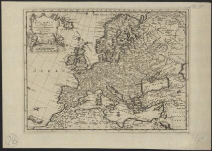
L'Europe, suivant les nouvelles observations de Messrs. de l'Academie Royale des Sciences, etc.
1 : 5100000 augmentées de nouveau Leyde : chez Pierre van der Aa
EVROPA
recens descripta | à | Guilielmo Blaeuw. [Amsterdam : Joan Blaeu]
Europa Exactissime Descripta [Karte], in: Gerardi Mercatoris et I. Hondii Newer Atlas, oder, Grosses Weltbuch, Bd. 1, S. 30.
1 Karte aus Atlas Mercator, Gerhard und Hondius, Jodocus Jansson, Jan
Europe : laid down from the observations of the Royal Academy of Sciences & compared with the maps of Sanson, Nolin, Du Fer, De l'Isle, Moll & other modern geographers ... / [John Bowles] ; engrav'd by Emanuel Bowen
1 : 4500000 Annotatie: Met tabel van Europese lengtematen; Met informatie over de verschillende Europese staten Bowles, John; Bowen, Emanuel London : printed for John Bowles
Carte demonstrative des determinations astronomiques de latitude et d'azimuth
1 : 10000000 Institut topographique militaire
Europa Exactissime Descripta [Karte], in: Novus atlas absolutissimus, Bd. 1, S. 25.
1 Karte aus Atlas Janssonius Offizin
Europa 1964
Europa Kunz, Andreas ; Moeschl, Joachim Robert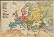
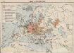
Völkerkarte von Europa
1 : 36000000 Europa Ethnische Gruppe
Europa 1804
Europa Kunz, Andreas ; Moeschl, Joachim Robert
Europa nach seinen kirchlichen Verhältnissen im Mittelalter
1 : 15000000 Europa Kirchengeschichte
Europa 1881
Europa Kunz, Andreas ; Röss, Wolf ; Moeschl, Joachim Robert
Europa
[Allgemeiner Atlas über alle Theile der Erde in 29 Blättern] Ziegler, Jakob Melchior Top. Anstalt v. J. Wurster u. Comp.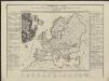
Neue Carte von Europa welche die merkwürdigsten Producte und vornehmsten Handelspläze nebst den Flächen-Inhalt aller Europäischen Länder in deutschen Quadrat-Meilen enthält
1 : 9000000 von A.F.W. Crome T.A. Pingeling sculpsit Hamburg Dessau ; [s.n.]
Europa Übersicht der politischen Verhältnisse und Hauptverkehrswege
1 : 20000000 Europa Verkehrsnetz
Europa 2008
Europa Kunz, Andreas ; Moeschl, Joachim Robert
Florenkarte von Europa
Atlas der Pflanzenverbreitung Drude, Oscar Justus Perthes
[Recto], uit: Europa exactissime descripta / auctore Henrico Hondio
1 : 11500000 Annotatie: Uit: L'appendice de l'atlas de Gerard Mercator et Iudocus Hondius ... - Amsterdam : Henry Hondius, 1633; Met opdracht aan Lodewijk XIII Hondius, Henricus Amstelodami : sumptibus auctoris
Carte Geologique De L'Europe.
1 : 3800000 Dumont, Andre
Europa 1861
Europa Kunz, Andreas ; Röss, Wolf ; Moeschl, Joachim Robert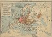
Das Deutschtum in Europa
1 : 36000000 Europa Ethnische Gruppe, Deutsche
[Botanisch-Geographisch-Statistische Karte von Europa]
Zweiter Band, enthaltend in vier Abtheilungen die Vertheilung der Organismen: 5. Pflanzen-Geographie, 6. Thier-Geographie, 7. Anthropographie, 8. Ethnographie Humboldt, Alexander von Verlag von Justus Perthes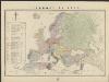
L'Europe en 1860
1 : 7800000 London : Edward Stanford
Europa 1878
Europa Kunz, Andreas ; Röss, Wolf ; Moeschl, Joachim Robert
Europa 1885
Europa Kunz, Andreas ; Röss, Wolf ; Moeschl, Joachim Robert
Nova Europae Descriptio [Karte], in: Gerardi Mercatoris Atlas, sive, Cosmographicae meditationes de fabrica mundi et fabricati figura, S. 64.
1 Karte aus Atlas Mercator, Gerhard Montanus, Petrus
Handelskaart van Europa : ten dienste van het onderwijs / door J.J. ten Have
1 : 3333000 Annotatie: Met handelsprodukten en belangrijke handelsroutes J.J. ten Have 's-Gravenhage : Ykema
Hyetographic or Rain Map of Europe
The physical atlas Johnston, Alexander Keith William Blackwood & Sons
Europa 1867
Europa Kunz, Andreas ; Röss, Wolf ; Moeschl, Joachim Robert
Nouvelle carte de l'Europe dans son état actuel
Evropa Hérisson, Eustache Desray chez Desray