Maps of Maluku

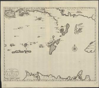
Kaart van de zuyd-ooster eylanden van Banda
1 : 2200000 [Dordrecht etc.] : J. van Braam en G. Onder de Linden exc.
Partie, Nouvelle Hollande. Oceanique no. 29.
1 : 1641836 Vandermaelen, Philippe, 1795-1869
Geologische overzichtskaart van den Nederlandsch Oost-Indischen Archipel : Aroe-, Kei- en Tenimbereilanden / bewerkt door J. Zwierzycki
Landsdrukkerij Weltevreden (Batavia) [Weltevreden (Batavia) : Landsdrukkerij]
Kaart van een gedeelte der zuid en zuidwest kust van Nieuw-Guinea : volgens de opnemingen gedaan door Zr. Ms. schepen Dourga, Triton, Sireen en Postillon tusschen de jaren 1826 en 1835 / zamengesteld door Salomon Müller
[S.l. : s.n.]
Banda / U.S. Army Map Service
U.S. Army Map Service Washington D.C. Washington D.C. : U.S. Army Map Service
Timor-Zee / Topografische Dienst
Topografische Dienst Batavia Batavia : Reproductiebedrijf Topografische Dienst
Aroe-Eilanden / samengesteld en gedrukt bij den Topografischen Dienst
Topografische Dienst Batavia Batavia : Topografische Dienst
Aroe Eilanden / U.S. Army Map Service
U.S. Army Map Service Washington D.C. Washington D.C. : U.S. Army Map Service
De landvoogdy van Amboina met de elf onderhoorige eylanden
1 : 150000 [Dordrecht etc.] : [J. van Braam & G. Onder de Linden]
Kaart der Molukken / [J.W. Stemfoort en J.J. ten Siethoff ; gereproduceerd op last van het Departement van Koloniën, aan de Topographische Inrichting te 's-Gravenhage, onder leiding van den Directeur C.A. Eckstein]
Ministerie van Koloniën Den Haag s-Gravenhage : Departement van Koloniën
Bladwijzer van Ceram : schaal 1:100.000
[S.l. : s.n.]
[Tanimbar]
[S.l. : s.n]
Noord-Jamdena / samengesteld door den Topografische Dienst (Kart[ografische] Afd[eling]) naar diverse gegevens
Topografische Dienst Batavia Batavia : Reproductieberijf Topografische Dienst
Gouv[ernement] der Molukken (Res[identie] Ambon) / Topografische Dienst, Weltevreden (Batavia)
[S.l. : s.n.]
Aroe Islands / Australian Survey Corps
Australian Survey Corps [S.l.] : Australian Survey Corps
Kaimana / Netherlands Topographic Service
Netherlands Topographic Service Delft [Delft] : Netherlands Topographic Service
[Kaart der Ambonse Eilanden]
[S.l. : s.n.]
Etna-Baai / Netherlands Topographic Service
Netherlands Topographic Service Delft [Delft] : Netherlands Topographic Service
Etna Baai / prepared under the direction of the Chief Engineer by Base Map Plant U.S. Army, June 1944
Corps of Engineers U.S. Army War Department Washington D.C. [S.l.] : Corps of Engineers U.S. Army, War Department
Schetskaart Etna-Baai / Topografische Dienst
Topografische Dienst Batavia Batavia : Topografische Dienst
Keij of Ewaf Eilanden / voor het Kon. Ned. Aardrijksk. Genootschap trigonometrisch opgenomen door H.O.W. Planten ; geassisteerd door A. Buij 1889-1890
1 : 150000 Annotatie: Bijlage bij: Tijdschrift van het Koninklijk Nederlandsch Aardrijkskundig Genootschap, Tweede Serie, dl. 9 (1892), p. 619-653 (kaart XVII) Planten, H. O. W.; Buij, A. Leiden : Brill
Teloek Sebakor Baai / Survey Directorate H[ead] Q[uarters] SEALF [=South East Asia Land Forces]
Survey Directorate Head Quarters South East Asia Land Forces [S.l.] : Survey Directorate H[ead] Q[uarters] SEALF [=South East Asia Land Forces]
Nabire / Netherlands Topographic Service
Netherlands Topographic Service Delft [Delft] : Netherlands Topographic Service
Teloek Sebakor-Baai / Netherlands Topographic Service
Netherlands Topographic Service Delft [Delft] : Netherlands Topographic Service
Nabire / Survey Directorate H[ead] Q[uarters] ALFSEA [=American Land Forces South East Asia]
Survey Directorate Head Quarters American Land Forces South East Asia [S.l.] : Survey Directorate H[ead] Q[uarters] ALFSEA [=American Land Forces South East Asia]
Charles Louis-Gebergte / prepared under the direction of the Chief Engineer by Base Map Plant USAFFE, July 1943
Base Map Plant USAFFE [S.l.] : Base Map Plant USAFFE
Charles Louis-Gebergte / Netherlands Topographic Service
Netherlands Topographic Service Delft [Delft] : Netherlands Topographic Service
Schetskaart van de ligging van het voor kolonisatie geschikte terrein aan de Geelvinck-Baai (=Geelvink-Baai)
[S.l. : s.n.]
Schetskaart Charles Louis-gebergte / Topografische Dienst
Topografische Dienst Batavia Batavia : Topografische Dienst