Maps of Noord-Brabant

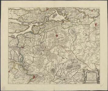
Brabantiae pars septentrionalis continens marchionatus S. Rom. Impery, Bergozomanum, comitatus Hoochstratensem, Cantacrucianum, Oelamum, baroniam Bredanam, territoria Ryense, Herentaliae etc. Amstelodami sumptibus F. de Wit.
1 : 170000 [Amsterdam] : apud I. Cóvens et C. Mortier
Brabantiae Pars Septentrionalis [...] [Karte], in: Gerardi Mercatoris et I. Hondii Newer Atlas, oder, Grosses Weltbuch, Bd. 1, S. 378.
1 Karte aus Atlas Mercator, Gerhard und Hondius, Jodocus Jansson, Jan
[116][119] Brabantiae pars septentrionalis ..., uit: Atlas sive Descriptio terrarum orbis
Annotatie: Gedigitaliseerde versie. Amsterdam. Heiloo : Picturae (vervaardiger), 2015. tiff-bestand. Gedigitaliseerd: 07-01-2015; Origineel: Universiteitsbibliotheek Vrije Universiteit (XL.05127.-) ; Netherlands; Titelpagina ontbreekt Wit, Frederik de Amsterdam : Frederick de Wit
Le Brabant Hollandois et Partie du Comté de Hollande &c.
1 : 260000 Mollova mapová sbírka Nolin, Jean-Baptiste Nolin, Jean Baptiste
Brabantiae pars septentrionalis
1 : 172000 Brabantsko Hondius, Henricus H. Hondii
Brabantiae pars septentrionalis
1 : 170000 Brabantsko Hondius, Henricus sumptibus Henrici Hondy
Le Duché De Brabant. qui comprend les Quartiers de Louvain, Brusselles, Anvers, Et Bosleduc. [...] [Karte], in: Atlas nouveau, contenant toutes les parties du monde [...], Bd. 2, S. 27.
1 Karte aus Atlas Sanson, Nicolas Jaillot, Alexis Hubert und Mortier, Pieter
Le Brabant Espagnol qui comprend les Quartiers de Bruselles, de Louvain et partie de celuy d'Anvers
1 : 260000 Mollova mapová sbírka Sanson, Guillaume Jaillot, Alexis Hubert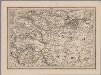
[14], uit: Hydro-Oro und Chorographische General Karte des Koenigreichs der Niederlande und der angrenzenden Länder bis Paris : mit der Angabe der Kunst und Heer-Strassen und der Entfernung der Poststationen / ... zusammengetragen und reducirt von ... Wilhelm Müller
1 : 400000 titelvariant: Generalkarte des Koenigreichs Hannover; Annotatie: 1e supplement bij: Generalkarte des Koenigreichs Hannover (1818) Müller, Wilhelm (fl. 1818) [Hannover : Wilhelm Müller]
Tertia Pars Brabantiae qua continetur Marchionats. S.R.I. horum urbs primaria Antverpia [Karte], in: Novus atlas absolutissimus, Bd. 3, S. 50.
1 Karte aus Atlas Janssonius Offizin
Tertia Pars Brabantiae qua continetur Marchionat. S.R.I. horum urbs primaria Antverpia [Karte], in: Novus Atlas, das ist, Weltbeschreibung, Bd. 1, S. 322.
1 Karte aus Atlas Blaeu, Joan Blaeu, Willem Janszoon
Tertia Pars Brabantiae qua continetur Marchionat. S.R.I. horum urbs primaria Antverpia [Karte], in: Le théâtre du monde, ou, Nouvel atlas contenant les chartes et descriptions de tous les païs de la terre, Bd. 1, S. 349.
1 Karte aus Atlas Blaeu, Willem Janszoon und Blaeu, Joan Blaeu, Willem Janszoon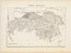
Noord-Brabant, uit: Sterfte-atlas van Nederland over 1860-1874 / [uitgave van de Nederlandsche Maatschappij tot Bevordering der Geneeskunst]
titelvariant: Sterfte-atlas van Nederland; Annotatie: Alleen kaartbijlage aanwezig Pieter Harmen Witkamp 1816-1892; Nederlandsche Maatschappij tot Bevordering der Geneeskunst Amsterdam : van Rossen
Tertia Pars Brabantiae quae continetur Marchionat. S.R.I. horum urbs primaria Antverpia [Karte], in: Theatrum orbis terrarum, sive, Atlas novus, Bd. 1, S. 343.
1 Karte aus Atlas Blaeu, Joan Blaeu, Willem Janszoon
TERTIA PARS | BRABANTIÆ | qua continetur | MARCHIONAT. S.R.I. | horum urbs primaria | ANTVERPIA
Ex Archetypo | Michaelis Florentij a Langren | Reg. Maj. Mathematico. Guiljelmus Blaeu excudit
Tertia pars Brabantiae qua continetur Marchionat. S. R. I. horum urbs primaria Antverpia
1 : 172000 ex archetypo Michaelis Florentii a Langren Guiljelmus Blaeu excudit [Amsterdam] : Blaeu
Le Brabant Hollandois qui comprend Quartier de Bos-le-Duc, le Marquisat de Berg-Op-Zoom, et la Baronie de Breda
1 : 240000 Mollova mapová sbírka Sanson, Guillaume Jaillot, Alexis Hubert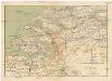
Zeeland en Noord-Brabant
1 : 300000 Brabantsko Seyffardt's boekhandel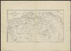
Kaart der provincie Noordbrabant
1 : 200000 J. Kuypers op steen gebragt, gedrukt ... door M. van Osch. 's Hertogenbosch : Van Osch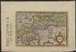
Zeelandia
1 : 780000 [engraver: Jodocus Hondius I] [S.l.] : [s.n.]
Brabantiae pars Orientalis
1 : 160000 Mollova mapová sbírka Wit, Frederik de Covens, Johannes I
Qvarta Pars Brabantiae cujus caput Sylvadvcis
1 : 180000 Mollova mapová sbírka Burght, Willebrord van der Bleau, Willem Janszon
Tetrarchiae Antverpiensis pars meridionalis una cum Mechliniensi dominio in ejusdem ditiones subjacentes accuratissime divisa
1 : 130000 Meklenbursko (Německo) Visscher, Nicolaes Jansz. Schenk, Pieter apud Petr Schenk junior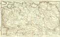
Partie Septentrionale du Duché de Brabant
1 : 146000 Mollova mapová sbírka Jaillot, Alexis-Hubert
Brabantiae Batavae pars occidentalis, sive Antverpiensis tetrarchiae pars septentrionalis, comprehendens Baroniam Bredanam, Marchionatum Bergensem ad Zomam, aliasque minores ditiones
1 : 125000 per Nicolaum Visscher. [Amsterdam] : nunc apud Petrum Schenk Junior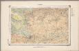
22. Kempen, uit: Geologische kaart van Nederland / door W.C.H. Staring ; bew. aan de Topographische Inrichting
1 : 200000 Winand Carel Hugo Staring 1808-1877; Topographische Inrichting, 's-Gravenhage 's-Gravenhage : Belinfante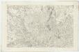
III ; 1.K., uit: Carte chorographique des Pays-Bas Autrichiens / ... par le Comte de Ferraris ; gravée par L.A. Dupuis
1 : 86400 Annotatie: Bladen linksboven genummerd met Romeinse cijfers, rechtsboven met een cijfer en een letter; Met opdracht aan keizer Joseph II (bl.XVI); Met plattegrond van Brussel (bl. XXI), overzichtskaart (bl. XXII) en bladwijzer (bl. XXIII); Annotatie geografische gegevens: Schaalstokken: Echelle de Toises ou de Lieues communes de France; Echelle de Verges ou de Lieues de Brabant; Echelle de Milles d'Allemagne (bl. XVII); Echelle de Mètres; In de hoeken lengte- en breedtematen T.M.e en T.P.e Joseph-Jean François Ferraris Comte de 1726-1814; L.A. Dupuis [S.l. : s.n.]
22. Kempen, uit: Geologische kaart van Nederland : schaal van 1:200.000 / door W.C.H. Staring ; uitgevoerd door het Topographisch Bureau van Oorlog ; uitgegeven op last van Zijne Majesteit Den Koning
Annotatie: Impressum ontleend aan omslag; Kaart "Nederland de dijken weggedacht" [kaart 25] en kaart 13 (bladwijzer) vermelden het jaar 1869; Kaart 'Limburg en de Hesbaije' (bladnr. 26) vermeldt het jaar 1868; Blad 5/9 ontbreekt Topographische Inrichting, 's-Gravenhage; Topographisch Bureau Haarlem : A.C. Kruseman