Maps of Netherlands

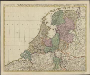
Belgica foederata complectens septem provincias, ducatum Geldriae, comitatus Hollandiae et Zelandiae, dioeceses Trajectum, Transisulaniam, Groningam et Frisiam et circumjacentes provincias.
1 : 650000 Amsterdam : venalis habent Ger. et Leon Valk
Provinces-Unies des Pays-Bas : avec leurs acquisitions dans la Flandre, le Brabant, le Limbourg et le Lyege
1 : 700000 par le Sr. Sanson, Géographe ordinaire du Roy Cordier, sculp. Paris : H. Jaillot
Provinces-Unies des Pays-Bas avec leurs Acquisitions dans la Flandre, le Brabant, le Limbourg et le Lyege
1 : 770000 Mollova mapová sbírka Sanson, Guillaume Cordier, Louis Jaillot, Alexis Hubert
Provinces-Unies des Pays-Bas
1 : 625000 Mollova mapová sbírka Sanson, Guillaume Jaillot, Alexis Hubert
Provinces unies des Pays-Bas avec leurs acquisitions dans la Flandre, le Brabant, le Limbourg, et le Lyege et les places qu'elles tiennent sur le Rhin dans le Duché de Cleves, et dans l'Archevesché et Eslectorat de Cologne
1 : 700000 par G. Valck. À Amsterdam : chez G. Valck
Niederland u. Belgien.
1 : 1000000 Ziegler, J. M.
Les Dix-Sept Provinces Des Pays-Bas
1 : 760000 Mollova mapová sbírka Sanson, Guillaume Sanson, Guillaume
Oud Nederland zo als het zelve door de Batavieren, Marezaaten, Sturien, Frisiabonen ... en andere volkeren oudtijds bewoond wierd, naar de plaatsing der beste schrijveren.
1 : 3500000 Te Amsterdam : bij Arend Fokke Simonsz.
La republica Battava
1 : 2400000 Nizozemsko Zatta, Antonio Zatta
Provincie unite de Paesi Bassi
1 : 870000 descritte da Nicolo Sansone d'Abbeville ... e novamente intagliate da Gio. Batt.a Falda. Roma : Gio. Giacomo Rossi
Théatre de la guerre actuelle, en Allemagne, en Pologne et en Turquie. n2
1 : 900000 Chanlaire, Pierre Grégoire 1758-1817 Paris : chez l'auteur P. G. Chanlaire
Descriptio veteris agri Batavi et Frisii omnisque regionis quae hodie est in dicione VII. Foederatorum cis et ultra Rhenum
1 : 950000 auctore Mensone Alting. [Amstelaedami] : [apud Henricum Wetstenium]
Provinces Vnies de Pays Bas
1 : 861000 Nizozemsko
Provincie Vnite De Paesi Bassi
1 : 780000 Mollova mapová sbírka Sanson, Nicolas De Rossi, Giovanni Giacomo
Carte de la république de France, 8
1 Blatt : 35 x 59 cm s.n.
A new and correct map of the seven provinces : drawn from the most approved maps and charts : the whole being regulated by astronomical observations
1 : 920000 by Eman Bowen. [London] : Tyndal
The Seven United Provinces of Holland, Groningen, Gelders, Friesland, Overyssel, Utrecht, and Zealand.
1 : 1180000 Melish, John
5me [Driehoeksnet], uit: Nouvelle carte de la Hollande, d'après Kraijenhoff et les meilleures cartes connues / Établissement Géographique de Bruxelles, fondé par Ph. Vander Maelen
1 : 117000 Annotatie: De bladen zijn genummerd 1-24. De bladen 2 t/m 24 hebben elk een afzonderlijke titel. Blad 5 bevat: Triangulations et positions. Blad 9 bevat: Plan d'Amsterdam; De kaartbladen 1, 5, 9 en 24 zijn niet ingekleurd; Van kaartblad 24 is een extra (ingekleurd) exempl. aanwezig; Annotatie geografische gegevens: 2 schaalstokken: 5 Echelle de 5 lieues de 20 au degré ... (= 23,2 cm) en 7380 Echelle de 5 lieues de 20 au degré ... (= 23,2 cm); Legenda; Met indexkaart: Carte d'assemblage Philippe Marie Guillaume Vander Maelen 1795-1869; Établissement Géographique de Bruxelles Bruxelles : Établissement Géographique
Pays Bas septentrionale.
1 : 1130000 Janvier, Jean
Carte des sept provinces unies des Pays-Bas connues sous le nom général de Hollande
1 : 700000 dressée par Hérisson ... A Paris : chez Basset
Artificiosa et geographica tabula sub leonis figura XVII. inferiori Germaniae provincias representans, cui addita sunt singularum insignia, una cum ordinaria praefecturarum distinctione, longe elimatius quam hactenus unquam expressa
1 : 1480000 Belgie Visscher, Claes Jansz. C.I. Visscher
Holland or the United Provinces.
from A new systeme of the mathematicks: containing I. Arithmetick, as well natural and decimal, as in species, or the principles of algebra. II. Practical geometry, together with the first six books of Euclid's Elements, as also the eleventh and twelfth, symbo
Belgii pars septentrionalis communi nomine vulgo Hollandia ... = Land caerte van ’t Verenigde Nederland met ’t gene daer onderhoort, verdeelt in syn provincien en minder verdelingen
1 : 800000 naaukeurig aangewesen en uyt de beste aantekeninge opgestelt. Ultrajecti : Cornelius Kribber
A new and exact map of the United Provinces, or Netherlands &c.
from The world described, or, A new and correct sett of maps : shewing the kingdoms and states in all the known parts of the earth, with the principal cities, and most considerable towns in the world ... / ... by Herman Moll, geographer ...
Holland, Friesland, Groningen, Overyssel, Gelders, Utrecht and Zealand.
1 : 2471040 Carey, Mathew
The Seven United Provinces of Holland, Groningen, Gelders, Friesland, Overyssel, Utrecht and Zealand.
1 : 2407680 Carey, Mathew
The Seven United Provinces of Holland, Groningen, Gelders, Friesland, Overyssel, Utrecht and Zealand.
1 : 2407680 Carey, Mathew