Maps of Rotterdam

Hollandiae Meridionalis pars I : continens novissimam Delflandiae, Schielandiae et circumjacentium insularum descriptionem
1 : 140000 IVDA [= Johan van den Aveele] Amstelaedami : ex typographia Gerardi Valk et Petri Schenk
Delflandia, Schielandia, et insulae trans Mosam illis objacentes ut sunt Voorna, Overflackea, Goerea, Yselmonda, etc
1 : 130000 exc. Guilj. Blaeuw. [Amsterdam] : Guilj. Blaeuw
DELFLANDIA, | SCHIELANDIA, | et Insulæ trans Mosam | illis objacentes ut sunt | VOORNA, OVERFLACKEA, | GOEREA, YSELMONDA, etc.
Exc. Guilj. Blaeuw.
Delflandia, Schielandia, et Insulae trans Mosam illis obiacentes ut sunt Voorna, Overflackea, Goerea, Yselmonda, etc. [Karte], in: Novus Atlas, das ist, Weltbeschreibung, Bd. 1, S. 399.
1 Karte aus Atlas Blaeu, Joan Blaeu, Willem Janszoon
[100][103] Novissima Delflandiae, Schielandiae ..., uit: Atlas sive Descriptio terrarum orbis
Annotatie: Gedigitaliseerde versie. Amsterdam. Heiloo : Picturae (vervaardiger), 2015. tiff-bestand. Gedigitaliseerd: 07-01-2015; Origineel: Universiteitsbibliotheek Vrije Universiteit (XL.05127.-) ; Netherlands; Titelpagina ontbreekt Wit, Frederik de Amsterdam : Frederick de Wit
Delflandia, Schielandia, et Insulae trans Mosam illis obiacentes ut sunt Voorna, Overflackea, Goerea, Yselmonda, etc. [Karte], in: Theatrum orbis terrarum, sive, Atlas novus, Bd. 1, S. 434.
1 Karte aus Atlas Blaeu, Joan Blaeu, Willem Janszoon
Delflandia, Schielandia, et Insulae trans Mosam illis obiacentes ut sunt Voorna, Overflackea, Goerea, Yselmonda, etc. [Karte], in: Le théâtre du monde, ou, Nouvel atlas contenant les chartes et descriptions de tous les païs de la terre, Bd. 1, S. 430.
1 Karte aus Atlas Blaeu, Willem Janszoon und Blaeu, Joan Blaeu, Willem Janszoon
[Recto], uit: Delflandia, Schielandia, et insulae trans Mosam illis objacentes ut sunt Voorna, Overflackea, Goerea, Yselmonda, etc. / [Willem Jansz. Blaeu]
1 : 130000 Annotatie: Oorspr. verschenen in: Appendix Theatri A. Ortelii et Atlantis G. Mercatoris ... - Amsterdami : apud Guiljelmum Blaeu, 1631; Bestaat uit twee aan elkaar gemonteerde kaartdelen, afkomstig van twee afzonderlijke afdrukken van de kaart. Bij de rechterhelft ontbreekt op de achterzijde de tekst; Annotatie geografische gegevens: Noordwest boven Blaeu, Willem Jansz. [Amsterdam : exc. Guilj. Blaeuw]
Novissima Deflandiae, Schielandiae et circumiacentium insularum ut Voornae, Overflackeae, Goereae, Iselmondae, aliamrumque tabula [Karte], in: Gerardi Mercatoris et I. Hondii Newer Atlas, oder, Grosses Weltbuch, Bd. 1, S. 445.
1 Karte aus Atlas Mercator, Gerhard und Hondius, Jodocus Jansson, Jan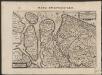
Novissima Delflandiæ, Schielandiæ et circumiacentium insularum ut Voornæ, Overflackeæ, Goeree, Iselmondæ, aliarumque tabula
1 : 360000 [Balthasar Florisz. van Berckenrode] Amstelodami : sumptibus Henrici Hondii
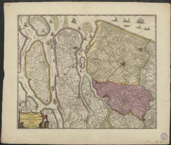
Delflandia, Schielandia et circumjacentes insulae ut Voorna, Overflackea, Goerea, Yselmonda et aliae / ex conatibus geographicis Nicolai Visscher
1 : 115000 Annotatie: Cum privilegio ordinum Hollandiae et West-Frisiae; Linksonder opdracht aan Jacobus van Dussen; Oorspr. verschenen te Amst. Bat. (Amsterdam) bij Nicolaes Visscher, na 1677; Annotatie geografische gegevens: Twee schaalstokken: Een Hollandtsche myle van 2000 Rhynlandtsche roeden (=6,1 cm); Een France myle ofte een ure gaens (=4,7 cm); West boven Petrus Schenk 1693-1775 [Amsterdam : Nunc apud Petrum Schenk Junior]

Novissima Delflandiae, Schielandiae et circumiacentium insularum ut Voornae, Overflackeae, Goereae, Iselmondae, aliarumque tabula [Karte], in: Novus atlas absolutissimus, Bd. 3, S. 168.
1 Karte aus Atlas Janssonius Offizin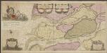
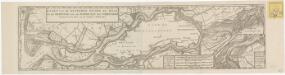
Paskaerte van het inkoomen van de Maes tot aen 't eylandt Roosenburgh als mede 't inkoomen van 't Goereesche gat tot aen Oude Hoornsluys [...], seer naeukeurich opgestelt
1 : 65000 't Amsterdam : bij Johannes van Keulen aen de Nieuwbrugh inde Gekroonde Lootsman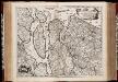
Delflandia, Schielandia et circumjacentes insulae ut Voorna, Overflackea, Goerea, Yselmonda et aliae / ex conatibus geographicis Nicolai Visscher
1 : 180000 Annotatie: Cum privilegio Ordinum Hollandiae et West-Frisiae; Met opdracht door Nicolaus Vischer aan Jacobus a Dussen; Origineel is Blad 52 in atlas factice; Annotatie geografische gegevens: Met 2 schaalstokken; West boven Nicolaes Jansz Visscher sr 1618-1679 Amst. Bat. [=Amsterdam] : Nicolaes Visscher

Delflandia, Schielandia et circumjacentes Insulae ut Voorna, Overflackea, Goerea, Yselmonda et aliae, ex conatibus Geographicis
1 : 123000 Mollova mapová sbírka Visscher, Nicolaes Jansz. Schenk, Peter II
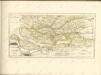
Carte de la Hollande ou sont les envs. de Rotterdam, d'Hellevoetsluys, de Goerée, de Villemstat &c.
1 : 300000 gravé par Delahaye Lainé. [Paris] : par le sr. Robert géographe ordin. du roi
Delflandia, Schielandia, et insulae trans Mosam illis objacentes ut sunt Voorna, Over Flackea, Goerea, Ysel Monda, etc
1 : 120000 Nizozemsko Blaeu, Willem Janszoon Guijl. Blaeuw
Nieuwe kaart van het Zuid Westelykste deel van Holland, behelzende de baljuwschappen Voorne, Putten enz.
1 : 150000 te Amsterdam : by Isaak Tirion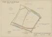
Polder Nieuw- en Oud-Guldeland, gemeente Geervliet.

Land-kaart van Holland, een gedeelte van Batavie soo als het was 1612.
1 : 500000 [S.l.] : [s.n.]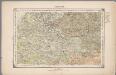
18. Biesbosch, uit: Geologische kaart van Nederland / door W.C.H. Staring ; bew. aan de Topographische Inrichting
1 : 200000 Winand Carel Hugo Staring 1808-1877; Topographische Inrichting, 's-Gravenhage 's-Gravenhage : Belinfante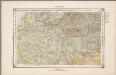
18. Biesbosch, uit: Geologische kaart van Nederland / door W.C.H. Staring ; bew. aan de Topographische Inrichting
1 : 200000 Winand Carel Hugo Staring 1808-1877; Topographische Inrichting, 's-Gravenhage 's-Gravenhage : Belinfante
17me Brielle, uit: [Nouvelle carte de la Hollande, d'après Kraijenhoff et les meilleures cartes connus] / [Ph. Vandermaelen]
1 : 130000 Annotatie: Ontbreekt: bl. 1-12 Vandermaelen, Philippe Marie Guillaume Bruxelles : Établissement Géographique
17me Brielle, uit: Nouvelle carte de la Hollande, d'après Kraijenhoff et les meilleures cartes connues / Établissement Géographique de Bruxelles, fondé par Ph. Vander Maelen
1 : 117000 Annotatie: De bladen zijn genummerd 1-24. De bladen 2 t/m 24 hebben elk een afzonderlijke titel. Blad 5 bevat: Triangulations et positions. Blad 9 bevat: Plan d'Amsterdam; De kaartbladen 1, 5, 9 en 24 zijn niet ingekleurd; Van kaartblad 24 is een extra (ingekleurd) exempl. aanwezig; Annotatie geografische gegevens: 2 schaalstokken: 5 Echelle de 5 lieues de 20 au degré ... (= 23,2 cm) en 7380 Echelle de 5 lieues de 20 au degré ... (= 23,2 cm); Legenda; Met indexkaart: Carte d'assemblage Philippe Marie Guillaume Vander Maelen 1795-1869; Établissement Géographique de Bruxelles Bruxelles : Établissement Géographique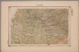
18. Biesbosch, uit: Geologische kaart van Nederland : schaal van 1:200.000 / door W.C.H. Staring ; uitgevoerd door het Topographisch Bureau van Oorlog ; uitgegeven op last van Zijne Majesteit Den Koning
Annotatie: Impressum ontleend aan omslag; Kaart "Nederland de dijken weggedacht" [kaart 25] en kaart 13 (bladwijzer) vermelden het jaar 1869; Kaart 'Limburg en de Hesbaije' (bladnr. 26) vermeldt het jaar 1868; Blad 5/9 ontbreekt Topographische Inrichting, 's-Gravenhage; Topographisch Bureau Haarlem : A.C. Kruseman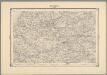
13, uit: Topografische atlas van het Koninkrijk der Nederlanden
Annotatie: Map met 19 losse krt. schaal 1:200.000 en 1 bladwijzer schaal 1:1.000.000 ['s-Gravenhage : Ministerie van Oorlog, Topografisch Bureau]