Maps of Eemsmond

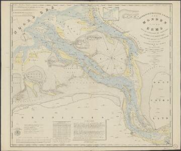
Hydrographische kaart der monden van de Eems met de Uithuizer en Groninger Wadden tot Hornhuizen
1 : 50000 trigonometrisch opgenomen en in plan gebragt op last van het Departement van Marine door S.J. Keuchenius, 1833 gegrav. door J.C. Zurcher ; herz. door A. van Rhijn, 1850 ; corr. d. v. Baarsel & Tuyn, 1853. ['s-Gravenhage] : Departement van Marine
3 Uithuizen, uit: Topographische en militaire kaart van het Koningrijk der Nederlanden / vervaardigd door de officieren van den Generale Staf ; en gegraveerd op het Topographisch Bureau, van het Ministerie van Oorlog
1 : 50000 titelvariant: TMK; Annotatie: Met bladwijzer op schaal 1:600.000. - 1915; Met Verklaring van de topographische en militaire kaart van het Koninkrijk der Nederlanden. - 1910; Bd. 1: titelblad, bladwijzer, verklaring, bladen 1 t/m 32; Bd. 2: bladen 33 t/m 62 Generale Staf, Nederland; Ministerie van Oorlog. Topographisch Bureau ['s-Gravenhage : Ministerie van Oorlog]
139. Borkum. (Germany)
1 : 100000 Reichsamt fur Landesaufnahme
Composite: 139. Borkum. (Germany)
1 : 100000 Reichsamt fur Landesaufnahme
Meßtischblatt Juist (West)
1 : 250000 Juist (West). - Aufn. 1891, hrsg. 1892. - 1:25000. - [Berlin]: Reichsamt für Landesaufnahme, 1892. - 1 Kt.
Meßtischblatt 914/1010, 1011 : Borkum, 1936
1 : 250000 Borkum. - Hrsg. 1935. - 1:25000. - [Berlin]: Reichsamt für Landesaufnahme, 1936. - 1 Kt.
Meßtischblatt 914/1010, 1011 : Insel Borkum, 1892
1 : 250000 Insel Borkum. - Aufn. 1891. - 1:25000. - [Berlin]: Reichsamt für Landesaufnahme, 1892. - 1 Kt.
DELFSIIL.
[Amsterdam : Joan Blaeu]
Plan van Delfzyl
1 : 2000
't Fort van GRIET-ZYL in Oost-Vrieslant : [fortification plan].
[Amsterdam : Joan Blaeu]
Meßtischblatt 2408 : Westermarsch, 1942
1 : 250000 Westermarsch. - Bericht. 1939, Ausg. 1942. - 1:25000. - [Berlin]: Reichsamt für Landesaufnahme, 1942. - 1 Kt.
Meßtischblatt Juist (Ost)
1 : 250000 Juist (Ost). - Aufn. 1891, hrsg. 1892. - 1:25000. - [Berlin]: Reichsamt für Landesaufnahme, 1892. - 1 Kt.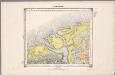
4. Hunsingoo, uit: Geologische kaart van Nederland / door W.C.H. Staring ; bew. aan de Topographische Inrichting
1 : 200000 Winand Carel Hugo Staring 1808-1877; Topographische Inrichting, 's-Gravenhage 's-Gravenhage : Belinfante
Groninga dominium
1 : 175000 auctore Bartholdo Wicheringe sculpserunt Everardus Sim. Hamers-veldt et Sal. Rogeri. Amstelodami : excudebat Joannes Janssonius
GRONINGA | DOMINIVM
Auctore | Bartholdo Wicheringe [Amsterdam : Joan Blaeu]
GRONINGA | DOMINIVM
Auctore | Bartholdo Wicheringe [Amsterdam : Joan Blaeu]
[Recto], uit: Groninga dominium / auctore Bartholdo Wicheringe ; sculpserunt Everardus Sim. Hamers-veldt, et Sal. Rogeri
1 : 175000 Annotatie: Uit: Gerardi Mercatoris et I. Hondii Atlas ofte Afbeeldinghe vande gantsche Weerldt ... - Amsterdam : Ian Ianssen, 1634 Wicheringe, Bartholdus; Hamersveldt, Everard Symonsz. van; Rogiers, Salomon Amstelodami : excudebat Ioannes Ianssonius
Geographische beschrivinge vande Pr: Stadt Gr. en Oml. : vervattende in sich alle heerlyckheden, fortressen, dorpen, adelycke ende considerabele huysen : met de wapens van de voornaemste ende gequalificeerste adeldom der opgemelte provincie
1 : 90000 naet leven afgeteeckent door de gebroederen W. en F. Conders van Helpen Cornelius Appeus sculpsit. [S.l.] : [s.n.]

Tabula Frisiae, Groninghae et Territory, Embdensis
1 : 460000 Mollova mapová sbírka Visscher, Nicolaes Goos, Abraham Visscher, Nicolaus I.
Groninga Dominium. [Karte], in: Novus Atlas, das ist, Weltbeschreibung, Bd. 1, S. 414.
1 Karte aus Atlas Blaeu, Joan Blaeu, Willem Janszoon
Groninga Dominium. [Karte], in: Theatrum orbis terrarum, sive, Atlas novus, Bd. 1, S. 450.
1 Karte aus Atlas Blaeu, Joan Blaeu, Willem Janszoon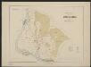
Groninga Dominium. [Karte], in: Gerardi Mercatoris et I. Hondii Newer Atlas, oder, Grosses Weltbuch, Bd. 1, S. 475.
1 Karte aus Atlas Mercator, Gerhard und Hondius, Jodocus Jansson, Jan
Groninga Dominium. [Karte], in: Le théâtre du monde, ou, Nouvel atlas contenant les chartes et descriptions de tous les païs de la terre, Bd. 1, S. 447.
1 Karte aus Atlas Blaeu, Willem Janszoon und Blaeu, Joan Blaeu, Willem Janszoon
Groninga Dominium. [Karte], in: Novus atlas absolutissimus, Bd. 3, S. 226.
1 Karte aus Atlas Janssonius Offizin
2, uit: Topografische atlas van het Koninkrijk der Nederlanden
Annotatie: Map met 19 losse krt. schaal 1:200.000 en 1 bladwijzer schaal 1:1.000.000 ['s-Gravenhage : Ministerie van Oorlog, Topografisch Bureau]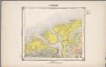
4. Hunsingoo, uit: Geologische kaart van Nederland / door W.C.H. Staring ; bew. aan de Topographische Inrichting
1 : 200000 Winand Carel Hugo Staring 1808-1877; Topographische Inrichting, 's-Gravenhage 's-Gravenhage : Belinfante
4. Hunsingoo, uit: Geologische kaart van Nederland : schaal van 1:200.000 / door W.C.H. Staring ; uitgevoerd door het Topographisch Bureau van Oorlog ; uitgegeven op last van Zijne Majesteit Den Koning
Annotatie: Impressum ontleend aan omslag; Kaart "Nederland de dijken weggedacht" [kaart 25] en kaart 13 (bladwijzer) vermelden het jaar 1869; Kaart 'Limburg en de Hesbaije' (bladnr. 26) vermeldt het jaar 1868; Blad 5/9 ontbreekt Topographische Inrichting, 's-Gravenhage; Topographisch Bureau Haarlem : A.C. Kruseman
Dominii Groningae nec non maximae partis Drentiae Novissima Delineatio
1 : 180000 Mollova mapová sbírka Visscher, Nicolaes Hooghe, Romeyn de Visscher, Nicolaus