Maps of South Holland

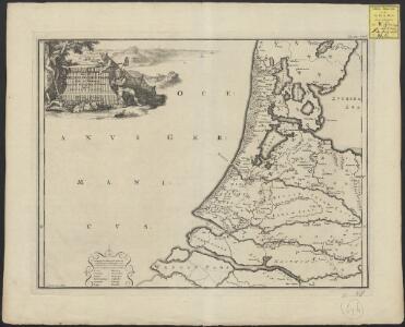
Pars II Fresiae haereditariae a Mosa in Kinnemum, quae hodie Hollandia, sub Henricis et Suevis
1 : 480000 auctore Menso Alting G. de Broen fecit. [Amstelaedami] : [apud Henricum Wetstenium]
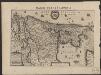
Descriptio Frisiae haereditariae inter Scaldim et Kinnemum sub Carolinis
1 : 600000 auctore Mensone Alting G. de Broen fecit. [Amstelaedami] : [apud Henricum Wetstenium]
Belgio confederato altrimenti detto l'Olanda, delineato
1 : 1200000 delineato, e descritto dal P. Coronelli. [Napoli] : [Vincenzo Coronelli]
Holland
1 : 800000 [Franz Johann Joseph von Reilly] [Wien] : [Franz Johann Joseph von Reilly]
Comitatus Hollandiae tabula pluribus locis
1 : 308000 Nizozemsko Visscher, Nicolaes Jansz. Schenk, Pieter apud Petrum Schenk Junior
Comitatus Hollandiae tabula pluribus locis
1 : 308000 Nizozemsko Wit, Frederick de by Frederick de Wit
Comitatus Hollandiæ novissima descriptio
1 : 360000 designatore Balthazaro Florentio a Berckenrode Salomon Rogiers sculpsit. Amstelodami : sumptibus Henrici Hondii ...
Comitatus Hollandiae novissima descriptio [...] [Karte] d' Eÿlanden Texel, Vlielandt en der Schelling. [Nebenkarte], in: Gerardi Mercatoris et I. Hondii Newer Atlas, oder, Grosses Weltbuch, Bd. 1, S. 442.
1 Karte aus Atlas Mercator, Gerhard und Hondius, Jodocus Jansson, Jan
Charte von Holland
1 : 300000 nach astronomischen Beobachtungen, den Messungen des Schnellius &.c.c. und den vorzüglichsten Specialcharten neu entworfen von F.L. Güssefeld. Nürnberg : bey den Hom[ännischen Erben]
Comitatus Hollandiæ novissima descriptio
1 : 360000 designatore Balthazaro Florentio a Berckenrode Salomon Rogiers sculpsit. Amstelodami : sumptibus Joannis Janssonii
Hollandia Comitatus
1 : 520000 [Caspar Merian] [Frankfurt am Main] : Caspar Merian]
Hollandia Comitatus
1 : 360000 [Cornelis Danckerts jr.] Amstelodami : apud Cornelio Dankero
HOLLANDIA | COMITATVS
Apud Guiljelmum Blaeu
La Hollande suivant les nouvelles observations de messrs. de l'Academie Royale des Sciences, etc. augmentées de nouveau
1 : 900000 [Pieter van der Aa] A Leide : chez Pierre van der Aa
HOLLANDIA | COMITATVS
Apud Guiljelmum Blaeu
Le Comté de Hollande
1 : 240000 dressé sur les memoires les plus nouveaux par le Sr. Sanson, geographe ordinaire du roy presenté à ... le Dauphin ... par ... Alexis Hubert Jaillot. A Amsterdam : chez I. Cóvens et C. Mortier
Comitatus Hollandiæ tabula pluribus locis recens
1 : 300000 pluribus locis recens emendata a Nicolao Visscher. [Amsterdam] : nunc apud Petrum Schenk junior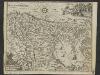
Condado de Olanda
1 : 1000000 [Jacques Harrewijn] [Madrid] : [Francisco Laso]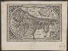
Comitatus Hollandia
1 : 1200000 [Abraham Goos engraver] [Amsterdam etc.] : [Abraham Goos etc.]
Le Comte de Hollande
1 : 750000 auctore Baltha: Florentius de Berkenrode. [Amsterdam] : [Jacob Aertsz. Colom]
Charte von Holland
1 Karte : Kupferdruck ; 55 x 43 cm Güssefeld by den Hom. Erben
Comitatus Hollandiæ tabula pluribus locis recens
1 : 300000 pluribus locis recens emendata a Francisco Caroli J. Bormeester. eccu. Amstel' : Petrum Schenk exc.
Comitatus Hollandiæ tabula pluribus locis recens
1 : 300000 pluribus locis recens emendata a Frederico de Wit. Gedruckt 't Amsterdam : by Frederick de Wit ...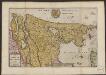
Le Comte de Hollande
1 : 750000 auctore Baltha: Florentius de Berkenrode. [Amsterdam] : La Feuille exc.
Comitatus Hollandiæ tabula pluribus locis recens
1 : 320000 pluribus locis recens emendata a Justo Danckerts. [Amsterdam] : Justus Danckerts
Comitatus Hollandiae tabula
1 : 300000 pluribus locis recens emendata a Frederico de Wit. [Amsterdam] : ex officina I. C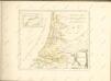
Comitatus Hollandiae novissima descriptio
1 : 760000 designatore Balth. Flor. a Berckenr. Amstelodami : sumptibus Henrici Hondii.
Holland
1 : 440000 [François Halma] [Leeuwarden] : [Henrik Halma]