Maps of Bielsko County

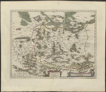
DVCATVS | OSWIECZENSIS, | et | ZATORIENSIS.
[Amsterdam : Joan Blaeu]
Ducatus Oswieczensis, Et Zatoriensis, Descriptio. [Karte], in: Theatrum orbis terrarum, S. 375.
1 Karte aus Atlas Ortelius, Abraham Vrients, Jan Baptista
Ducatus Oswieczensis, Et Zatoriensis, Descriptio. [Karte], in: Theatrum orbis terrarum, S. 280.
1 Karte aus Atlas Ortelius, Abraham
Auschwitz u. Sator
1 : 2000000 Herzogtum Auschwitz
Wadowice.
from Spezialkarte der osterreichisch-ungarischen Monarchie.
Bielitz und Biala.
from Spezialkarte der osterreichisch-ungarischen Monarchie.
Podrobná mapa Markrabství moravského a Vévodství slezkého
1 : 100000 Biała (Polsko : oblast) Srp, Jan Jos. R. Vilímek
Wadowice
1 : 75000 Wadowice (Polsko) Cokorac K. u. k. Militärgeographisches Institut
Bielitz und Biała
1 : 75000 Bielsko-Biała-oblast (Polsko) Bloschitz, R. K. u. k. Militärgeographisches Institut
Bielitz und Biała
1 : 75000 Bielsko-Biała (Polsko : oblast) Otawa K. u. k. militär-geographisches Institut
Bielitz und Biała
1 : 75000 Bielsko-Biała (Polsko : oblast) Otawa K. u. k. Militärgeographisches Institut


Myslowitz und Oswiecim.
from Spezialkarte der osterreichisch-ungarischen Monarchie.
Chrzanow und Krzeszowice.
from Spezialkarte der osterreichisch-ungarischen Monarchie.
Myslowitz und Oświecim
1 : 75000 Bloschitz, R. K. u. k. militär-geographisches Institut
Polhora
1 : 75000 Oravská Polhora-oblast (Slovensko) Vojenský zeměpisný ústav
Polhora a Maków
1 : 75000 Oravská Polhora (Slovensko : oblast) Vojenský zeměpisný ústav
Polhora a Maków
1 : 75000 Oravská Polhora (Slovensko : oblast) Vojenský zeměpisný ústav
Chrzanów und Krzeszowice
1 : 75000 Chrzanów (Polsko) Heimbach K. u. k. Militärgeographisches Institut
III. vojenské mapování 4162
1 : 75000
Saybusch
1 : 75000 Saybusch Schrift und Gerippe v. W. Ahl. Terrainschraffirung v. Oberlt. Hettwer
Maków und Podvilk
1 : 75000 Maków Podhalański, Podwilk Geripp: Offiz. Spitzer u. Assist. Irblich. Terrain: Vorst. Adler u. Oblt. Fenz
III. vojenské mapování 4163
1 : 75000
Hrčava
1 : 75000 Hrčava (Česko) Vojenský zeměpisný ústav
Żywiec
1 : 75000 Polsko Vojenský zeměpisný ústav
Żywiec
1 : 75000 Polsko Čs. voj. zeměpisný ústav
Żywiec
1 : 75000 Polsko Kartografické odd. při Min. nár. obrany
Maków und Podvilk
1 : 75000 Oravská Polhora-oblast (Slovensko) Adler K. u. k. Militärgeographisches Institut