Maps of Aabenraa Municipality

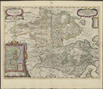
PRÆFECTVRA | APENRADE | et Luntoft herde.
Christian Rothgiesser | Husum. sculpsit. [Amsterdam : Joan Blaeu]
Praefectvra Apenrade et Luntoft herde
1 : 95000 Mollova mapová sbírka Mejer, Johannes Rothgiesser, Christian Lorenzen Blaeu, Joan I.
13. Apenrade. (Germany)
1 : 100000 Reichsamt fur Landesaufnahme
Messtischblatt 99 : Gravenstein, 1879 Gravenstein
1 : 250000 Gravenstein. - Aufn. 1877. - 1:25000. - [Berlin]: Reichsamt für Landesaufnahme, 1879. - 1 Kt.
Messtischblatt 98 : Klippleff,1879 Klipleff
1 : 250000 Klipleff. - Aufn. 1877. - 1:25000. - [Berlin]: Reichsamt für Landesaufnahme, 1879. - 1 Kt.
Messtischblatt 97 : Tingleff, 1914 Tingleff
1 : 250000 Tingleff. - Aufn. 1878, hrsg. 1880, Auflagedr. 1914.. - 1:25000. - [Berlin]: Reichsamt für Landesaufnahme, 1914. - 1 Kt.
Meßtischblatt 77 : Warnitz, 1879
1 : 250000 Warnitz. - Aufn. 1877. - 1:25000. - [Berlin]: Reichsamt für Landesaufnahme, 1879. - 1 Kt.
Meßtischblatt 76 : Apenrade, 1879
1 : 250000 Apenrade. - Aufn. 1877. - 1:25000. - [Berlin]: Reichsamt für Landesaufnahme, 1879. - 1 Kt.
Meßtischblatt 75 : Jordkirch, 1880
1 : 250000 Jordkirch. - Aufn. 1878. - 1:25000. - [Berlin]: Reichsamt für Landesaufnahme, 1880. - 1 Kt.
Messtischblatt 96 : Bülderup, 1880 Bülderup
1 : 250000 Bülderup. - Aufn. 1878. - 1:25000. - [Berlin]: Reichsamt für Landesaufnahme, 1880. - 1 Kt.
Meßtischblatt 74 : Bedstedt, 1880
1 : 250000 Bedstedt. - Aufn. 1878. - 1:25000. - [Berlin]: Reichsamt für Landesaufnahme, 1880. - 1 Kt.
Meßtischblatt 55 : Rauberg, 1880
1 : 250000 Rauberg. - Aufn. 1878. - 1:25000. - [Berlin]: Reichsamt für Landesaufnahme, 1880. - 1 Kt.
Meßtischblatt 56 : Hoptrup, 1879
1 : 250000 Hoptrup. - Aufn. 1877. - 1:25000. - [Berlin]: Reichsamt für Landesaufnahme, 1879. - 1 Kt.
Meßtischblatt 57 : Süder Wilstrup, 1879
1 : 250000 Süder Wilstrup. - Aufn. 1877. - 1:25000. - [Berlin]: Reichsamt für Landesaufnahme, 1879. - 1 Kt.
Meßtischblatt 54 : Toftlund, 1880
1 : 250000 Toftlund. - Aufn. 1878. - 1:25000. - [Berlin]: Reichsamt für Landesaufnahme, 1880. - 1 Kt.
Composite: 12. Lugumkloster. (Germany)
1 : 100000 Reichsamt fur Landesaufnahme
Messtischblatt 130 : Glücksburg, 1926 Glücksburg
1 : 250000 Glücksburg. - Aufn. 1877, hrsg. 1879, berichtigt 1926. - 1:25000. - [Berlin]: Reichsamt für Landesaufnahme, 1926. - 1 Kt.
Messtischblatt 129 : Bau, 1900 Bau
1 : 250000 Bau. - Aufn. 1877, hrsg. 1879, einz. Nachtr. 1900. - 1:25000. - [Berlin]: Reichsamt für Landesaufnahme, 1900. - 1 Kt.
Messtischblatt 128 : Weibek, 1895 Weibek
1 : 250000 Weibek. - Aufn. 1878, hrsg. 1880, einz. Nachtr. 1895. - 1:25000. - [Berlin]: Reichsamt für Landesaufnahme, 1895. - 1 Kt.
Messtischblatt 127 : Ladelund, 1880 Ladelund
1 : 250000 Ladelund. - Aufn. 1878. - 1:25000. - [Berlin]: Reichsamt für Landesaufnahme, 1880. - 1 Kt.
Nieuwe afteekening van het eijlandt Alsen en de vaste kust daar agter geleegen : vertoonende de rivieren van Apenrader en Flensborgh, is geleegen aen de west kust in de Belt Zee
Denmark Gerard van Keulen
DVCATVS | SONDERBORG | cum adjacentibus Territoriis | ALSSEN, SVNDEWITT, | et Luxburgh.
Matthis Peterss G.s. v. | Claus P. Goldtschmide unt gbr. | Huss. Cimbr. sculp. [Amsterdam : Joan Blaeu]
Composite: 13. Apenrade. (Germany)
1 : 100000 Reichsamt fur Landesaufnahme
23. Flensburg. (Germany)
1 : 100000 Reichsamt fur Landesaufnahme
12. Lugumkloster. (Germany)
1 : 100000 Reichsamt fur Landesaufnahme
Composite: 23. Flensburg. (Germany)
1 : 100000 Reichsamt fur Landesaufnahme
22. Tondern. (Germany)
1 : 100000 Reichsamt fur Landesaufnahme
Plan von der Düppel-Stellung
1 : 33000 Liebenow, Wilhelm Schropp
Composite: 22. Tondern. (Germany)
1 : 100000 Reichsamt fur Landesaufnahme
Special-Karte von Nord-Schleswig im Maassstabe 1:150.000
1 : 150000 Fredericia (Dánsko) Petermann, August Justus Perthes