Maps of Landskrona kommun

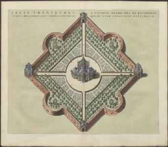
ARCIS VRANIBVRGI, A TYCHONE BRAHE, DNO DE KNVDSTRVP, | IN INSVLA HELLESPONTI DANICI HVENNA CONSTRVCTÆ QUO AD TOTAM CAPACITATEM, DESIGNATIO
[Amsterdam : Joan Blaeu]
ICHNOGRAPHIA PRÆCIPVÆ DOMVS ARCIS VRANIBVRGI | in Insula Porthmi Danici Venusia, Vulgo Huenna, Astronomie instaurande gratia, circa annum MDLXXX. | à TYCHONE BRAHE exædificatæ
[Amsterdam : Joan Blaeu]
Topographia insulae Huenae in celebri porthmo regni Daniae, quem vulgo Oersunt uocant

INSULA HVÆNA, | sive | VENUSIA, | à GVILJELMO BLAEV, | cum sub TYCHONE Astronomiæ | operam daret, delineata.
[Amsterdam : Joan Blaeu]
[Kaart], uit: Danmark 1:100.000 : Generalstabskort
1 : 100000 titelvariant: Generalstabskort; Annotatie: Incompleet; Voor aanwezige bladen zie overzichtsblad Købnhavn : Geodaetisk Institut
Den nordöstlige Deel af Sjælland
1 : 160000 samlet, tegnet og lithogr. af J.H. Mansa [København] : trykt i det Kongl. Steentr.
Strait Denmark-Sweden.
1 : 150000 Nordenankar, J.
Kjöbenhavn 4, uit: Special-Karte von Mittel-Europa / nach amtlichen Quellen bearbeitet von W. Liebenow
1 : 300000 titelvariant: W. Liebenow's Mittel-Europa; Annotatie: Titel boven de bladen: W. Liebenow's Mittel-Europa Johannes Wilhelm Liebenow 1822-1897 Frankfurt a. M. : Ludwig Ravenstein
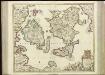
SCANIA | Vulgo | SCHOONEN.
[Amsterdam : Joan Blaeu]
Scania, Vulgo Schonen. [Karte], in: Novus atlas absolutissimus, Bd. 1, S. 122.
1 Karte aus Atlas Janssonius Offizin

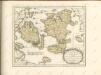
ZEELANDIA | INSVLA | Danicarum Maxima.
[Amsterdam : Joan Blaeu]
Nova et accurata Scaniae et maximae partis Zeelandiae tabula
1 : 325000 A Amsterdam : chez Jean Cóvens et Corneille Mortier
Selandiae In Regno Daniae Insulae Chorographica Descriptio. [Karte], in: Novus atlas absolutissimus, Bd. 1, S. 125.
1 Karte aus Atlas Janssonius Offizin
Zeelandia insvla : Danicarum maxima
1 : 390000 Annotatie: Met opdracht van Joan Blaeu aan Petrus Charisius; Origineel is Blad 145 in atlas factice; Annotatie geografische gegevens: Met schaalstok [Amsterdam] : [Joan Blaeu]
Insvlae Danicae in Mari Balthico sitae utpote Zeelandia, Fionia, Langelandia, Lalandia, Falstria, Fembria Mona repraesentatae
1 : 470000 Baltské moře-oblast Homann, Johann Baptist J.B. Homann
Insvlae Danicae in mari Balthico sitae utpote Zeelandia, Fionia, Langelandia, Lalandia, Falstria, Fembria Mona
1 : 470000 Baltské moře-oblast Homann, Johann Baptist a Ioh. Bapt. Homanno


[67][67] Insularum Danicarum ...., uit: Atlas sive Descriptio terrarum orbis
Annotatie: Gedigitaliseerde versie. Amsterdam. Heiloo : Picturae (vervaardiger), 2015. tiff-bestand. Gedigitaliseerd: 07-01-2015; Origineel: Universiteitsbibliotheek Vrije Universiteit (XL.05127.-) ; Netherlands; Titelpagina ontbreekt Wit, Frederik de Amsterdam : Frederick de Wit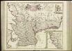
[68][68] Accurata Scaniae, Blekingiae et Hallandiae descriptio, uit: Atlas sive Descriptio terrarum orbis
Annotatie: Gedigitaliseerde versie. Amsterdam. Heiloo : Picturae (vervaardiger), 2015. tiff-bestand. Gedigitaliseerd: 07-01-2015; Origineel: Universiteitsbibliotheek Vrije Universiteit (XL.05127.-) ; Netherlands; Titelpagina ontbreekt Wit, Frederik de Amsterdam : Frederick de Wit

Museumskart 148: Pass Kaart over Kattegatet
1 : 200000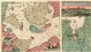
Nieuwe Pascaert van de Sond ende Beldt :
1 : 470000 Mollova mapová sbírka Keulen, Johannes van Keulen, Johannes van II
Nova tabula Scaniae, quae est Gothia australis provincias Scaniam, Hallandiam, et Blekingiam complectens
1 : 560000 Švédsko jižní Homann, Johann Baptist J.B. Homann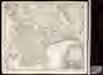
Nova tabula Scaniae / accurate exhibita â Ioh. Bapt. Homanno
1 : 480000 1 Karte : Kupferdruck ; 46 x 55 cm Homann, Johann Baptist [Johann Baptist Homann]
Kongeriget Danmark
1 : 500000 Bornholm (Dánsko) Generalstabens topografiske afdeling