Maps of Utrecht

La Seigneurie d'Utrecht. Dressé sur les memoires les plus nouveaux
1 : 150000 dressé sur les memoires les plus nouveaux par le Sr. Sanson, geographe ordinaire du roy. A Amsterdam : chez Pierre Mortier et compangie
La Seigneurie D'Utrecht [Karte], in: Atlas nouveau, contenant toutes les parties du monde [...], Bd. 2, S. 79.
1 Karte aus Atlas Sanson, Nicolas Jaillot, Alexis Hubert und Mortier, Pieter
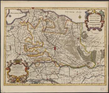
Nieuwe kaart van den Lande van Utrecht
1 : 44000 volgens ordre van d'Ed. Mog. Heeren Staten van welgemelden lande doen meten, en in kaart brengen, door Bernard du Roy G. Hoet, del. ornam. ; T. Doesburgh, sculps. Tot Amsterdam : door Johannes Covens en Cornelis Mortier
Vltraiectvm dominivm
1 : 200000 Utrecht (Nizozemsko) Blaeu, Willem Janszoon Guilielmus Blaeuw

Ultraiectum Dominium
1 : 415000 Petrus Kærius cælavit. [Amsterdam] : [Jan Evertsz. Cloppenburgh]
Kaart van de provincie Utrecht verdeeld in arrondissementen en regterlijke kantons, ingevolge besluit van Z.M. den Koning der Nederlanden = Province d’Utrecht, divisée en arrondissemens et cantons judiciaires par arrêté de S.M. le Roi des Pays-Bas
dressée gravée et publiée par F. Desterbecq, vu par le Cadastre. La Haye : Établissement Géographique de F. Desterbecq
Ultraiectini Dominii tabula / multo aliis auctior et correctior per Nic. Visscher ; R. de Hooghe fecit
1 : 180000 Annotatie: Origineel is Blad 55 in atlas factice; Annotatie geografische gegevens: Zuidwest boven; Met 3 schaalstokken Nicolaes Jansz Visscher sr 1618-1679; Romeyn de Hooghe 1645-1708 [Amsterdam : Nicolaes Visscher]
[99][100] Ultraiectini Dominii tabula, uit: Atlas sive Descriptio terrarum orbis
Annotatie: Gedigitaliseerde versie. Amsterdam. Heiloo : Picturae (vervaardiger), 2015. tiff-bestand. Gedigitaliseerd: 07-01-2015; Origineel: Universiteitsbibliotheek Vrije Universiteit (XL.05127.-) ; Netherlands; Titelpagina ontbreekt Wit, Frederik de Amsterdam : Frederick de Wit
Utrecht, uit: Sterfte-atlas van Nederland over 1860-1874 / [uitgave van de Nederlandsche Maatschappij tot Bevordering der Geneeskunst]
titelvariant: Sterfte-atlas van Nederland; Annotatie: Alleen kaartbijlage aanwezig Pieter Harmen Witkamp 1816-1892; Nederlandsche Maatschappij tot Bevordering der Geneeskunst Amsterdam : van Rossen
La Seigneurie d'Vtrecht
1 : 170000 Mollova mapová sbírka Sanson, Guillaume Jaillot, Alexis Hubert
Ultraiectini Dominii Tabula [Karte], in: Novus atlas absolutissimus, Bd. 3, S. 203.
1 Karte aus Atlas Janssonius Offizin
Ultraiectini Dominii tabula
1 : 120000 multo aliis auctior et correctior per F. de Wit. T'Amsterdam : by J. Covens en C. Mortier
Ultraiectini Dominii tabula
1 : 120000 multo aliis auctior et correctior per I. Danckerts. Tot Amsterdam : by Justus Danckers

Ultraiectini Dominii tabula
1 : 120000 multo aliis auctior et correctior per Nic. Visscher R. de Hooghe fecit. [Amsterdam] : [N. Visscher]
Ultraiectini Dominii tabula multo aliis auctior et correctior
1 : 100000 per F. de Wit. Tot Amsterdam : by Frederick de Wit ...
Dominii Ultraiectini tabula
1 : 110000 auctore Frederico de Wit Amsterodami. tot Amsterdam : by Frederick de Wit, inde Calverstraet by den Dam inde Witte Paskaert
Utrecht, divisé en arrondissemens et cantons de justice de paix
1 : 180000 dressé et gravé par C. van Baarsel et fils. À La Haye : chez F.J. Weygand
Nieuwe kaart van Utrecht behoorende tot het Vaderlandsch woordenboek van Jacobus Kok
1 : 170000 J.C. de Roeder, del. C. van Baarsel, sculp. [Amsterdam] : [by Johannes Allart]
Ultraiectini Dominii Tabula
1 : 120000 Mollova mapová sbírka Wit, Frederik de Covens, Johannes I
Ultraiectini Dominii tabula
1 : 120000 Mollova mapová sbírka Danckerts, Justus Danckerts, Cornelis
ULTRAIECTINI DOMINII TABULA
1 : 120000 Nizozemsko Visscher, Nicolaus Hooghe, Romeyn de per Nic. Visscher
Carte von Utrecht / entworfen von F.L. Güssefeld
1 : 125000 titelvariant: Carte geographique de la Province d'Utrecht; Annotatie: Titel boven de kaart: Carte geographique de la Province d'Utrecht; Annotatie geografische gegevens: West boven Güssefeld, F. L. Nürnberg : bey den Hom. Erben
Ultraiectum Dominium. [Karte], in: Le théâtre du monde, ou, Nouvel atlas contenant les chartes et descriptions de tous les païs de la terre, Bd. 1, S. 441.
1 Karte aus Atlas Blaeu, Willem Janszoon und Blaeu, Joan Blaeu, Willem Janszoon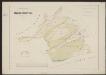
Episcop. Ultraiectinus [Karte], in: Gerardi Mercatoris et I. Hondii Newer Atlas, oder, Grosses Weltbuch, Bd. 1, S. 466.
1 Karte aus Atlas Mercator, Gerhard und Hondius, Jodocus Jansson, Jan
Ultraiectum Dominium. [Karte], in: Theatrum orbis terrarum, sive, Atlas novus, Bd. 1, S. 445.
1 Karte aus Atlas Blaeu, Joan Blaeu, Willem Janszoon
Ultraiectum Dominium. [Karte], in: Novus Atlas, das ist, Weltbeschreibung, Bd. 1, S. 408.
1 Karte aus Atlas Blaeu, Joan Blaeu, Willem Janszoon
Nieuwe kaart van Utrecht behoorende tot het Vaderlandsch woordenboek van Jacobus Kok
1 : 170000 J.C. de Roeder, del. C. van Baarsel, sculp. [Amsterdam] : [by Johannes Allart]