Maps of Gelderland

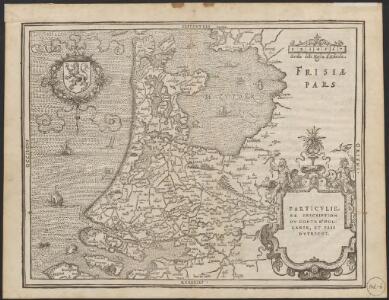
Particuliere description du Conte d'Hollande, et pais d'Utrecht
1 : 650000 [Lodovico Guicciardini] [engraver: Corneel Muller] [Antwerpen] : [Willem Silvius]
Netherlands.
1 : 1180000 Lucas, Fielding Jr.
Nieuwe kaart van Holland
1 : 675000 J.C. de Roeder, delin. H. Klockhoff, dir. sculp. 1792. [Amsterdam] : [Johannes Allart]
Nieuwe kaart van Holland tot het Vaderlandsch Woordenboek van Kok behoorende
1 : 675000 J.C. de Roeder, delin. H. Klockhoff, dir. sculp. 1792. [Amsterdam] : [Johannes Allart]
Holland
1 : 800000 [Franz Johann Joseph von Reilly] [Wien] : [Franz Johann Joseph von Reilly]

Comitatus Hollandiæ tabula pluribus locis recens
1 : 300000 pluribus locis recens emendata a Nicolao Visscher. [Amsterdam] : nunc apud Petrum Schenk junior
Comitatus Hollandiae Tabula Pluribus Locis [...] [Karte], in: Novus atlas absolutissimus, Bd. 3, S. 162.
1 Karte aus Atlas Janssonius Offizin
Comitatus Hollandiae pluribus locis recens emendata / a Frederico de Wit
1 : 300000 Annotatie: Deze derde staat van de koperplaat is te herkennen aan het cijfer "I" rechtsboven (net als de tweede staat) en aan het feit dat de plattegrond van Amsterdam is ingevuld (bij de eerste en tweede staat van de koperplaat is dit niet het geval); Annotatie geografische gegevens: West boven Wit, Frederik de Amsterdam : Frederick de Wit
Comitatus Hollandiæ tabula denuo in lucem
1 : 300000 edita à Carolo Allard Amstelodami. 't Amsterdam : gedruckt by, Carel Allard. caart en constverkooper op den Dam inde Caartwinkel
Comitatus Hollandiæ tabula pluribus locis recens
1 : 300000 pluribus locis recens emendata a Francisco Caroli J. Bormeester. eccu. Amstel' : Petrum Schenk exc.
Condado de Olanda
1 : 1000000 [Jacques Harrewijn] [Madrid] : [Francisco Laso]
Comitatus Hollandiæ tabula pluribus locis recens
1 : 320000 pluribus locis recens emendata a Justo Danckerts. [Amsterdam] : Justus Danckerts
Comitatus Hollandiae Nova Descriptio. Ex Optimis & novißimis Delineationibus designata [Karte], in: Novus atlas absolutissimus, Bd. 3, S. 159.
1 Karte aus Atlas Janssonius Offizin
Charte von Holland
1 : 300000 nach astronomischen Beobachtungen, den Messungen des Schnellius &.c.c. und den vorzüglichsten Specialcharten neu entworfen von F.L. Güssefeld. Nürnberg : bey den Hom[ännischen Erben]
Comitatus Hollandiæ tabula pluribus locis recens
1 : 300000 pluribus locis recens emendata a Frederico de Wit. Gedruckt 't Amsterdam : by Frederick de Wit ...
Comitatus Hollandiae tabula / pluribus locis recens emendata a Nicolao I. Visschero
1 : 300000 Annotatie: Origineel is Blad 50 in atlas factice; Annotatie geografische gegevens: West boven Visscher, Claes Jansz. [Amsterdam : C.J. Visscher excudit]
Comitatus Hollandiæ nova descriptio, ex optimis & novißimis delineationibus designata
1 : 350000 Geeraerd Coeck sculpsit. Amstelodami : apud Joannem Janssonium
Nuova carta della contea di Olanda
1 : 700000 Frano. Sesone sculp. [Napoli] : [Francesco Ricciardo]
Comitatus Hollandiae tabula
1 : 300000 pluribus locis recens emendata a Frederico de Wit. [Amsterdam] : ex officina I. C
Comitatus Hollandiae tabula
1 : 300000 pluribus locis recens emendata a Nicolao Visscher. [Amsterdam : Nicolaus Visscher]
HOLLANDIA | COMITATVS
Apud Guiljelmum Blaeu
Comitatus Hollandiæ
1 : 980000 Harrewijn fecit. [Antwerpen] : J. Peeters. ex.
Nuova carta della contèa di Olanda
1 : 700000 [Giambatista Albrizzi] [Venezia] : [Giambatista Albrizzi]
Comitatus Hollandiæ novissima descriptio
1 : 360000 designatore Balthazaro Florentio a Berckenrode Salomon Rogiers sculpsit. Amstelodami : sumptibus Henrici Hondii ...
Hollandia Comitatus
1 : 520000 [Caspar Merian] [Frankfurt am Main] : Caspar Merian]
Hollandia Comitatus
1 : 360000 [Cornelis Danckerts jr.] Amstelodami : apud Cornelio Dankero
Comitatus Hollandiæ novissima descriptio
1 : 360000 designatore Balthazaro Florentio a Berckenrode Salomon Rogiers sculpsit. Amstelodami : sumptibus Joannis Janssonii
Nieuwe kaart der provincie van Holland
1 : 450000 Annotatie: Oorspronkelijk verschenen in: Hedendaegsche historie, of Tegenwoordige staet van alle volkeren / Jan Wagenaar, dl. XIV. - Amsterdam : Isaak Tirion, 1742; Ook verschenen in: Nieuwe handatlas ... - Amsterdam : Isaak Tirion, 1744, of latere editie Te Amsterdam : by Isaak Tirion