Maps of Arnold

Duluth
1 : 24000
Duluth
1 : 24000
Duluth
1 : 24000
Duluth
1 : 24000
Duluth
1 : 24000
Duluth
1 : 24000
Duluth
1 : 24000
Duluth
1 : 62500
Duluth
1 : 62500
Duluth
1 : 62500
Duluth
1 : 62500
Duluth
1 : 62500
Duluth
1 : 62500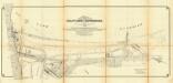
Map of the harbor at Duluth, Minn., and Superior, Wis. progress sheet no. 1 : dredging district N21 and easterly portion of district N22
1 : 16000 This map shows blocks, industrial buildings, and railroads in portions of Duluth and Superior, as well as harbor lines, areas improved, and proposed improvements "under present project" in Superior Bay, Allouez Bay, and part of St. Louis Bay. Depths are shown by soundings and isolines. North is oriented to the upper left. The top of the map reads: "Soundings are in feet and reduced to low water datum," and the bottom right margin reads: "To accompany my report for the fiscal year ending June 30th, 1898." United States. Army. Corps of Engineers U.S. Engineer Office
Chart of Harbor at Duluth, Minn. and Superior, Wisconsin / prepared and first issued under the directions of Colonel J.C. Sanford, and Lieut. Colonel Mason M. Patrick, Corps of Engineers, U.S. Army, in 1914-1915. , Second ed. / rev. and published under the direction of F.G. Ray.
1 : 24000 This map shows details of the harbor, proposed route and bridge changes, railroads, streets, selected buildings, a portion of Lake Superior and other lakes, bays, and rivers in portions of Duluth and Superior. Depths are shown by soundings, contours, and tints. Also included are notes on sailing directions, the water levels of Lake Superior, dry docks, opening and closing of navigation, abbreviations, and uncompleted sketches of McDougall-Duluth Ship Yard piers and Zenith Furnace Co’s pier. The left margin of the map reads:"Issued May 27, 1919 (1200)." United States. War Dept. Corps of Engineers United States. War Dept. Corps of Engineers
Chart of harbor at Duluth, Minn. and Superior, Wisconsin / prepared under the direction of Major W.L. Fisk, Corps of Engineers, U.S. Army, in 1902-1905.
1 : 18000 This map shows streets, industrial buildings, a portion of Lake Superior and other lakes, bays, and rivers in portions of Duluth and Superior. Relief is shown by hachures; depths are shown by tints, soundings and isolines. The map is continued by an inset that shows the St. Louis River from Mud Lake to foot of rapids. Also included are notes on sailing directions, the water levels of Lake Superior, dry docks, opening and closing of navigation and abbreviations. North is oriented to the upper right. The lower left of the map reads: "Prepared under the direction of Major W.L. Fisk Corps Engineers, U.S. Army, in 1902-1905." Also noted are the dates of additions and corrections and authorities the surveys were made under. United States. War Dept. Corps of Engineers United States. War Dept. Corps of Engineers
Chart of harbor at Duluth, Minn. and Superior, Wis. / prepared under the direction of Major W.L. Fisk, Corps of Engineers, U.S.A.
1 : 18000 This map shows streets, industrial buildings, a portion of Lake Superior and other lakes, bays, and rivers in portions of Duluth and Superior. Relief is shown by hachures; depths are shown by tints, soundings and isolines. The map is continued by an inset that shows the St. Louis River from Mud Lake to foot of rapids. Also included are notes on the water levels of Lake Superior, dry docks at West Superior, opening and closing of navigation and abbreviations of lights and buoys. North is oriented to the upper right. The lower left of the map reads: "Prepared under the direction of Major W.L. Fisk Corps Engineers, U.S.A, from surveys made under the direction of Major Clinton B. Sears, Corps of Engineers, U.S.A., in 1901." United States. Army. Corps of Engineers United States. Army. Corps of Engineers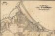
Map of the city of Superior, Douglas County, Wis.
1 : 28800 This map shows streets, railroads, dock and harbor lines, and parks. The map includes population tables for 1880, 1890, 1900.
Duluth
1 : 100000
Duluth
1 : 250000
Duluth
1 : 250000
Duluth
1 : 250000
[Coteau des prairies, M'dewakaton country, Warpekutey country, Winebago Indian country, Iowa Territory; middle right.] / by J.N. Nicollet, made in the years 1836, 37, 38, 39 & 40 ; assisted in 1838, 39 & 40 by Lieut. J.C. Frémont of the Corps of Topog...
From Map of the hydrographical basin of the upper Mississippi River : from astronomical and barometrical observations, surveys and information
Educational map of the state of Wisconsin
1 : 380160 This map is ink on paper and shows the location of various types of schools. The map includes text about the school system and tables of statistics (1849-1875) including: Number of children-attendance -- Apportionment of state money -- School houses -- Annual expenses -- Teachers and certificates -- Teachers' wages -- Territorial divisions -- Statistics for 1875 -- Statistics of cities. The map also includes illustrations of: River Falls Normal School -- Oshkosh Normal School -- Platteville Normal School -- University of Wisconsin (Ladies Hall, S. Dormitory, University Hall, N. Dormitory) -- Science Hall (University of Wisconsin) -- Whitewater Normal School. Searing, Edward
A Geological Map of Wisconsin
1 : 1710720 This map shows counties, cities, rivers, canals, lakes, railroads, common roads, county towns, townships, villages, and post offices. The map includes part of the upper peninsula of Michigan. Lapham, Increase Allen
Map of Northern Minnesota, 1874.
1 : 760320 Andreas, A. T. (Alfred Theodore), 1839-1900
Wisconsin.
1 : 1340000 Mitchell, Samuel Augustus
Wisconsin.
1 : 1030000 Rand McNally and Company
Wisconsin.
1 : 2100000 Rand McNally and Company
Climatological map of Wisconsin.
1 : 1520640 Snyder, Van Vechten & Co.
Map of the State of Wisconsin.
1 : 1140480 Snyder, Van Vechten & Co.
State of Wisconsin.
1 : 760320 U.S. General Land Office
Geological map of Wisconsin.
1 : 1520640 Snyder, Van Vechten & Co.
Map of Wisconsin showing congressional and judicial districts.
1 : 1520640 Snyder, Van Vechten & Co.
Map of Wisconsin showing senatorial districts.
1 : 1520640 Snyder, Van Vechten & Co.
Map of Wisconsin, showing assembly districts.
1 : 1520640 Snyder, Van Vechten & Co.
Wisconsin.
1 : 1330560 Cram Atlas Company
Wisconsin.
1 : 1140480 U.S. General Land Office

