Maps of Evanston

Evanston
1 : 62500
Evanston
1 : 62500
Evanston
1 : 62500
Evanston
1 : 24000
Evanston
1 : 24000
Evanston
1 : 24000
Evanston
1 : 24000
Evanston
1 : 24000
Evanston
1 : 24000
Evanston
1 : 24000
Evanston
1 : 24000
Evanston
1 : 24000
Evanston
1 : 24000
Evanston
1 : 24000
Railway Terminal Map of Chicago.
1 : 85000 Rand McNally and Company
Chicago and vicinity, Ill.-Ind. : 1953
1 : 24000 Geological Survey (U.S.) The Survey
Blanchard's map of Chicago and suburbs
Blanchard, Rufus, 1821-1904 Rufus Blanchard
Rand McNally & Co.'s new street number guide map of Chicago : Northern sheet
1 : 37500 Rand McNally and Company Rand McNally & Co.
Rand McNally & Co.'s new street number guide map of Chicago : Southern sheet
1 : 37500 Rand McNally and Company Rand McNally & Co.
[Recto], uit: Rand, McNally & Co.'s new street number guide map of Chicago
1 : 25000 titelvariant: Rand, McNally & Company's souvenir guide to Chicago; Annotatie: Bijl. bij: Rand, McNally & Company's souvenir guide to Chicago; Met lijst van spoorwegen; Annotatie geografische gegevens: Kaartbeeld op recto: noordelijk deel van Chicago, op verso: zuidelijk deel van Chicago [S.l. : Rand, McNally & Co.]
Surficial geology of the Chicago Loop quadrangle
1 : 24000 Bretz, J. Harlen, 1882-1981 State Geological Survey Division
Shell Metropolitan Chicago and Vicinity.
1 : 205920 Shell Oil Company
Racine
1 : 250000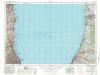
Racine
1 : 250000
Racine
1 : 250000
Racine
1 : 250000
Chicago District.
1 : 380000 Rand McNally and Company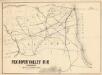
Fox River Valley R.R. in Wisconsin with its connections.
1 : 1600000 This hand colored map shows southern Wisconsin and northern Illinois and indicates county boundaries, larger cities, and some drainage. The line was chartered in 1852 and constructed in 1854. Lipman & Riddle Lipman & Riddle Lith
AutoTrails Map, Illinois, Western Indiana, Southeast Iowa, Northeast Missouri.
1 : 783000 Rand McNally and Company

