Maps of West Islip

Bay Shore West
1 : 24000
Bay Shore West
1 : 24000
Bay Shore West
1 : 24000
Bay Shore West
1 : 24000
Bay Shore West
1 : 24000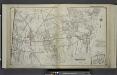
Part of Town Babylon
from Atlas of ... Suffolk County, Long Island, New York ... : based upon actual measurements by our own corps of engineers, maps on file at county offices, also maps from actual surveys furnished by individual owners / under the supervision of Merritt B. Hyde.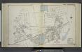
Part of Babylon
from Atlas of ... Suffolk County, Long Island, New York ... : based upon actual measurements by our own corps of engineers, maps on file at county offices, also maps from actual surveys furnished by individual owners / under the supervision of Merritt B. Hyde.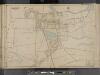
Suffolk County, V. 1, Double Page Plate No. 10 [Map bounded by Little East Neck Rd., Great Neck Rd., Southard Lane] / supplemented by careful measurements & field observations by our own Corps of Engineers.
From Vol. 1, South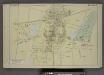
Babylon. [Village]
from Atlas of the towns of Babylon, Islip, and south part of Brookhaven in Suffolk Co., N.Y. Published by Wendelken & Co., 36 Vesey street, New York ... Engraved and printed by L.E. Neuman & Co.
Babylon
1 : 62500
Babylon
1 : 62500
Babylon
1 : 62500
Babylon
1 : 62500
Babylon
1 : 62500
Babylon
1 : 62500
Babylon
1 : 62500
Babylon
1 : 62500
Babylon
1 : 62500
Babylon
1 : 62500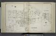
Lindenhurst; Wyandanch
from Atlas of ... Suffolk County, Long Island, New York ... : based upon actual measurements by our own corps of engineers, maps on file at county offices, also maps from actual surveys furnished by individual owners / under the supervision of Merritt B. Hyde.
Breslau. [Village]
from Atlas of the towns of Babylon, Islip, and south part of Brookhaven in Suffolk Co., N.Y. Published by Wendelken & Co., 36 Vesey street, New York ... Engraved and printed by L.E. Neuman & Co.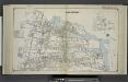
Bayshore
from Atlas of ... Suffolk County, Long Island, New York ... : based upon actual measurements by our own corps of engineers, maps on file at county offices, also maps from actual surveys furnished by individual owners / under the supervision of Merritt B. Hyde.
Brentwood. [Village]; Greenville. [Village]; Bayshore [Village]
from Atlas of the towns of Babylon, Islip, and south part of Brookhaven in Suffolk Co., N.Y. Published by Wendelken & Co., 36 Vesey street, New York ... Engraved and printed by L.E. Neuman & Co.
Bayshore, Town of Islip, Suffolk Co. - Brentwood, Town of Islip, Suffolk Co. - Bohemia, Town of Islip, Suffolk Co. - Greenville, Town of Islip, Suffolk Co. - Happauge, Town of Smithtown & Islip, Suffolk Co.
from Atlas of Long Island, New York. From recent and actual surveys and records.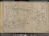
Suffolk County, V. 1, Double Page Plate No. 1 [Map bounded by Town of Huntington, Town of Islip, Great South Bay, Nassau County, Lindenhurst] / supplemented by careful measurements & field observations by our own Corps of Engineers.
From Vol. 1, South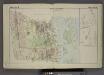
Town of Babylon. [Township]; Map of Oak & Cap Islands and Beach.
from Atlas of the towns of Babylon, Islip, and south part of Brookhaven in Suffolk Co., N.Y. Published by Wendelken & Co., 36 Vesey street, New York ... Engraved and printed by L.E. Neuman & Co.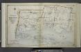
Index Map No.1 of a part of Suffolk County. South Side - Ocean Shore, Long Island. Townships of Babylon and Part of Islip Published by E. Belcher Hyde. 97 Liberty Street, Brooklyn. 5 Beekman Street, Manhattan. 1915. Volume One.
from Atlas of ... Suffolk County, Long Island, New York ... : based upon actual measurements by our own corps of engineers, maps on file at county offices, also maps from actual surveys furnished by individual owners / under the supervision of Merritt B. Hyde.
Islip
1 : 125000
Islip
1 : 125000
Islip
1 : 125000
Islip
1 : 125000
Islip
1 : 125000

