Maps of Olsburg
Randolph
1 : 20000
Olsburg SW
1 : 24000
Olsburg SW
1 : 24000
Olsburg SW
1 : 24000
Tuttle Creek Dam
1 : 24000
Tuttle Creek Dam
1 : 24000
Olsburg NW
1 : 24000
Olsburg NW
1 : 24000
Olsburg NW
1 : 24000
Olsburg
1 : 24000
Olsburg
1 : 24000
Olsburg
1 : 24000
Junction City
1 : 125000
Junction City
1 : 125000
Junction City
1 : 125000
Junction City
1 : 125000
Junction City
1 : 125000
Junction City
1 : 125000
Junction City
1 : 125000
Junction City
1 : 125000
Junction City
1 : 125000
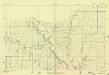
Riley Co. and Randolph, Cleburne, Leondardville and Ogden, Kansas.
1 : 126720 L.H. Everts & Co.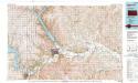
Manhattan
1 : 100000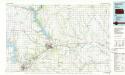
Manhattan
1 : 100000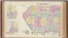
Pottawatomie Co., Onaga and Westmoreland, Kansas.
1 : 126720 Mann, Adin, 1816-1903
Manhattan
1 : 250000
Manhattan
1 : 250000
Manhattan
1 : 250000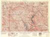
Manhattan
1 : 250000

