Maps of Pittsylvania County

Callands
1 : 62500
Callands
1 : 62500
Callands
1 : 62500
Callands
1 : 62500
Callands
1 : 48000
Callands
1 : 24000
Mountain Valley
1 : 24000
Callands
1 : 24000
Callands
1 : 24000
Mountain Valley
1 : 24000
Mountain Valley
1 : 24000
Sandy Level
1 : 24000
Sandy Level
1 : 24000
Penhook
1 : 24000
Penhook
1 : 24000
Sandy Level
1 : 24000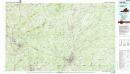
Danville
1 : 100000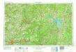
Greensboro
1 : 250000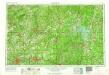
Greensboro
1 : 250000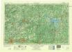
Greensboro
1 : 250000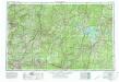
Greensboro
1 : 250000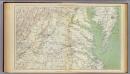
Gen. map II.
1 : 633600 United States. War Department
War telegram marking map
1 : 490000 L. Prang & Co Lith. of J. Bien
Virginia and Maryland
1 : 1500000 Maryland Heřman, Augustin Faithorne, Henry Aug. Herman and Thomas Withinbrook
Map to illustrate the 1862 (Virginia) Campaign
Map to illustrate the 1862 (Virginia) Campaign. Map to illustrate the American Civil War of sixty years previously. This small map details the areas of Virginia around the capitals of Washington, D.C. and Richmond where a great amount of fighting took place in 1862 and indeed across the war period. Several places on the map, such as Fredericksburg, Petersburg and Manassas Junction/Bull Run witnessed heavy clashes during the conflict. The map also details railway routes in the region. War Office
Richardson's Map Of West Virginia.
1 : 760320 Richardson, C.S.
Prang's Naval Expedition Maps: North Carolina coast line
Prang's Naval Expedition Maps: North Carolina coast line L. Prang & Co.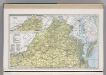
Virginia.
1 : 1271000 Hammond, C.S.
Shell Highway Map of Delaware - Maryland, Virginia, W. Virginia. (eastern portion).
1 : 950400 Shell Oil Company

