Maps of Saratoga Springs

Corinth
1 : 24000
Corinth
1 : 24000
Corinth [Township]; Palmer Falls Business Directory.
from New topographical atlas of Saratoga Co., New York, from actual surveys by S. N. & D. G. Beers and assistants.
Wilton [Township]
from New topographical atlas of Saratoga Co., New York, from actual surveys by S. N. & D. G. Beers and assistants.
Beechers Hollow [Village]; Beechers Hollow Business Directory. ; Batchellorville Business Directory. ; Wilton [Village]; Wilton Business Directory. ; Porters [Village]; Porters Corners Business Directory. ; Batchellorville [Village]; Galway Business Dire
from New topographical atlas of Saratoga Co., New York, from actual surveys by S. N. & D. G. Beers and assistants.
Saratoga
1 : 62500
Saratoga
1 : 62500
Saratoga
1 : 62500
Saratoga
1 : 62500
Saratoga
1 : 62500
Saratoga
1 : 62500
Saratoga
1 : 62500
Saratoga
1 : 62500
Saratoga
1 : 62500
Saratoga
1 : 62500
Saratoga
1 : 62500
Saratoga
1 : 62500
Saratoga
1 : 62500
Greenfield [Township]; Pages Corners Business Directory.
from New topographical atlas of Saratoga Co., New York, from actual surveys by S. N. & D. G. Beers and assistants.
Wilton, Saratoga County, New York.
1 : 42240 Beers, B.G.
Saratoga Springs [Township]
from New topographical atlas of Saratoga Co., New York, from actual surveys by S. N. & D. G. Beers and assistants.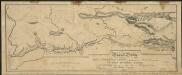
Map and profile of the Champlain Canal as made from Lake Champlain to the Hudson River and surveyed thence to the tide at Waterford
1 : 190080 Geddes, James
Saratoga County.
1 : 151000 Burr, David H., 1803-1875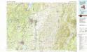
Glens Falls
1 : 100000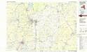
Glens Falls
1 : 100000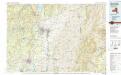
Glens Falls
1 : 100000
Hudson River & vicinity / drawn by David H. Burr ; S. Stiles & Co., N.Y.
from Hudson River
Map of Saratoga County
from New topographical atlas of Saratoga Co., New York, from actual surveys by S. N. & D. G. Beers and assistants.
Map of the county of Saratoga / by David H. Burr ; engd. by Rawdon, Clark & Co., Albany, & Rawdon, Wright & Co., N. York.
from An atlas of the state of New York : containing a map of the state and of the several counties / by David H. Burr.

