Maps of Sweetwater County

Point Of Rocks SW
1 : 24000
Point Of Rocks SW
1 : 24000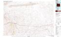
Red Desert Basin
1 : 100000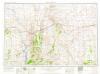
Rock Springs
1 : 250000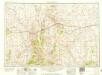
Rock Springs
1 : 250000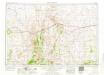
Rock Springs
1 : 250000
Rock Springs
1 : 250000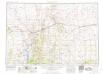
Rock Springs
1 : 250000
Structure sections through the Uinta Mountains.
1 : 253440 Powell, John Wesley, 1834-1902
Green River from the Union Pacific Rail Road to White River (geology)
1 : 253440 Thompson, A. H. (Almon Harris), 1839-1906
Green River from the Union Pacific Rail Road to White River (land cover)
1 : 253440 Thompson, A. H. (Almon Harris), 1839-1906
Displacement diagrams ... through the Uinta Mountains.
1 : 253440 Powell, John Wesley, 1834-1902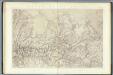
Green River Basin. (Topographical)
1 : 253440 King, Clarence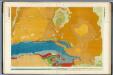
Green River Basin. (Geological)
1 : 253440 King, Clarence
Campaign map of the department of the Platte. sheet no. 4 : comprising that portion of Wyoming
1 : 600000 Jones, William Albert 1841-1914; États-Unis. Corps of Engineers [Omaha, Nebr.] : Engineer Dept., U.S. Army
From the Valley of Green River to Great Salt Lake.
1 : 760320 Beckwith, E.G.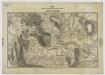
Map of the Military Department of the Platte, Wyoming. sheet no. 3
1 : 1200000 Jones, William Albert 1841-1914 [Omaha, Nebr.] : [Engineer Dept., U.S. Army]
Holt's New Map Of Wyoming.
1 : 760320 Holt, George L.
Wyoming.
1 : 1500000 Rand McNally and Company
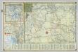
Territory of Wyoming, Alabama, Louisiana, Kansas.
Arbuckle Bros.
Wyoming.
1 : 1800000 Mitchell, Samuel Augustus
Wyoming.
1 : 2100000 Rand McNally and Company
Territory Of Wyoming.
1 : 950400 U.S. General Land Office
Wyoming.
1 : 1330560 Cram Atlas Company
Utah.
1 : 950000 Rand McNally and Company
Utah.
1 : 1820000 Cram, George Franklin; Davis, Ellis Arthur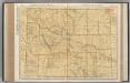
Wyoming.
1 : 982000 Rand McNally and Company
From the Coo-che-to-pa Pass to Wahsatch Mountains.
1 : 760320 Gunnison, J.W.
Utah.
1 : 1574000 Gray, Ormando Willis