Maps of Shaftsbury

Arlington
1 : 24000
Arlington
1 : 24000
Arlington
1 : 24000
Equinox
1 : 62500
Equinox
1 : 62500
Equinox
1 : 62500
Equinox
1 : 62500
Equinox
1 : 62500
Equinox
1 : 62500
Equinox
1 : 62500
Equinox
1 : 62500
Equinox
1 : 62500
Equinox
1 : 62500
Shaftsbury and Glastenbury, Bennington County, Vermont.
1 : 42240 Beers, Frederick W.
Plan of Bennington County, Vermont.
1 : 190080 H.W. Burgett and Company
Map of the county of Montgomery and Fulton / by David H. Burr; engd. by Rawdon, Clark & Co., Alby., & Rawdon, Wright & Co., N. York.; An atlas of the state of New York, designed for the use of engineers, containing a map of the state and of the several counties. / Projected and drawn ... under the superintendence and direction of Simeon de Witt.
from An atlas of the state of New York, designed for the use of engineers, containing a map of the state and of the several counties. / Projected and drawn ... under the superintendence and direction of Simeon de Witt. Burr, David H.; De Witt, Simeon; Rawdon, Clark & Co.; Rawdon, Wright & Co.; Stone & Clark Republishers,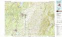
Glens Falls
1 : 100000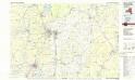
Glens Falls
1 : 100000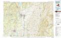
Glens Falls
1 : 100000
Map of the County of Rensselaer / by David H. Burr ; engd. by Rawdon, Clark & Co., Albany, & Rawdon, Wright & Co., New York.
from An atlas of the state of New York : containing a map of the state and of the several counties. / Projected and drawn under the superintendence and direction of Simeon de Witt ... And also the physical geography of the State ...
Map of the county of Rensselaer / by David H. Burr ; engd. by Rawdon, Clark & Co., Albany, & Rawdon, Wright & Co., New York.
from An atlas of the state of New York, designed for the use of engineers, containing a map of the state and of the several counties. / Projected and drawn ... under the superintendence and direction of Simeon de Witt.
Glens Falls
1 : 250000
Glens Falls
1 : 250000
Glens Falls
1 : 250000
Glens Falls
1 : 250000
Glens Falls
1 : 250000
Glens Falls
1 : 250000
Glens Falls
1 : 250000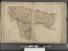
New York State, Double Page Plate No. 12 [Map of Albany, Rensselaer and Columbia Counties]
From Atlas of the State of New York

