Maps of Coastal Plain

Southwest Pass
1 : 62500
Southwest Pass
1 : 62500
Southwest Pass
1 : 62500
Burrwood Bayou West
1 : 24000
Burrwood Bayou East
1 : 24000
Burrwood Bayou West
1 : 24000
Burrwood Bayou East
1 : 24000
Burrwood Bayou East
1 : 24000
Mudpan Bayou
1 : 31680
Burrwood
1 : 31680
Mudpan Bayou
1 : 31680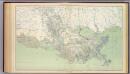
Gen. map XXI.
1 : 633600 United States. War Department
Map of the province of West Florida
1 : 2450000 Kitchin, Thomas Baldwin, Richar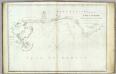
The coasts of West Florida, Alabama, Mississippi & Louisiana.
1 : 680000 Gauld, George.
Louisiana.
1 : 1500000 Colton, G.W.
Louisiana.
1 : 1800000 Cram, George Franklin; Davis, Ellis Arthur
Louisiana.
1 : 1500000 Colton, G.W.
Schonberg's Map of Louisiana.
1 : 1900000 Schonberg & Co.
Louisiana.
1 : 1600000 Colton, G.W.
Special -Karte der Vereinigten Staaten von Nord - America No 14.

Neueste Karte von Louisiana mit seinen Canaelen, Strassen, Eisenbahnen, Entfernungen der Hauptpunkte und Routen für Dampfschiffe
Grosser Hand-Atlas über alle Theile der Erde in 170 Karten Meyer, J. Verlag des Bibliographischen Instituts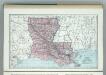
Louisiana.
1 : 1788000 Hammond, C.S.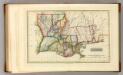
Louisiana.
1 : 1970000 Lucas, Fielding Jr.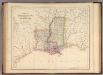
States Of Mississippi And Louisiana.
1 : 3453120 Rogers, Henry Darwin
Course of the River Mississipi from the Balise to Fort Chartres, taken on Expedition to the Illinois
1 carta fluvial. Liutt. Rofs of the 34th Regiment; Sayer, Robert Rob. Sayer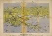
Panorama of the Seat of War. Bird's-eye View of Louisiana, Mississippi, Alabama and part of Florida. Drawn from nature by J. Bachmann.
Panorama of the Seat of War. Bird's-eye View of Louisiana, Mississippi, Alabama and part of Florida. Drawn from nature by J. Bachmann. This 1861 map presents a ‘Bird’s Eye View’ of the Gulf region around Louisiana, Mississippi, Alabama and the edge of Florida. Drawn and published by John Bachmann, the map details numerous strategic forts around this region, including Forts Pickens, Phillip and Jackson, as well as the city of New Orleans. The map highlights how important water routes and control of coastal defences were by both sides during the conflict.
Mississippi, Alabama, Florida, Georgia.
1 : 1584000 Smith, J. Calvin
Louisiana.
from Carey's general atlas, improved and enlarged : being a collection of maps of the world and quarters, their principal empires, kingdoms, &c.
Mississippi & Lousiana.
1 : 2150000 Black, Adam & Charles

