Maps of Chihuahuan Desert
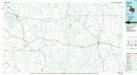
Ozona
1 : 100000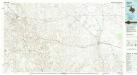
Ozona
1 : 100000
Sheffield
1 : 125000
Horsehead Canyon
1 : 24000
Dead Man Canyon
1 : 24000
Sheffield SE
1 : 24000
Burnt Canyon
1 : 24000
Hunt Ranch
1 : 24000
Mitchell Canyon
1 : 24000
Baggett Ranch
1 : 24000
Ozona SE
1 : 24000
Ozona SE
1 : 24000
Sheffield NW
1 : 24000
Sheffield NW
1 : 24000
Sheffield
1 : 24000
Fort Lancaster
1 : 24000
Bachelor Hill
1 : 24000
Pikes Peak
1 : 24000
Mitchell Canyon NE
1 : 24000
Pikes Peak
1 : 24000
Ozona
1 : 24000
Ozona
1 : 24000
Crockett Heights
1 : 24000
Crockett Heights
1 : 24000
Divide Country
1 : 24000
Divide Country
1 : 24000
Owens Creek SW
1 : 24000
Deer Canyon
1 : 24000
Owens Creek SE
1 : 24000
Schneeman Draw SW
1 : 24000
Schneeman Draw SE
1 : 24000
Indio Hill
1 : 24000
Double Mill Draw SE
1 : 24000

