Maps of Jefferson County

Galloo Island
1 : 24000
Galloo Island
1 : 24000
Galloo Island
1 : 31680
Stony Island
1 : 62500
Stony Island
1 : 62500
Stony Island
1 : 62500
Stony Island
1 : 62500
Stony Island
1 : 62500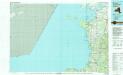
Pulaski
1 : 100000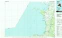
Pulaski
1 : 100000
Map of Jefferson County, New York.
from New topographical atlas of Jefferson Co., New York : From actual surveys / by S.N. & D.G. Beers and assistants.
East End of Lake Ontario.
1 : 633600 Melish, John
East End of Lake Ontario.
1 : 633600 Melish, John
Oswego County.
from Atlas of New York.
Rochester
1 : 250000
Rochester
1 : 250000
Rochester
1 : 250000
Rochester
1 : 250000
Rochester
1 : 250000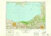
Rochester
1 : 250000
East End of Lake Ontario and River St. Lawrence from Kingston to French Mills.
1 : 360000 Melish, John
East End of Lake Ontario and River St Lawrence.
1 : 348480 Melish, John
Hamilton County.
from Atlas of New York.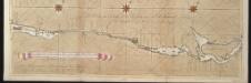
La riviere de Canada ou de St. Laurens de I. de Montreal jusqu'à le lac Ontario aux Nord de l'Amérique
Canada Gerard van Keulen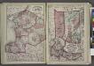
"Jefferson, Oswego, and Lewis Counties"
from New topographical atlas and gazetteer of New York, comprising a topographical view of the several counties of the state, ... including ... map of the United States and territories ... Compiled from the latest astronomical observations, official surveys and records of the United States and territories ...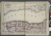
"Niagara, Orleans, Genesee, Monroe, and Wayne counties"
from New topographical atlas and gazetteer of New York, comprising a topographical view of the several counties of the state, ... including ... map of the United States and territories ... Compiled from the latest astronomical observations, official surveys and records of the United States and territories ...
Watertown. [Township]
from New topographical atlas of Jefferson Co., New York : From actual surveys / by S.N. & D.G. Beers and assistants.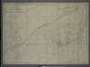
Survey of the several routes for a rail road from Ogdensburgh to Lake Champlain : made in pursuance of an act of the State of New York, passed May 14th, 1840 / by Edw H. Brodhead, chief engineer ; J.H. Jackson, H. Thomas & V. Whitney, commissrs.
from (A-Z)
New York.
1 : 614000 Hammond, C.S.

