Maps of Herkimer County

Van Hornesville
1 : 31680
Van Hornesville
1 : 24000
Van Hornesville
1 : 24000
Richfield Springs
1 : 62500
Richfield Springs
1 : 62500
Richfield Springs
1 : 62500
Richfield Springs
1 : 62500
Richfield Springs
1 : 62500
Richfield Springs
1 : 62500
Montgomery County.
1 : 151000 Burr, David H., 1803-1875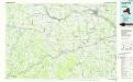
Amsterdam
1 : 100000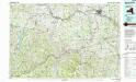
Amsterdam
1 : 100000
Map of the county of Madison / by David H. Burr; engd. by Rawdon, Clark & Co., Albany, & Rawdon, Wright & Co., N.Y.; An atlas of the state of New York: containing a map of the state and of the several counties / by David H. Burr.
from An atlas of the state of New York : containing a map of the state and of the several counties / by David H. Burr. Burr, David H.; Rawdon, Clark & Co.; Rawdon, Wright & Co.; Stone & Clark Republishers,
Map of the county of Madison / by David H. Burr; engd. by Rawdon, Clark & Co., Albany, & Rawdon, Wright & Co., N.Y.; An atlas of the state of New York, designed for the use of engineers, containing a map of the state and of the several counties. / Projected and drawn ... under the superintendence and direction of Simeon de Witt.
from An atlas of the state of New York, designed for the use of engineers, containing a map of the state and of the several counties. / Projected and drawn ... under the superintendence and direction of Simeon de Witt. Burr, David H.; De Witt, Simeon; Rawdon, Clark & Co.; Rawdon, Wright & Co.; Stone & Clark Republishers,
Map of the county of Madison / by David H. Burr; engd. by Rawdon, Clark & Co., Albany, & Rawdon, Wright & Co., N.Y.; An atlas of the state of New York: containing a map of the state and of the several counties. / Projected and drawn under the superintendence and direction of Simeon de Witt ... And also the physical geography of the State ...
from An atlas of the state of New York : containing a map of the state and of the several counties. / Projected and drawn under the superintendence and direction of Simeon de Witt ... And also the physical geography of the State ... Burr, David H.; De Witt, Simeon,
Outline Map of Fulton Co. New York.
from Atlas of Montgomery and Fulton counties, New York. From actual surveys / by and under the direction of B. Nichols ; assisted by H.B. Stranahan ... [et al.]
Map of the county of Onondaga / by David H. Burr; engd. by Rawdon, Clark & Co., Albany, & Rawdon, Wright & Co., New York.; An atlas of the state of New York: containing a map of the state and of the several counties / by David H. Burr.
from An atlas of the state of New York : containing a map of the state and of the several counties / by David H. Burr. Burr, David H.; Rawdon, Clark & Co.; Rawdon, Wright & Co.; Stone & Clark Republishers,
Map of the county of Onondaga / by David H. Burr; engd. by Rawdon, Clark & Co., Albany, & Rawdon, Wright & Co., New York.; An atlas of the state of New York, designed for the use of engineers, containing a map of the state and of the several counties. / Projected and drawn ... under the superintendence and direction of Simeon de Witt.
from An atlas of the state of New York, designed for the use of engineers, containing a map of the state and of the several counties. / Projected and drawn ... under the superintendence and direction of Simeon de Witt. Burr, David H.; De Witt, Simeon; Rawdon, Clark & Co.; Rawdon, Wright & Co.; Stone & Clark Republishers,
Map of the county of Onondaga / by David H. Burr; engd. by Rawdon, Clark & Co., Albany, & Rawdon, Wright & Co., New York.; An atlas of the state of New York: containing a map of the state and of the several counties. / Projected and drawn under the superintendence and direction of Simeon de Witt ... And also the physical geography of the State ...
from An atlas of the state of New York : containing a map of the state and of the several counties. / Projected and drawn under the superintendence and direction of Simeon de Witt ... And also the physical geography of the State ... Burr, David H.; De Witt, Simeon,
Map of the county of Montgomery and Fulton / by David H. Burr ; engd. by Rawdon, Clark & Co., Alby., & Rawdon, Wright & Co., N. York.
from An atlas of the state of New York : containing a map of the state and of the several counties / by David H. Burr.
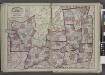
Hamilton, Herkimer counties.
1 : 158400 Bien, Joseph Rudolf
Binghamton
1 : 250000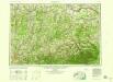
Binghamton
1 : 250000
Binghamton
1 : 250000
Binghamton
1 : 250000
Binghamton
1 : 250000
"Herkimer, Hamilton, and Montgomery"
from New topographical atlas and gazetteer of New York, comprising a topographical view of the several counties of the state, ... including ... map of the United States and territories ... Compiled from the latest astronomical observations, official surveys and records of the United States and territories ...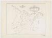
Map of the head waters of the rivers Susquehanna & Delaware embracing the early patents on the south side of the Mohawk River : from the original, drawn about the year 1790
1 : 260000 De Witt, Simeon, 1756-1834 Weed, Parsons & Co.
Hamilton County.
from Atlas of New York.