Maps of Stottville

Stottville
1 : 24000
Stottville
1 : 24000
Stottville
1 : 24000
Columbianville & Stockport [Village]; Stuyvesant [Village]; Stockport Business Notices.; Stottsville Business Notices.; Stottsville [Village]
from Atlas of Columbia County, New York. From actual surveys and official records. Compiled & published by D. G. Beers & Co.
Ghent [Township]
from Atlas of Columbia County, New York. From actual surveys and official records. Compiled & published by D. G. Beers & Co.
Kinderhook
1 : 62500
Kinderhook
1 : 62500
Kinderhook
1 : 62500
Kinderhook
1 : 62500
Kinderhook
1 : 62500
Kinderhook
1 : 62500
Kinderhook
1 : 62500
Kinderhook
1 : 62500
Kinderhook
1 : 62500
Kinderhook
1 : 62500
Stuyvesant Landing [Village]; Stockport [Township]
from Atlas of Columbia County, New York. From actual surveys and official records. Compiled & published by D. G. Beers & Co.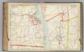
28 Greene, Columbia counties.
1 : 18000 Watson & Co. (New York, N.Y.)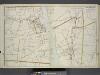
Portion of Greene County. ; Portion of Columbia County.
from Atlas of the Hudson River Valley from New York city to Troy, including a section of about 8 miles in width. Published by Watson & co. Compiled from official records and careful surveys, under the supervision of F. W. Beers.
Hollowville [Village]; Hollowville Business Notices.; Churchtown Business Notices.; Churchtown [Village]; Mellenville [Village]; Philmont Business Notices.; Philmont [Village]
from Atlas of Columbia County, New York. From actual surveys and official records. Compiled & published by D. G. Beers & Co.
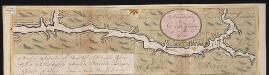
Hudson River & vicinity / drawn by David H. Burr ; S. Stiles & Co., N.Y.
from Hudson River
Claverack [Township]
from Atlas of Columbia County, New York. From actual surveys and official records. Compiled & published by D. G. Beers & Co.
Niverville [Village]; Kinderhook [Township]
from Atlas of Columbia County, New York. From actual surveys and official records. Compiled & published by D. G. Beers & Co.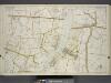
Portion of Greene County. ; Portion of Columbia County.
from Atlas of the Hudson River Valley from New York city to Troy, including a section of about 8 miles in width. Published by Watson & co. Compiled from official records and careful surveys, under the supervision of F. W. Beers.
Greenport [Township]
from Atlas of Columbia County, New York. From actual surveys and official records. Compiled & published by D. G. Beers & Co.
Stuyvesant [Township]; Stuyvesant Business Notices.
from Atlas of Columbia County, New York. From actual surveys and official records. Compiled & published by D. G. Beers & Co.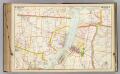
27 Greene, Columbia counties.
1 : 18000 Watson & Co. (New York, N.Y.)
Chatham Village [Village]; Chatham Village Business Notices.
from Atlas of Columbia County, New York. From actual surveys and official records. Compiled & published by D. G. Beers & Co.
New York
1 : 2000000 Breese, S.
Map of the Hudson River Rail Road from New York to Albany / engraved by Robt. Haering, N.Y. ; W.C. Moore, del.
from Hudson River