Maps of Town of Lumberland

Pond Eddy
1 : 24000
Pond Eddy
1 : 24000
Pond Eddy
1 : 24000
Pond Eddy
1 : 24000
Pond Eddy
1 : 24000
Pond Eddy
1 : 24000
Pond Eddy
1 : 24000
Milford
1 : 62500
Milford
1 : 62500
Milford
1 : 62500
Milford
1 : 62500
Milford
1 : 62500
Milford
1 : 62500
Milford
1 : 62500
Milford
1 : 62500
Milford
1 : 62500
Deer Park [Township]
from County atlas of Orange, New York / from actual surveys by and under the direction of F.W. Beers.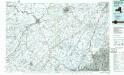
Middletown
1 : 100000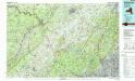
Middletown
1 : 100000
Sullivan County.
1 : 158400 Bien, Joseph Rudolf
Orange, Rockland counties.
1 : 151000 Burr, David H., 1803-1875
Wayne, Pike counties.
1 : 300000 Gray, Ormando Willis; Walling, H. F.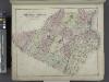
Outline Plan of Orange County New York.
from County atlas of Orange, New York / from actual surveys by and under the direction of F.W. Beers.
Map of the counties of Orange and Rockland / by David H. Burr ; engd. by Rawdon, Clark & Co., Albany, & Rawdon, Wright & Co., N. York.
from An atlas of the state of New York, designed for the use of engineers, containing a map of the state and of the several counties. / Projected and drawn ... under the superintendence and direction of Simeon de Witt.
Sunset Park, Bush Terminal. (cont.)
From District 7
Map of the counties of Orange and Rockland / by David H. Burr ; engd. by Rawdon, Clark & Co., Albany, & Rawdon, Wright & Co., N. York.
from An atlas of the state of New York : containing a map of the state and of the several counties / by David H. Burr.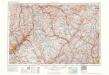
Scranton
1 : 250000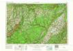
Scranton
1 : 250000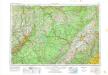
Scranton
1 : 250000
Scranton
1 : 250000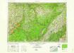
Scranton
1 : 250000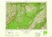
Scranton
1 : 250000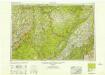
Scranton
1 : 250000

