Maps of Dutchess County

Pine Plains
1 : 24000
Pine Plains
1 : 24000
Pine Plains
1 : 24000
Pine Plains
1 : 24000
Pine Plains
1 : 24000
Map of Pine Plains Township. ; Pine Plains [Village]; Rock City [Village]
from New illustrated atlas of Dutchess County, New York. / Compiled & drawn from personal examinations, surveys etc. under the personal supervision of O.W. Gray & Son and F.A. Davis, and published under the superintendence of H. L. Kochersperger.
Stanford [Township]
from New illustrated atlas of Dutchess County, New York. / Compiled & drawn from personal examinations, surveys etc. under the personal supervision of O.W. Gray & Son and F.A. Davis, and published under the superintendence of H. L. Kochersperger.
Town of Stanford, Dutchess County, New York.
1 : 39600 Beers, Frederick W.
Millbrook
1 : 62500
Millbrook
1 : 62500
Millbrook
1 : 62500
Millbrook
1 : 62500
Millbrook
1 : 62500
Millbrook
1 : 62500
Millbrook
1 : 62500
Millbrook
1 : 62500
Millbrook
1 : 62500
Millbrook
1 : 62500
Millbrook
1 : 62500
Milan [Township]
from New illustrated atlas of Dutchess County, New York. / Compiled & drawn from personal examinations, surveys etc. under the personal supervision of O.W. Gray & Son and F.A. Davis, and published under the superintendence of H. L. Kochersperger.
Gallatin [Township]
from Atlas of Columbia County, New York. From actual surveys and official records. Compiled & published by D. G. Beers & Co.
Ancram [Township]
from Atlas of Columbia County, New York. From actual surveys and official records. Compiled & published by D. G. Beers & Co.
Town of Milan, Dutchess County New York. (insets) Milanville. Rock City. Lafayetteville. Jackson's Corners.
1 : 47639 Beers, Frederick W.
Map of Dutchess County New York
from New illustrated atlas of Dutchess County, New York. / Compiled & drawn from personal examinations, surveys etc. under the personal supervision of O.W. Gray & Son and F.A. Davis, and published under the superintendence of H. L. Kochersperger.
Dutchess County.
1 : 158400 Bien, Joseph Rudolf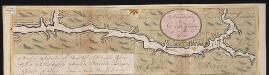
Nieuwe afteekeningh van de Noord Rivier met alle desselfs ancker plaetsen dieptens banken en klippen, geleegen in Nieuw Nederlandt [south part]
United States Gerard van Keulen
Dutchess, Putnam counties.
1 : 151000 Burr, David H., 1803-1875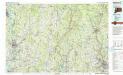
Waterbury
1 : 100000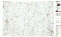
Waterbury
1 : 100000

