Maps of Town of Middletown

Margaretville
1 : 24000
Margaretville
1 : 24000
Margaretville
1 : 24000
Margaretville
1 : 24000
Margaretville [Village]; Griffins Corners [Village]; Lumberville [Village]; Clarks Factory [Village]; Hamden Business Directory
from Atlas of Delaware co., New York : from actual surveys by and under the direction of F. W. Beers assisted by A. B. Prindle & others
Margaretville
1 : 62500
Margaretville
1 : 62500
Margaretville
1 : 62500
Margaretville
1 : 62500
Margaretville
1 : 62500
Margaretville
1 : 62500
Margaretville
1 : 62500
Margaretville
1 : 62500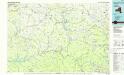
Pepacton Reservoir
1 : 100000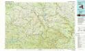
Pepacton Reservoir
1 : 100000
Delaware County.
1 : 151000 Burr, David H., 1803-1875
Map of the county of Greene / by David H. Burr ; engd. by Rawdon, Clark & Co., Albany, & Rawdon, Wright & Co., New York.
from An atlas of the state of New York : containing a map of the state and of the several counties. / Projected and drawn under the superintendence and direction of Simeon de Witt ... And also the physical geography of the State ...
Otsego, Delaware counties.
1 : 158400 Bien, Joseph Rudolf
Map of the county of Greene / by David H. Burr ; engd. by Rawdon, Clark & Co., Albany, & Rawdon, Wright & Co., New York.
from An atlas of the state of New York : containing a map of the state and of the several counties / by David H. Burr.
Map of the county of Ulster / by David H. Burr ; engd. by Rawdon, Clark & Co., Albany, & Rawdon, Wright & Co., New York.
from An atlas of the state of New York, designed for the use of engineers, containing a map of the state and of the several counties. / Projected and drawn ... under the superintendence and direction of Simeon de Witt.
Fulton, Montgomery, Schenectady, Schoharie, Greene counties.
1 : 158400 Bien, Joseph Rudolf
Map of the county of Greene / by David H. Burr ; engd. by Rawdon, Clark & Co., Albany, & Rawdon, Wright & Co., New York.
from An atlas of the state of New York, designed for the use of engineers, containing a map of the state and of the several counties. / Projected and drawn ... under the superintendence and direction of Simeon de Witt.
Schoharie County.
from Atlas of New York.
Binghamton
1 : 250000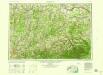
Binghamton
1 : 250000
Binghamton
1 : 250000
Binghamton
1 : 250000
Binghamton
1 : 250000
Map of the county of Ulster / by David H. Burr ; engd. by Rawdon, Clark & Co., Albany, & Rawdon, Wright & Co., New York.
from An atlas of the state of New York : containing a map of the state and of the several counties. / Projected and drawn under the superintendence and direction of Simeon de Witt ... And also the physical geography of the State ...

